
Bonneville Lock and Dam consists of several run-of-the-river dam structures that together complete a span of the Columbia River between the U.S. states of Oregon and Washington at River Mile 146.1. The dam is located 40 miles (64 km) east of Portland, Oregon, in the Columbia River Gorge. The primary functions of Bonneville Lock and Dam are electrical power generation and river navigation. The dam was built and is managed by the United States Army Corps of Engineers. At the time of its construction in the 1930s it was the largest water impoundment project of its type in the nation, able to withstand flooding on an unprecedented scale. Electrical power generated at Bonneville is distributed by the Bonneville Power Administration. Bonneville Lock and Dam is named for Army Capt. Benjamin Bonneville, an early explorer credited with charting much of the Oregon Trail. The Bonneville Dam Historic District was designated a National Historic Landmark District in 1987.
McNary Dam is a 1.4-mile (2.2-km) long concrete gravity run-of-the-river dam which spans the Columbia River. It joins Umatilla County, Oregon with Benton County, Washington, 292 miles (470 km) upriver from the mouth of the Columbia. It is operated by the U.S. Army Corps of Engineers' McNary Lock and Dam office. The dam is located a mile (2 km) east of the town of Umatilla, Oregon, and 8 miles (13 km) north of Hermiston, Oregon. The dam was originally planned to be named Umatilla Dam, but the Flood Control Act of 1945 renamed the dam in honor of Senator Charles L. McNary of Oregon, who had died the previous year.

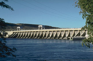
The Dalles Dam is a concrete-gravity run-of-the-river dam spanning the Columbia River, two miles (3 km) east of the city of The Dalles, Oregon, United States. It joins Wasco County, Oregon with Klickitat County, Washington, 192 miles (309 km) upriver from the mouth of the Columbia near Astoria, Oregon. The closest towns on the Washington side are Dallesport and Wishram.

The John Day Dam is a concrete gravity run-of-the-river dam spanning the Columbia River in the northwestern United States. The dam features a navigation lock plus fish ladders on both sides. The John Day Lock has the highest lift (110 feet) of any U.S. lock. The reservoir impounded by the dam is Lake Umatilla, and it runs 76.4 miles up the river channel to the foot of the McNary Dam. John Day Dam is part of the Columbia River Basin system of dams.

Lake Allatoona is a U.S. Army Corps of Engineers reservoir on the Etowah River in northwestern part of the State of Georgia, in the countryside. This reservoir is mostly in southeastern Bartow County and southwestern Cherokee County. A small portion is located in Cobb County near Acworth. Cartersville is the nearest city to Allatoona Dam. Also, Red Top Mountain State Park is located on its shores, on the peninsula between the two arms of the lake. Most of the north side of the lake remains protected from land development because of its isolated location, mostly blocked by the lake.

The Dale Hollow Reservoir is a reservoir situated on the Kentucky/Tennessee border. The lake is formed by the damming of the Obey River, 7.3 miles (12 km) above its juncture with the Cumberland River at river mile 380. Portions of the lake also cover the Wolf River. Dale Hollow is one of four major flood control reservoirs for the Cumberland; the others being J. Percy Priest Dam, Wolf Creek Dam, and Center Hill Dam. It is also the site of Dale Hollow Lake State Park on the north (Kentucky) side.

The McAlpine Locks and Dam are a set of locks and a hydroelectric dam at the Falls of the Ohio River at Louisville, Kentucky. They are located at mile point 606.8 and control a 72.9 miles (117.3 km) long navigation pool. The locks and their associated canal were the first major engineering project on the Ohio River, completed in 1830 as the Louisville and Portland Canal, designed to allow shipping traffic to navigate through the Falls of the Ohio.

Dworshak Dam is a concrete gravity dam in the western United States, on the North Fork Clearwater River in Clearwater County, Idaho. The dam is located approximately four miles (6 km) northwest of Orofino and impounds the Dworshak Reservoir for flood control and hydroelectricity generation. With a height of 717 feet (219 m), Dworshak is the third tallest dam in the United States and the tallest straight-axis concrete dam in the Western Hemisphere. Construction of the dam by the U.S. Army Corps of Engineers (USACE) began in 1966 and was completed in 1973.

Guntersville Dam is a hydroelectric dam on the Tennessee River in Marshall County, in the U.S. state of Alabama. It is one of nine dams on the river owned and operated by the Tennessee Valley Authority, which built the dam in the late 1930s as part of a New Deal era initiative to create a continuous navigation channel on the entire length of the river and bring flood control and economic development to the region. The dam impounds the Guntersville Lake of 67,900 acres (27,500 ha), and its tailwaters feed into Wheeler Lake.

Wheeler Dam is a hydroelectric dam on the Tennessee River between Lauderdale County and Lawrence County in Alabama. It is one of nine dams on the river owned and operated by the Tennessee Valley Authority, which built the dam in the mid-1930s as part of a New Deal-era initiative to improve navigation on the river and bring flood control and economic development to the region. The dam impounds the Wheeler Lake of 67,070 acres (27,140 ha) and its tailwaters feed into Wilson Lake.

Carters Dam is an earthen embankment dam located south of Chatsworth in Murray County and west of Ellijay in northwestern Georgia, United States, that creates Carters Lake.

Gavins Point Dam is a 1.9 mi (3 km) long embankment rolled-earth and chalk-fill dam which spans the Missouri River and impounds Lewis and Clark Lake. The dam joins Cedar County, Nebraska with Yankton County, South Dakota a distance of 811.1 river miles (1,305 km) upstream of St. Louis, Missouri, where the river joins the Mississippi River. The dam and hydroelectric power plant were constructed as the Gavins Point Project from 1952 to 1957 by the United States Army Corps of Engineers as part of the Pick-Sloan Plan. The dam is located approximately 4 miles (6.4 km) west or upstream of Yankton, South Dakota.

Pickwick Landing Dam is a hydroelectric dam on the Tennessee River in Hardin County, in the U.S. state of Tennessee. The dam is one of nine dams on the river owned and operated by the Tennessee Valley Authority, which built the dam in the 1930s as part of a New Deal-era initiative to create a continuous navigation channel between the river's mouth and Knoxville, and bring economic development to the area. The dam impounds the 43,100-acre (17,400 ha) Pickwick Lake and its tailwaters are part of Kentucky Lake.

The Chickamauga Dam is a hydroelectric dam on the Tennessee River in Chattanooga, Tennessee, United States. The dam is owned and operated by the Tennessee Valley Authority, which built the dam in the late 1930s as part of a New Deal era initiative to improve navigation and bring flood control and economic development to the Tennessee Valley. The dam impounds the 36,240-acre (14,670 ha) Chickamauga Lake and feeds into Nickajack Lake. The dam and associated infrastructure were listed on the National Register of Historic Places in 2017.

Kentucky Dam is a hydroelectric dam on the Tennessee River on the county line between Livingston and Marshall counties in the U.S. state of Kentucky. The dam is the lowermost of nine dams on the river owned and operated by the Tennessee Valley Authority, which built the dam in the late 1930s and early 1940s to improve navigation on the lower part of the river and reduce flooding on the lower Ohio and Mississippi rivers. It was a major project initiated during the New Deal of President Franklin D. Roosevelt's administration, to invest in infrastructure to benefit the country. The dam impounds the Kentucky Lake of 160,000 acres (65,000 ha), which is the largest of TVA's reservoirs and the largest artificial lake by area in the Eastern United States. It was listed on the National Register of Historic Places in 2017.

Bankhead Lake is a reservoir along the Black Warrior River that begins in Walker County in the state of Alabama. The lake forms the border between Jefferson and Tuscaloosa County, as well as the border dividing Jefferson and Walker County. It eventually empties into Holt Lake.

Summersville Lake is a reservoir located in the US state of West Virginia. The lake is formed by a rock-fill dam on the Gauley River, south of Summersville in Nicholas County. It is the largest lake in West Virginia, with 2,700 acres (1,100 ha) of water and over 60 miles (97 km) of shoreline at the summer pool water level. Its maximum depth is 327 feet.

The Holt Lock and Dam is a lock built on the Black Warrior River near Holt, Alabama in Tuscaloosa County. Opening for navigation in 1966, it served as a replacement for a series locks and dams built in the early 20th century. The lock and dam impounds Holt Lake 19 miles (31 km) upstream to the John Hollis Bankhead Lock and Dam.


