This page documents the tornadoes and tornado outbreaks that occurred in 2007, primarily in the United States. Most tornadoes form in the U.S., although some events may take place internationally, particularly in parts of neighboring southern Canada during the summer season. Some tornadoes also take place in Europe, e. g. in the United Kingdom or in Germany.
The tornado outbreak of February 28 – March 2, 2007 was a deadly tornado outbreak across the southern United States that began in Kansas on February 28, 2007. The severe weather spread eastward on March 1 and left a deadly mark across the southern US, particularly in Alabama and Georgia. Twenty deaths were reported; one in Missouri, nine in Georgia, and 10 in Alabama. Scattered severe weather was also reported in North Carolina on March 2, producing the final tornado of the outbreak before the storms moved offshore into the Atlantic Ocean.
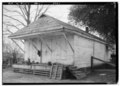
Sawyerville, previously known as Sawyers Depot, is an unincorporated community in west-central Hale County, Alabama and is a part of the Tuscaloosa metropolitan area. It derives its name from the town's first post master. The community is rural and came to flourish due to its proximity to the railroad that once traveled through it. The community covers the historic area of the county once called Hollow Square and includes the abandoned town site of Erie, the former county seat of Greene County. It also includes the communities of Wedgeworth, Melton, Warrior Dam, and Mason Bend. The area was the site of several Pickens family plantations, most notably those of early Alabama governor, Israel Pickens, and his younger brother, Samuel Pickens. The Samuel Pickens homestead, Umbria Plantation, was destroyed by fire in 1971.

On December 23, 2015, an outbreak of supercell thunderstorms produced tornadoes across northern Mississippi and middle Tennessee, resulting in 13 tornado-related deaths and numerous injuries. Other tornadoes occurred as far north as Indiana and Michigan. Scattered tornado activity continued over the next two days before the outbreak ended. This was the first of two deadly tornado outbreaks to impact the southern United States during December 2015 with the other occurring just a day after this one ended.

An unusually prolific and very destructive late-winter tornado outbreak resulted in significant damage and numerous casualties across the southern and eastern half of the United States between February 23–24, 2016. Lasting over a day and a half, the outbreak produced a total of 61 tornadoes across eleven states, which ranked it as one of the largest February tornado outbreaks in the United States on record, with only the 2008 Super Tuesday tornado outbreak having recorded more. In addition, it was also one of the largest winter tornado outbreaks overall as well. The most significant and intense tornadoes of the event were four EF3s that struck southeastern Louisiana, Pensacola, Florida, Evergreen, Virginia, and Tappahannock, Virginia. Tornadoes were also reported in other places like Texas, Florida, and Pennsylvania. Severe thunderstorms, hail and gusty winds were also felt in the Northeastern United States and Mid-Atlantic states on February 24 as well.

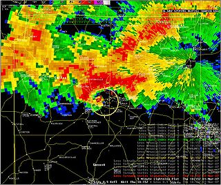
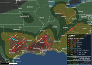
A significant and deadly severe weather event that affected the Southeastern United States on March 3, 2019. Over the course of 6 hours, a total of 41 tornadoes touched down across portions of Alabama, Georgia, Florida, and South Carolina. The strongest of these was an EF4 tornado that devastated rural communities from Beauregard, Alabama through Smiths Station, Alabama to Talbotton, Georgia, killing 23 people and injuring at least 100 others. Its death toll represented more than twice the number of tornado deaths in the United States in 2018 as well as the deadliest single tornado in the country since the 2013 Moore EF5 tornado. An EF3 tornado also destroyed residences to the east of Tallahassee in Leon County, Florida, and was only the second tornado of that strength in the county since 1945. Several other strong tornadoes occurred across the region throughout the evening of March 3 and caused significant damage. A large number of EF0 and EF1 tornadoes also touched down.

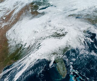
The March 2019 North American blizzard was a powerful Colorado Low that produced up to two feet of snow in the plains and Midwest. Rapid snowmelt following the storm caused historic flooding, and some areas received hurricane-force wind gusts. Comparable to the 1993 Storm of the Century, the storm was labeled a bomb cyclone after barometric pressure readings dropped in excess of 24 mbar (0.71 inHg) over a 24-hour period. After the storm entered Colorado from its origination in Arizona, the pressure dropped more than 30 mbar (0.89 inHg) and rapidly intensified over the western High Plains. The severe storm set new all-time record low barometric pressure readings in Colorado, Kansas and New Mexico. The storm itself killed only one person in Colorado, but flooding caused by the storm killed at least 3, one in Iowa and at least two in Nebraska and left ~140,000 without power in Texas.

This page documents notable tornadoes and tornado outbreaks worldwide in 2020. Strong and destructive tornadoes form most frequently in the United States, Argentina, Brazil, Bangladesh, and eastern India, but can occur almost anywhere under the right conditions. Tornadoes also develop occasionally in southern Canada during the Northern Hemisphere's summer and somewhat regularly at other times of the year across Europe, Asia, Argentina, Australia and New Zealand. Tornadic events are often accompanied by other forms of severe weather, including strong thunderstorms, strong winds, and hail.
A significant and deadly tornado outbreak sequence took place from March 24–28, 2021 in the Southern United States just one week after another outbreak affected similar regions. There were 43 tornadoes confirmed across 11 states, with the bulk of activity primarily on March 25, which resulted in the Storm Prediction Center (SPC) issuing its second high-risk outlook for the month of March, as well as the second high-risk outlook for 2021. Several intense tornadoes touched down on that day, including ones that prompted the issuance of rare tornado emergencies near Hoover, Alabama, Brent and Centreville, Alabama, and in the Newnan, Georgia area. March 27 also saw widespread tornado activity mainly across East Texas, Southern Arkansas, Louisiana, and Western Tennessee with several strong tornadoes touching down. Scattered to widespread wind and hail damage occurred throughout the outbreak sequence, and repeated rounds of heavy rain caused widespread severe flash and river flooding across much of Tennessee.

Hurricane Ida generated a tornado outbreak as it traversed the Southeastern, Mid-Atlantic, and Northeastern United States. Thirty-five confirmed tornadoes touched down from Mississippi to Massachusetts; one person was killed in Upper Dublin Township, Pennsylvania, and several people were injured in Alabama, New Jersey, and Pennsylvania. The most active and destructive part of the outbreak occurred during the afternoon of September 1, when several strong tornadoes struck Maryland, New Jersey, and Pennsylvania, including an EF3 tornado which impacted Mullica Hill, New Jersey. The same storm later dropped an EF1 tornado that prompted a tornado emergency for Burlington, New Jersey and Croydon, and Bristol, Pennsylvania, the first of its kind in the Northeast, as well as the first such alert associated with a tropical cyclone. This outbreak severely impacted New Jersey and the Philadelphia Metropolitan Area, a region which had been significantly impacted by strong tornadoes from another outbreak that occurred just over a month prior as well as several weak tornadoes from the remnants of Tropical Storm Fred two weeks earlier. Overall, the 35 tornadoes killed one person and injured seven others.

A deadly late-season tornado outbreak, the deadliest on record in December, produced catastrophic damage and numerous fatalities across portions of the Southern United States and Ohio Valley from the evening of December 10 to the early morning of December 11, 2021. The event developed as a trough progressed eastward across the United States, interacting with an unseasonably moist and unstable environment across the Mississippi Valley. Tornado activity began in northeastern Arkansas, before progressing into Missouri, Illinois, Tennessee, and Kentucky.
A large tornado outbreak struck the Southern region of the United States on March 21–22, 2022, before transitioning to the Eastern United States on March 23. The outbreak started with numerous supercell thunderstorms and severe squall lines developing in central Texas and southern Oklahoma, prompting the issuance of numerous tornado warnings, including multiple PDS tornado warnings. An EF3 tornado caused considerable damage in Jacksboro, Texas while an EF2 tornado from the same storm caused a fatality in Sherwood Shores. Other strong tornadoes caused damage near College Station and in the Austin and Houston metropolitan areas. Severe and tornadic activity continued into the next day as the system moved eastward with numerous tornadoes reported in Mississippi and Alabama. On the evening of March 22, a supercell moved through the New Orleans metropolitan area, with an EF3 tornado producing severe damage in Arabi, resulting in one death and at least two injuries. Widespread flooding also accompanied the decaying squall line in Alabama. Tornadoes occurred on March 23 over the Eastern United States, associated with the same system, including EF2 tornadoes near Pickens, South Carolina, and Gladesboro, Virginia. In all, 81 tornadoes were confirmed.

From March 29–31, 2022, a line of strong to severe thunderstorms and multiple supercells brought widespread wind damage and several strong tornadoes across a large part of the Midwestern, Southern, and Eastern United States. An EF3 tornado was confirmed in Springdale, Arkansas, while an EF1 tornado passed close to downtown Jackson, Mississippi. Numerous tornadoes, some of which were strong occurred over Mississippi, Alabama the evening of March 30 and into the early morning of March 31. Multiple tornadoes also occurred in the Florida Panhandle, including an intense EF3 tornado that killed two people and injured three others near Alford, Florida, and in other states such as North Carolina and Pennsylvania.