
Winona County is a county in the U.S. state of Minnesota. As of the 2010 census, its population was 51,461. Its county seat is Winona.

Mower County is a county in the U.S. state of Minnesota. As of the 2010 United States Census, the population was 39,163, and was estimated to have a population of 40,011 as of 2018. The county seat is Austin.

Goodhue County is a county in the U.S. state of Minnesota. As of the 2010 census, the population was 46,183. Its county seat is Red Wing. Nearly all of Prairie Island Indian Community is within the county.

Blue Earth County is a county in the State of Minnesota. As of the 2010 United States Census, the population was 64,013. Its county seat is Mankato. The county is named for the Blue Earth River and for the deposits of blue-green clay once evident along the banks of the Blue Earth River.
Lake View Township is a township in Becker County, Minnesota, United States. The population was 1,685 at the 2010 census.
Cass Lake is a city in Cass County, Minnesota, United States, located within the boundaries of the Leech Lake Indian Reservation. It is surrounded by Pike Bay Township. Cass Lake had a population of 770 in the 2010 census. It is notable as the headquarters location of Minnesota Chippewa Tribe and Leech Lake Band of Ojibwe, as well as the Chippewa National Forest.

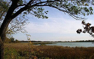
Lake Bemidji is a small glacially-formed lake, approximately 11 square miles in area, in northern Minnesota in the United States. Located less than 50 miles (80 km) downstream from the source of the Mississippi River, it both receives and is drained by the Mississippi.

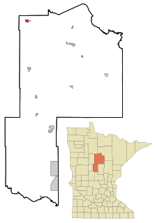
Central Minnesota is the region consisting of the central portion of the state of Minnesota. Although no specific boundaries of the region exist, most definitions of what makes up the region would generally consist of the vast swath of land north of Interstate 94, east of U.S. Highway 59, south of U.S. Highway 2, and west of U.S. Highway 169.

Lake Louise State Park is a Minnesota state park just north of the Iowa border near the small town of Le Roy in Mower County, Minnesota, directly south of Rochester. It has a 25 acre man-made lake and 1,168 acres (5 km2) of mixed prairie and deciduous forest. It is used for picnics, swimming, camping, hiking, horseback riding, and other outdoor recreation. It is noted for butterfly watching, as some rare species have been seen. It features a picnic shelter which dates to the Public Works Administration era.
The Middle River is a tributary of the Snake River in northwestern Minnesota in the United States. It flows for its entire length in Marshall County.
Rice Lake State Park is a state park of Minnesota, United States, just east of Owatonna. Park lands entirely surround Rice Lake, an important stopping point for migrating waterfowl. The lake covers 750 acres (300 ha) with an average depth of 3 feet (1 m).
Roberds Lake is a lake in Rice County, in the U.S. state of Minnesota.

Terrebonne is a former townsite on the Clearwater River in Terrebonne Township, Red Lake County, Minnesota, United States. In 1901, the village of Terrebonne was the site of a thriving flour mill, a cheese factory, a blacksmith shop, a general store and an "eating place", the latter operated by Mrs. Lajeunesse, in addition to a number of residences. In 1920, it was reported to have as many as 119 residents. The St. Anthony of Padua Catholic Church, founded in the spring of 1879, was closed in 2000, and burned down on April 29th, 2016. The other establishments of the town have long since disappeared. The flour mill burned down in 1915, was rebuilt, and burned down for good on July 4, 1954. The area was settled by farmers primarily of French-Canadian descent, and remains at the center of an extremely rural farming community.
Belvidere Mills is an unincorporated community in Belvidere Township, Goodhue County, Minnesota, United States.
Day is an unincorporated community in Maple Ridge Township, Isanti County, Minnesota, United States.
Hay Creek is an unincorporated community in Hay Creek Township, Goodhue County, Minnesota, United States.
Albright is an unincorporated community in Middleville Township, Wright County, Minnesota, United States. The community is located along Wright County Road 5 near 15th Street SW. Nearby places include Howard Lake, Cokato, Albion Center, and Albright Mill County Park. The North Fork of the Crow River flows nearby.
Smiths Mill is an unincorporated community in Blue Earth and Waseca counties in the U.S. state of Minnesota. The community is located along 631st Avenue near 206th Street and U.S. Highway 14. Smiths Mill is located within Le Ray Township in Blue Earth County; and also located within Janesville Township in Waseca County. Nearby places include Janesville and Eagle Lake.
