Related Research Articles

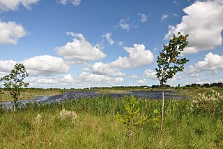
A bog or bogland is a wetland that accumulates peat, a deposit of dead plant material—often mosses, and in a majority of cases, sphagnum moss. It is one of the four main types of wetlands. Other names for bogs include mire, mosses, quagmire, and muskeg; alkaline mires are called fens. A baygall is another type of bog found in the forest of the Gulf Coast states in the USA. They are often covered in heath or heather shrubs rooted in the sphagnum moss and peat. The gradual accumulation of decayed plant material in a bog functions as a carbon sink.

Ireland is an island in Northwestern Europe in the north Atlantic Ocean. The island lies on the European continental shelf, part of the Eurasian Plate. The island's main geographical features include low central plains surrounded by coastal mountains. The highest peak is Carrauntoohil, which is 1,041 meters (3,415 ft) above sea level. The western coastline is rugged, with many islands, peninsulas, headlands and bays. The island is bisected by the River Shannon, which at 360.5 km (224 mi) with a 102.1 km (63 mi) estuary is the longest river in Ireland and flows south from County Cavan in Ulster to meet the Atlantic just south of Limerick. There are a number of sizeable lakes along Ireland's rivers, of which Lough Neagh is the largest.

County Westmeath is a county in Ireland. It is in the province of Leinster and is part of the Midlands Region. It originally formed part of the historic Kingdom of Meath. It was named Mide because the kingdom was located in the geographical centre of Ireland. Westmeath County Council is the administrative body for the county, and the county town is Mullingar. At the 2016 census, the population of the county was 88,770.

County Offaly is a county in Ireland. It is part of the Midlands Region and is also located in the province of Leinster. It is named after the ancient Kingdom of Uí Failghe. It was formerly known as King's County. Offaly County Council is the local authority for the county. The county population was 77,961 at the 2016 census.

The Bog of Allen is a large raised bog in the centre of Ireland between the rivers Liffey and Shannon.

Cam Ranh International Airport is located on Cam Ranh Bay in Cam Ranh, a town in Khánh Hòa Province in Vietnam. It serves the city of Nha Trang, which is 30 km (16 NM) from the airport. This airport handled 9,747,172 passengers in 2019, making it the fourth busiest airport in Vietnam, after the ones in Ho Chi Minh City, Hanoi and Da Nang, and one of the fastest growing airports in the country.
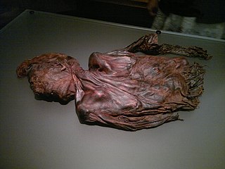
Clonycavan Man is the name given to a well-preserved Iron Age bog body found in Clonycavan, Ballivor, County Meath, Ireland in March 2003. The body shows signs of having been murdered. Theories around the meanings and manner of his death vary.

Ballinahown, also spelled Ballynahown, is a village in County Westmeath on the N62 regional road in Ireland. It is 10 km (6.2 mi) south of Athlone and 5 km (3.1 mi) east of the River Shannon. It contains the Roman Catholic St. Colmcilles Church, completed in 1902 to a design in the Early English Gothic-style by William Hague.
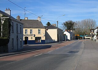
Milltownpass is a village in County Westmeath, Ireland. It is located in the south of the county on the R446 regional road. The old route was replaced by a dual-carriageway from Kinnegad to Tyrrellspass in 2006, bypassing the village. Milltownpass is the second largest village in the parish of Rochfortbridge. It was one of the first villages in Ireland to have its own electricity supply: a mill on the Milltown River providing power to the village long before rural electrification.
Clara Bog is one of the largest relatively intact raised bogs remaining in Ireland. It lies southeast of the R436 regional road between the village of Ballycumber and the town of Clara, in County Offaly. Much of the bog is state-owned and managed as a nature reserve covering some 460 ha. A Special Area of Conservation covers 836 ha.
Lios an Gharráin is a townland of Moycullen near Barna in County Galway, Ireland. There are only 10 houses, and no shops or schools. There is one horse riding school, the Moycullen Riding Centre. There are roughly 24 inhabitants. It is close to the Moycullen Bogs.
Boora Bog is a cutaway peat bog situated in County Offaly, Ireland. Peat was harvested for fuel between the 1950s and 1970s, and the land is now being reclaimed for agricultural and eco-tourism use. There was a lake called Lough Boora, which was drained by Bord na Móna, but was not used for peat production: this area is now maintained as a nature reserve by the Irish Wildlife Trust. There are two angling lakes.
The Little Bog River is a short stream in Hancock County, Maine. From its source in Osborn, the river runs 5.4 miles (8.7 km) south to its confluence with Mill Brook in Eastbrook. Mill Brook flows west to Webb Pond. Via Mill Brook, Webb Pond, and Webb Brook, the Little Bog River is part of the Union River watershed.
Raheenmore Bog is a raised bog north-west of Daingean, County Offaly, in Ireland. Since the 1980s the greater part of the bog has been maintained as a 162 hectare Nature Reserve, which is currently managed by the National Parks and Wildlife Service. A Special Area of Conservation covers 182 ha, including some land in private ownership.
German submarine U-453 was a Type VIIC U-boat built for Nazi Germany's Kriegsmarine for service during World War II. She was laid down on 4 July 1940 by Deutsche Werke in Kiel as yard number 284, launched on 30 April 1941 and commissioned on 26 June 1941 under Kapitänleutnant Egon-Reiner von Schlippenbach.
Scohaboy Bog is a raised bog in County Tipperary in Ireland. It lies approximately 6 km northwest of Cloughjordan, County Tipperary, between the N52 and R490 roads.
Cloncrow Bog is a peat bog in County Westmeath, Ireland. The bog is near the village of Tyrrellspass on the R446 regional road.
Corcloon is a townland in Milltownpass in County Westmeath, Ireland. The townland is in the civil parish of Pass of Kilbride.
Gaulstown, also spelt Gallstown is a townland in County Westmeath, Ireland. The townland is located in between the towns of Rochfortbridge and Milltownpass, close to the R446 regional road.. Neighbouring townlands include Bellfield, Corcloon, Drumman, Milltown and Windmill to the east, Gibbonstown and Gortumly to the west and Mahonstown to the north.

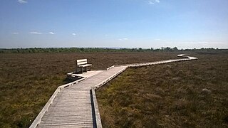
Pass of Kilbride is a townland in County Westmeath, Ireland. The townland is located on the border with County Offaly and is in the civil parish of the same name. The M6 Motorway runs through the south, with the R400 regional road running through the middle. The Monagh River flows through the south of the area, with the Milltown River forming the western border as it meets the village of Milltownpass, and the Kinnegad River forming the eastern border. The Milltownpass Bog is in the northern part of the townland.
References
- ↑ "Milltownpass Bog NHA | National Parks & Wildlife Service". www.npws.ie. Retrieved 27 March 2019.
- ↑ "Milltownpass Bog NHA". Protected Planet. Retrieved 27 March 2019.
Coordinates: 53°27′11″N7°13′23″W / 53.453°N 7.223°W
| | This article related to the geography of County Westmeath, Ireland is a stub. You can help Wikipedia by expanding it. |