Antonio Raymondi is a province of the Ancash Region in Peru. It is located along the central eastern edge of the Ancash Region, bordering the Huánuco Region.

The Huari Province is one of twenty provinces of the Ancash Region in Peru. Its seat is Huari.
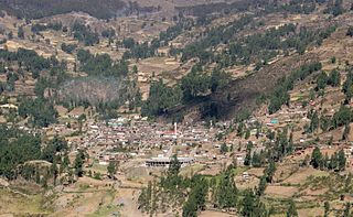
Huari is one of the 16 districts that integrates the Peruvian province of Huari in the Ancash region. The district consists of the city of Huari, 15 small villages and 22 annexes.
Cajay District is one of sixteen districts of the Huari Province in Peru.
Pumaq Hirka is an archaeological site in Peru. It is situated in the Huánuco Region, Huamalíes Province, Miraflores District, at a height of about 3,696 metres (12,126 ft).
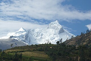
Markahirka or Marka Hirka is an archaeological site with cave paintings and stone tombs (chullpa) on a mountain of the same name in Peru. It is located in the Ancash Region, Huari Province, in the districts of Cajay and Masin. It is situated at a height of 3,580 metres (11,745 ft). Markahirka is also a good viewpoint with views into the Puchka valley (Puchca) and to the towns of Huari (Wari) and Huachis (Wachis).
Warahirka or Wara Hirka is a mountain with an archaeological site of the same name in Peru. It is situated in the Huánuco Region, Yarowilca Province, Pampamarca District, about 1.5 km from Pampamarca, near La Florida and Warahirka (Huarajirca).

Waylla Hirka is a mountain in the Andes of Peru, about 4,800 metres (15,748 ft) high. It is located in the Lima Region, Cajatambo Province, Cajatambo District. Waylla Hirka lies at the Pumarinri valley south of the Waywash mountain range, southwest of Pukaqaqa and north of Millpu. The lakes Quyllurqucha, Warmiqucha and Challwaqucha lie northeast of Waylla Hirka.
Puka Hirka is a mountain in the Cordillera Negra in the Andes of Peru, about 4,600 m (15,100 ft) high. It is situated in the Ancash Region, Aija Province, on the border of the districts of Aija and La Merced, in the Huaraz Province, Huaraz District, and in the Recuay Province, Recuay District.
Huayllajirca is a mountain in the Andes of Peru, about 5,000 m (16,000 ft) high. It is located in the Lima Region, Cajatambo Province, Cajatambo District, and in the Oyón Province, Oyón District. Huayllajirca lies northwest of the mountain named Chalhuacocha and northeast of Pishtac and Tocto lake.
Sach'a Hirka is a mountain in the Cordillera Negra in the Andes of Peru which reaches a height of approximately 4,600 m (15,100 ft). It lies in the Ancash Region on the border of the Aija Province, Aija District, and the Recuay Province, Catac District. Sach'a Hirka lies northwest of Yana Kunkush.
Kushuru Hirka is a mountain in the Cordillera Negra in the Andes of Peru which reaches a height of approximately 4,600 m (15,100 ft). It lies in the Ancash Region, Recuay Province, on the border of the districts of Cotaparaco and Tapacocha.
Ututu Hirka is a mountain in the Cordillera Negra in the Andes of Peru which reaches a height of approximately 4,600 m (15,100 ft). It lies in the Ancash Region, Huarmey Province, on the border of the districts of Huayan and Malvas. Ututu Hirka lies southeast of Pillaka.
Putaqa Hirka is a mountain in the eastern extensions of the Cordillera Blanca in the Andes of Peru which reaches a height of approximately 4,200 m (13,800 ft). It is located in the Ancash Region, Huari Province, on the border of the districts of Cajay and Masin.
Quinuajirca or Kinwa Hirka is a mountain in the eastern extensions of the Cordillera Blanca in the Andes of Peru which reaches a height of approximately 4,400 m (14,400 ft). It is located in the Ancash Region, Huari Province, Huari District. Quinuajirca lies at the Rurichinchay valley, northeast of the peak of Chinchey.
Jatunjirca is a mountain in the eastern part of the Cordillera Blanca in the Andes of Peru which reaches a height of approximately 3,800 m (12,500 ft). It is located in the Ancash Region, Huari Province, Huari District, southwest of Huari and west of the village of Yacya.
Hatun Hirka may refer to:
Qullpa Hirka is a mountain in the Cordillera Negra in the Andes of Peru which reaches a height of approximately 4,400 m (14,400 ft). It lies in the Ancash Region, Recuay Province, in the northern part of the Cotaparaco District.
Yanajirca or Yana Hirka is a mountain in the Andes of Peru which reaches an altitude of approximately 4,800 m (15,700 ft). It is located in the Ancash Region, Bolognesi Province, on the border of the districts of Huallanca and Huasta. Yana Hirka lies east of Wamash Mach'ay.
Yanajirca or Yana Hirka is a mountain in the Andes of Peru which reaches an altitude of approximately 4,600 m (15,100 ft). It is located in the Ancash Region, Bolognesi Province, Huallanca District. Yana Hirka lies southeast of the Wallanka mountain range.