Milnrow Urban District

Last updated

Milnrow Urban District
Area
  19115,194 acres (21.02 km2)
  19615,195 acres (21.02 km2)
Population
  19118,584
  197110,345
History
  Created1894
  Abolished1974
  Succeeded by Metropolitan Borough of Rochdale
Status Urban district
   HQ Milnrow Town Hall
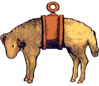
Banded fleece of Milnrow.png

Milnrow Urban District was, from 1894 to 1974, a local government district of the administrative county of Lancashire, in northwest England. It covered an area to the east and southeast of the County Borough of Rochdale, and included the town of Milnrow, the village of New Hey, and the Piethorne Valley; Crompton Urban District lay to the south.

Milnrow Urban District was created by the Local Government Act 1894, and was for the most part the successor to the township of Butterworth. In 1974, Milnrow Urban District was abolished by the Local Government Act 1972 and its former area transferred to Greater Manchester to form part of the Metropolitan Borough of Rochdale.

Related Research Articles

<span class="mw-page-title-main">Metropolitan Borough of Rochdale</span> Borough of Greater Manchester, England

The Metropolitan Borough of Rochdale is a metropolitan borough of Greater Manchester in England. Its largest town is Rochdale and the wider borough covers other outlying towns and villages, including Middleton, Heywood, Milnrow and Littleborough. It is the ninth-largest district by population in Greater Manchester with a population of 224,087 in 2021.

<span class="mw-page-title-main">Milnrow</span> Human settlement in England

Milnrow is a town within the Metropolitan Borough of Rochdale, in Greater Manchester, England. It lies on the River Beal at the foothills of the South Pennines, and forms a continuous urban area with Rochdale. It is 2 miles (3.2 km) east of Rochdale town centre, 10 miles (16.1 km) north-northeast of Manchester, and spans from Windy Hill in the east to the Rochdale Canal in the west. Milnrow is adjacent to junction 21 of the M62 motorway, and includes the village of Newhey, and hamlets at Tunshill and Ogden.

<span class="mw-page-title-main">Littleborough, Greater Manchester</span> Town in Rochdale, England

Littleborough is a town in the Metropolitan Borough of Rochdale, Greater Manchester, England, in the upper Roch Valley by the foothills of the South Pennines, 3 miles (4.8 km) northeast of Rochdale and 13 miles (20.9 km) northeast of Manchester; Milnrow and the M62 motorway are to the south, and the rural uplands of Blackstone Edge to the east. According to the 2001 census, Littleborough, and its suburbs of Calderbrook, Shore and Smithy Bridge, had a population of 13,807.

<span class="mw-page-title-main">Wardle, Greater Manchester</span> Human settlement in England

Wardle is a village near Littleborough within the Metropolitan Borough of Rochdale, in Greater Manchester, England. It lies amongst the foothills of the South Pennines, 1.8 miles (2.9 km) east-southeast of Whitworth, 2.5 miles (4 km) north-northwest of Rochdale and 12 miles (19 km) north-northeast of the city of Manchester.

Crompton Urban District was, from 1894 to 1974, a local government district in the administrative county of Lancashire, England. The area was coterminate with Shaw and Crompton.

<span class="mw-page-title-main">Standish-with-Langtree</span> Former local government area in North West England

Standish-with-Langtree was, and to a limited extent remains, a local government district centred on Standish, Lancashire, in North West England. Historically it was an ancient township in the hundred of West Derby and county of Lancashire. This unit was abolished in 1974 following the Local Government Act 1972, the same act which established Greater Manchester.

<span class="mw-page-title-main">Municipal Borough of Swinton and Pendlebury</span>

Swinton and Pendlebury was a local government district of the administrative county of Lancashire, England. It was created in 1894 as an urban district and enlarged in 1934, gaining the status of a municipal borough.

Bury was a rural district in Lancashire, England from its establishment in 1894 under the Local Government Act 1894, until its abolition in 1933. The district consisted of a number of rural civil parishes near Bury, but did not include Bury itself. It was a successor to the Bury Rural Sanitary District.

<span class="mw-page-title-main">Newhey</span> Human settlement in England

Newhey is a village near the town of Milnrow in the Metropolitan Borough of Rochdale, in Greater Manchester, England. It lies at the foot of the South Pennines, by Junction 21 of the M62 motorway and on the River Beal, 3 miles (4.8 km) east-southeast of Rochdale, 10 miles (16.1 km) northeast of Manchester.

Lees was from 1894 to 1974, a local government district in the administrative county of Lancashire, England.

<span class="mw-page-title-main">Chadderton Urban District</span>

Chadderton Urban District was, from 1894 to 1974, a local government district of the administrative county of Lancashire, England. It was centred on the town of Chadderton.

Denton Urban District was a local government district in England from 1894 to 1974.

The County Borough of Wigan was, from 1889 to 1974, a local government district centred on Wigan in the northwest of England. It was alternatively known as Wigan County Borough.

<span class="mw-page-title-main">Municipal Borough of Leigh</span>

The Municipal Borough of Leigh was, from 1899 to 1974, a local government district of the administrative county of Lancashire, England, consisting of the townships of Pennington, Westleigh, Bedford and part of the township of Atherton and named after the ancient ecclesiastical parish. The area contained the market town of Leigh that served as its administrative centre until its dissolution in 1974. The borough council built Leigh Town Hall which was completed in 1907.

<span class="mw-page-title-main">Longendale Urban District</span>

Longendale Urban District was, from 1936 to 1974, a local government district in the administrative county of Cheshire, England. It encompassed parts of Broadbottom, Hattersley, Hollingworth, Matley and Mottram in Longdendale, all forming part of the non-statutory Longdendale Valley.

Urmston Urban District was, from 1894 to 1974, a local government district in the administrative county of Lancashire, England which covered the modern-day district of Urmston.

<span class="mw-page-title-main">Butterworth (ancient township)</span> Ancient township in England

Butterworth was a township occupying the southeastern part of the parish of Rochdale, in the hundred of Salford, Lancashire, England. It encompassed 12.1 square miles (31 km2) of land in the South Pennines which spanned the settlements of Belfield, Bleaked-gate-cum-Roughbank, Butterworth Hall, Clegg, Haughs, Hollingworth, Kitcliffe, Lowhouse, Milnrow, Newhey, Ogden, Rakewood, Smithy Bridge, Tunshill and Wildhouse. It extended to the borders of Crompton to the south, and to the highest points of Bleakedgate Moor and Clegg Moor, up to the ridge of Blackstone Edge, to the east, where its boundary was the old county boundary between Lancashire and Yorkshire.

Orrell Urban District was, from 1894 to 1974, a local government district in the administrative county of Lancashire, England. Its boundaries were centred on Orrell, but also included parts of Upholland.

<span class="mw-page-title-main">County Borough of Rochdale</span>

Rochdale was, from 1856 to 1974, a local government district coterminate with the town of Rochdale in the northwest of England.

Ramsbottom Urban District was, from 1894 to 1974, a local government district of the administrative county of Lancashire, England. Its area was coterminate with Ramsbottom, spanning an area of the Rossendale Valley north of the County Borough of Bury.

References

A vision of Milnrow UD, visionofbritain.org.uk. URL accessed January 4, 2007.

53°37′N2°07′W / 53.61°N 2.11°W / 53.61; -2.11