
The Low Desert is a common name for any desert in California that is under 2,000 feet in altitude. These areas include, but are not exclusive to, the Colorado Desert and Yuha Desert branches of the Sonoran Desert, in the far southeasternmost portion of Southern California. The Low Desert is distinguished in biogeography from the adjacent northern High Desert or Mojave Desert by latitude, elevation, animal life, climate, and native plant communities.

The Dead Mountains are a mountain range in the southeastern Mojave Desert, in San Bernardino County, California. The range borders the tri-state intersection of Nevada, Arizona and California, and the Mohave Valley, with the Fort Mojave Indian Reservation bordering the range foothills on the east and northeast, in the three states.

The Turtle Mountains, are located in northeastern San Bernardino County, in the southeastern part of California. The colorful Turtle Mountains vary from deep reds, browns, tans and grays, to black. The area has numerous springs and seeps. The Turtle Mountains are also a National Natural Landmark, with two mountain sections of entirely different composition.
The Stepladder Mountains are located in southeastern California in the United States. The range, found in San Bernardino County, is home to the 84,199-acre (approximate) Stepladder Mountains Wilderness, which protects the Desert tortoise, California's state reptile. The mountains are located east of the Old Woman Mountains and north of the Turtle Mountains, about 29 miles (47 km) southeast of the town of Essex.

The Muggins Mountains is a mountain range in southwest Arizona east of Yuma, Arizona, northeast of the Gila Mountains, and east of the Laguna Mountains. The Castle Dome Mountains lie to the northeast across the broad Castle Dome Plain. The Muggins Mountains Wilderness occupies the southwest portion of the range.

The Kiavah Wilderness is a federally designated wilderness area located in the Mojave Desert, Scodie Mountains, and southern Sierra Nevada in Kern County, California, United States. California State Route 178 connects the town of Lake Isabella to State Highway 14 in the east, crossing Walker Pass at the north boundary of the wilderness.

The Parker Valley is located along the Lower Colorado River within the Lower Colorado River Valley region, in southwestern Arizona and southeastern California.
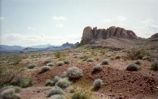
The Mopah Range is a desert mountain range, in the Lower Colorado River Valley region, in southeastern San Bernardino County, California.
The Palo Verde Mountains are a mountain range in northeastern Imperial County, California. They are located along the west side of the Colorado River in the Lower Colorado River Valley and Colorado Desert. Palo Verde Peak, which rises to about 1,800 feet in the southern portion, is the highest point in the area. Thumb Peak stands to the north. Clapp Spring, a palm oasis, is located east of Thumb Peak. Clapp Spring is the only permanent water source in the area for wildlife species.
The Indian Pass Wilderness is 32,418-acre (13,119 ha) wilderness area under the administered by the Bureau of Land Management. The reserve is located in the very southeastern part of the Chocolate Mountains, in the southeastern part of California, just to the west of the Colorado River in the Lower Colorado River Valley. It adjoins the Picacho Peak Wilderness to the south, and the Imperial National Wildlife Refuge to the east.
The Whipple Mountains Wilderness is a 76,122-acre (30,805 ha) wilderness administered by the Bureau of Land Management (BLM). Most of the Whipple Mountains are within the wilderness area. It is located in the northeastern Colorado Desert near the Colorado River. Lake Havasu and Lake Havasu City are 25 miles (40 km) to the North. Earp, California and Parker, Arizona are 20 miles (32 km) to the South. The Parker Dam is 8 miles (13 km) due east.
The Tonopah Desert is a small desert plains region of the Sonoran Desert, located west of Phoenix, Arizona. It is adjacent north of Interstate 10 and lies at the southwest intersection of the Hassayampa River with the Gila River. The Tonopah Desert is also just north of the Gila Bend Mountains massif which create the Gila Bend of the river.
San Felipe Creek is a stream in Imperial and San Diego Counties of California. It arises in the Volcan Mountains of San Diego County 33°11′57″N116°37′35″W, and runs eastward, gathering the waters of most of the eastern slope of the mountains and desert of the county in the San Sebastian Marsh before it empties into the Salton Sea. It is probably the last remaining perennial natural desert stream in the Colorado Desert region. In 1974, the San Felipe Creek Area was designated as a National Natural Landmark by the National Park Service.

Flora of the Colorado Desert, located in Southern California. The Colorado Desert is a sub-region in the Sonoran Desert ecoregion of southwestern North America. It is also known as the Low Desert, in contrast to the higher elevation Mojave Desert or High Desert, to its north.
Gibraltar Mountain Wilderness is a protected wilderness area on the western edge of the Buckskin Mountains in the U.S. state of Arizona. Established in 1990 under the Arizona Desert Wilderness Act the area is managed by the Bureau of Land Management. This desert wilderness is primarily volcanic tuff crossed with deep canyons and sandy washes.
Signal Mountain Wilderness is a protected wilderness area centered around its namesake Signal Mountain, rising 1,200 feet (370 m) to a summit at 2,057 feet (627 m) in the Gila Bend Mountains in the U.S. state of Arizona. Established in 1990 under the Arizona Desert Wilderness Act, the area is managed by the Bureau of Land Management. The desert wilderness is made up of steep canyons, winding arroyos, and volcanic peaks within a Sonoran Desert ecosystem.
Table Top Wilderness is a protected wilderness area centered around its namesake Table Top Mountain, a summit of 4,373 feet in the Table Top Mountains in the U.S. state of Arizona. Established in 1990 under the Arizona Desert Wilderness Act the area is managed by the Bureau of Land Management. It is located in the Sonoran Desert National Monument south of Interstate 8 between the towns of Casa Grande and Gila Bend. The flat-topped mesa rises from the desert floor in Vekol Valley to the east surrounded by smaller canyons and desert washes with views of the desert plain in all directions. There are two established trails in the wilderness area, one of which leads to the summit.
Tres Alamos Wilderness is a protected wilderness area centered around the southern portion of the Black Mountains and the range high point of Sawyer Peak in the U.S. state of Arizona. The namesake feature, Tres Alamos, is a prominent and colorful monolith in the mountains. Established in 1990 under the Arizona Desert Wilderness Act the area is managed by the Bureau of Land Management.
BUzzards Peak Wilderness is a protected wilderness area to the southeast of the Milpitas Wash Wilderness separated by California State Route 78 in Imperial County, California. Established in 2019 by the U.S. Congress, the area is managed by the Bureau of Land Management. Indian Pass Wilderness, Imperial National Wildlife Refuge and the Colorado River are to the south and southeast. Wildlife includes the desert tortoise, Yuma kingsnake, Colorado River toad, Great Plains toad, tree lizard, burros, mule deer and mountain lion. Vegetation found in the area: cholla and beavertail cactus, ocotillo, palo verde, acacia, ironwood, and the rare California Ditaxis.
