Related Research Articles
The Victorian gold rush was a period in the history of Victoria, Australia approximately between 1851 and the late 1860s. It led to a period of extreme prosperity for the Australian colony, and an influx of population growth and financial capital for Melbourne, which was dubbed "Marvellous Melbourne" as a result of the procurement of wealth.

Maytown was the main township on the Palmer River goldfields in Far North Queensland, Australia. It is now a ghost town within locality of Palmer in the Shire of Cook, having been active from c. 1874 to the 1920s. It was added to the Queensland Heritage Register on 1 June 2004.
The mines of the West Coast of Tasmania have a rich historical heritage as well as an important mineralogical value in containing or having had found, specimens of rare and unusual minerals. Also, the various mining fields have important roles in the understanding of the mineralization of the Mount Read Volcanics, and the occurrence of economic minerals.
Tarcoola is a town in the Far North of South Australia 416 kilometres (258 mi) north-northwest of Port Augusta. At the 2016 census, Tarcoola had no people living within its boundaries.

Mining in Australia has long been a significant primary sector industry and contributor to the Australian economy by providing export income, royalty payments and employment. Historically, mining booms have also encouraged population growth via immigration to Australia, particularly the gold rushes of the 1850s. Many different ores, gems and minerals have been mined in the past and a wide variety are still mined throughout the country.

Peak Hill is the name of a goldfield, locality and the site of a gold mining ghost town in the Murchison Region of Western Australia. The gold mine covers 2,162 hectares and consists of four open-cut mines, titled Main, Jubilee, Fiveways and Harmony.
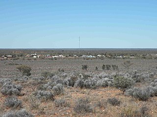
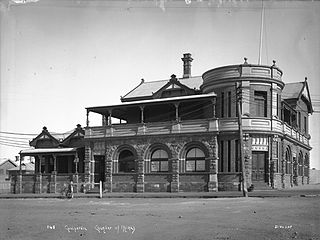
Broad Arrow is a ghost town in Western Australia, located 38 km north of Kalgoorlie and 633 km east of Perth. It is on the Kalgoorlie to Leonora Road.

Gold mining in Western Australia is the third largest commodity sector in Western Australia, behind iron ore and petroleum, with a value of A$11.9 billion.
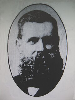
William Henry John Slee, FGS (1836–1907), was an Australian geologist, mines inspector, and mining warden.

During the Australian gold rushes, starting in 1851, significant numbers of workers moved from elsewhere in Australia and overseas to where gold had been discovered. Gold had been found several times before but the colonial government of New South Wales had suppressed the news out of the fear that it would reduce the workforce and so destabilise the economy.

Beria is an abandoned town in the Goldfields-Esperance region of Western Australia, located 8 kilometres (5 mi) north of Laverton on the Laverton-Leonora Road.
Yundamindera, also once known as The Granites, is an abandoned town located between Leonora and Laverton in the Shire of Leonora in the Goldfields-Esperance region of Western Australia.
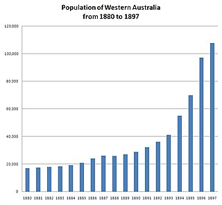
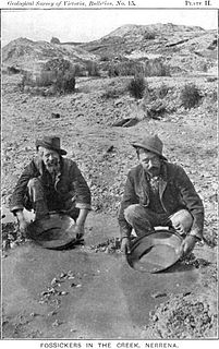
In the latter part of the nineteenth century, discoveries of gold at a number of locations in Western Australia caused large influxes of prospectors from overseas and interstate, and classic gold rushes. Significant finds included:
Mulwarrie is an abandoned town in the North Coolgardie Goldfield of the Goldfields-Esperance region of Western Australia, 125 km northwest of Kalgoorlie, between Davyhurst and Mulline.
State Batteries in Western Australia were government owned and run ore-crushing facilities for the gold mining industry. Western Australia was the only Australian state to provide batteries to assist gold prospectors and small mines. They existed in almost all of the mineral fields of Western Australia.
The Australasian Institute of Mining and Metallurgy (AusIMM) provides services to professionals engaged in all facets of the global minerals sector and is based in Carlton, Victoria, Australia.
New South Wales experienced the first gold rush in Australia, a period generally accepted to lie between 1851 and 1880. This period in the history of New South Wales resulted in a rapid growth in the population and significant boost to the economy of the colony of New South Wales. The California Gold Rush three years prior signaled the impacts on society that gold fever would produce, both positive and negative. The New South Wales colonial government concealed the early discoveries, but various factors changed the policy.
Torrington Blatchford (1871–1938) was an Australian geologist and was Government Geologist in Western Australia from 1929 until 1934.
Western Australia atlas of mineral deposits and petroleum fields is a multiple edition summary of mining and petroleum activity in Western Australia in the twenty-first century.
The Chamber of Minerals and Energy of Western Australia (CME) is a peak business and employers' association in Western Australia (WA).
References
- ↑ "Archived copy" (PDF). Archived from the original (PDF) on 21 July 2008. Retrieved 1 June 2008.CS1 maint: archived copy as title (link) pages 8,9,10
- ↑ (1981) Map of Western Australia showing |Administrative Divisions and principal mines and operators Perth, Department of Mines Administrative divisions list
- ↑ "Greenbushes mineral field". Kalgoorlie Miner . 16 (4630). Western Australia. 3 August 1910. p. 3. Retrieved 8 March 2017– via National Library of Australia.
- ↑ "News and notes". Westralian Worker (1499). Western Australia. 30 July 1937. p. 5. Retrieved 9 March 2017– via National Library of Australia.
- ↑ "Western Australia". Newcastle Morning Herald and Miners' Advocate . XVII (11, 515). New South Wales, Australia. 19 September 1890. p. 6. Retrieved 9 March 2017– via National Library of Australia.
- ↑ "Gascoyne". Western Mail . XIV (677). Western Australia. 16 December 1898. p. 129. Retrieved 9 March 2017– via National Library of Australia.
- ↑ "Collie River coal mining district". Western Mail . XVI (801). Western Australia. 4 May 1901. p. 32. Retrieved 9 March 2017– via National Library of Australia.
- ↑ Catling, Arthur (1899), The Norseman gold belt : Dundas Goldfield, a flourishing West Australian division, description of the mines and country, together with a history of the companies and people : a record of the output of each property, s.n, retrieved 19 April 2012
- ↑ Prebble, F. (Frances) (1979), The historical development of the Phillips River goldfield, Western Australia , retrieved 19 April 2012
- ↑ Ralph, Gilbert M (2007), Bullfinch and the Yilgarn goldfield, Hesperian Press, ISBN 978-0-85905-395-2
- ↑ Playford, Phillip E. (Phillip Elliott); Ruddock, Ian, Discovery of the Kimberley goldfield , retrieved 19 April 2012