The protected areas of the Northern Territory consists of protected areas managed by the governments of the Northern Territory and Australia and private organisations with a reported total area of 335,527 square kilometres (129,548 sq mi) being 24.8% of the total area of the Northern Territory of Australia.

The Purnululu National Park is a World Heritage Site in the East Kimberley region of Western Australia. The 239,723-hectare (592,370-acre) national park is located approximately 300 kilometres (190 mi) south of Kununurra, with Halls Creek located to the south. Declared a World Heritage Site in 2003, the park was inscribed as follows:
...[is a] remote area managed as wilderness. It includes the Bungle Bungle Range, a spectacularly incised landscape of sculptured rocks which contains superlative examples of beehive-shaped karst sandstone rising 250 metres above the surrounding semi-arid savannah grasslands. Unique depositional processes and weathering have given these towers their spectacular black and orange banded appearance, formed by biological processes of cyanobacteria which serve to stabilise and protect the ancient sandstone formations. These outstanding examples of cone karst that have eroded over a period of 20 million years are of great beauty and exceptional geological interest.

The Top End of Australia's Northern Territory is a geographical region encompassing the northernmost section of the Northern Territory, which aside from the Cape York Peninsula is the northernmost part of the Australian continent. It covers a rather vaguely defined area of perhaps 245,000 km2 (94,595 sq mi) behind the northern coast from the Northern Territory capital of Darwin across to Arnhem Land with the Indian Ocean on the west, the Arafura Sea to the north, and the Gulf of Carpentaria to the east, and with the almost waterless semi-arid interior of Australia to the south, beyond the huge Kakadu National Park.

Goyder is an impact structure, the eroded remnant of a former impact crater. It is situated in Arnhem Land in the Northern Territory, Australia, and was named after the nearby Goyder River. The impact occurred into Mesoproterozoic sedimentary rocks of the McArthur Basin. The deformed area is exposed at the surface and marked by a 3 km diameter ring of fractured and faulted sandstone, which is interpreted as the eroded relic of a central uplift ; the original crater rim, long since removed by erosion, being estimated at approximately 9–12 km diameter. Evidence for an impact origin includes the presence of shatter cones and shocked quartz in outcrops of deformed sandstone at the center of the site.

The Sydney Basin is an interim Australian bioregion and is both a structural entity and a depositional area, now preserved on the east coast of New South Wales, Australia and with some of its eastern side now subsided beneath the Tasman Sea. The basin is named for the city of Sydney, on which it is centred.

The Twin Falls is a cascade waterfall on the South Alligator River that descends over the Arnhem Land escarpment within the UNESCO World Heritage–listed Kakadu National Park in the Northern Territory of Australia. The Twin Falls area is registered on the Australian National Heritage List.

Wongalara Sanctuary is a nature reserve in the Top End of the Northern Territory of Australia.
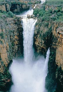
The Jim Jim Falls is a plunge waterfall on the Jim Jim Creek that descends over the Arnhem Land escarpment within the UNESCO World Heritage–listed Kakadu National Park in the Northern Territory of Australia. The Jim Jim Falls area is registered on the Australian National Heritage List.
The Arnhem Land rock rat also known as the Arnhem rock-rat and by the Indigenous Australian name of kodjperr is a species of rodent in the family Muridae. It is found only in the Top End Region of the Northern Territory in Australia.
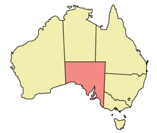
The geography of South Australia incorporates the south central part of the continent of Australia. It is one of the six states of Australia. South Australia is bordered on the west by Western Australia, to the north by the Northern Territory, Queensland to the northeast, and both New South Wales and Victoria to the east. South Australia's south coast is flanked by the Great Australian Bight and the Indian Ocean, although it is referred to locally as the Southern Ocean.

Lubczyna is a village in the administrative district of Gmina Goleniów, within Goleniów County, West Pomeranian Voivodeship, in north-western Poland. It lies approximately 9 kilometres (6 mi) south-west of Goleniów and 13 km (8 mi) north-east of the regional capital Szczecin.

Bodo is a hamlet in central Alberta, Canada within the Municipal District of Provost No. 52. It is located approximately 23 kilometres (14 mi) south of Highway 13 and 254 kilometres (158 mi) east of Red Deer. The community was named after Bodø, Norway.

The Arnhem Plateau, an interim Australian bioregion, is located in the Northern Territory, comprising an area of 2,306,023 hectares of the raised and heavily dissected sandstone plateau that characterises central Arnhem Land in the Top End of the Northern Territory.

Mount Unapproachable is an isolated mountain on the northern side of Lake Neale, in the southwest of Australia's Northern Territory. It is about 505 metres (1,657 ft) above sea level. The area is remote: the nearest towns are Kaltukatjara some 116 kilometres (72 mi) away, Kintore some 135 kilometres (84 mi) away and Yulara 138 kilometres (86 mi) away. The mountain is mostly made of sandstone.

Hann Range is a mountain range in central Australia located approximately 120 kilometres (75 mi) north of Alice Springs in the Northern Territory.
Buckingham River is a river in the Northern Territory of Australia.
The Goromuru River is a river, located in the Northern Territory in Australia.
The Goomadeer River is a river in the Northern Territory, Australia.
The Walker River is a river in the Northern Territory, Australia.