Mitis Seignory

Last updated
Canada Quebec location map 2.svg
Green pog.svg
Mitis Seignory
Mitis Seignory (Quebec)

The Mitis Seignory (French : seigneurie de Mitis) is a forest and wildlife territory located in La Mitis Regional County Municipality in eastern Quebec. It was a seignory during the French colonisation of New France.

French language Romance language

French is a Romance language of the Indo-European family. It descended from the Vulgar Latin of the Roman Empire, as did all Romance languages. French evolved from Gallo-Romance, the spoken Latin in Gaul, and more specifically in Northern Gaul. Its closest relatives are the other langues d'oïl—languages historically spoken in northern France and in southern Belgium, which French (Francien) has largely supplanted. French was also influenced by native Celtic languages of Northern Roman Gaul like Gallia Belgica and by the (Germanic) Frankish language of the post-Roman Frankish invaders. Today, owing to France's past overseas expansion, there are numerous French-based creole languages, most notably Haitian Creole. A French-speaking person or nation may be referred to as Francophone in both English and French.

Quebec Province of Canada

Quebec is one of the thirteen provinces and territories of Canada. It is bordered to the west by the province of Ontario and the bodies of water James Bay and Hudson Bay; to the north by Hudson Strait and Ungava Bay; to the east by the Gulf of Saint Lawrence and the province of Newfoundland and Labrador; and to the south by the province of New Brunswick and the U.S. states of Maine, New Hampshire, Vermont, and New York. It also shares maritime borders with Nunavut, Prince Edward Island, and Nova Scotia. Quebec is Canada's largest province by area and its second-largest administrative division; only the territory of Nunavut is larger. It is historically and politically considered to be part of Central Canada.

Seigneurial system of New France semi-feudal manor system of French Canada

The manorial system of New France was the semi-feudal system of land tenure used in the North American French colonial empire.

Contents

History

The Mitis Seignory was first granted to Jean-Baptiste de Peiras by the New France's governor, Louis de Buade de Frontenac, on May 6, 1675. [1]

Louis de Buade de Frontenac Governor of New France

Louis de Buade, Comte de Frontenac et de Palluau was a French soldier, courtier, and Governor General of New France from 1672 to 1682 and from 1689 to his death in 1698. He established a number of forts on the Great Lakes and engaged in a series of battles against the English and the Iroquois.

The Scottish Mathew MacNider acquired the seignory in 1802 and his brother, John MacNider, bought it in 1807. [2] In fact the MacNider family was the owner of the Mitis Seignory for almost 50 years. [3]

Scotland Country in Europe, part of the United Kingdom

Scotland is a country that is part of the United Kingdom. Sharing a border with England to the southeast, Scotland is otherwise surrounded by the Atlantic Ocean to the north and west, by the North Sea to the northeast and by the Irish Sea to the south. In addition to the mainland, situated on the northern third of the island of Great Britain, Scotland has over 790 islands, including the Northern Isles and the Hebrides.

Territory

At the time of its granting in 1675 the territory of the seignory measured two leagues along the Saint Lawrence River by two leagues away from the river. [4] It is entirely included inside La Mitis Regional County Municipality in Bas-Saint-Laurent.

A league is a unit of length. It was common in Europe and Latin America, but is no longer an official unit in any nation. The word originally meant the distance a person could walk in an hour. Since the Middle Ages, many values have been specified in several countries.

Saint Lawrence River Large river in eastern Canada and the United States, flowing into the Gulf of Saint Lawrence

The Saint Lawrence River is a large river in the middle latitudes of North America. The Saint Lawrence River flows in a roughly north-easterly direction, connecting the Great Lakes with the Atlantic Ocean and forming the primary drainage outflow of the Great Lakes Basin. It traverses the Canadian provinces of Quebec and Ontario, and is part of the international boundary between Ontario, Canada, and the U.S. state of New York. This river provides the basis for the commercial Saint Lawrence Seaway.

Bas-Saint-Laurent Administrative region in Quebec, Canada

The Bas-Saint-Laurent, is an administrative region of Quebec located along the south shore of the lower Saint Lawrence River in Quebec. The river widens at this place, later becoming a bay which discharges into the Atlantic Ocean and is often nicknamed "Bas-du-Fleuve" (Lower-River). The region is formed by 8 regional county municipalities and 114 municipalities. In the south it borders Maine and New Brunswick, as well as the regions of Chaudière-Appalaches and Gaspésie–Îles-de-la-Madeleine

Related Research Articles

La Mitis Regional County Municipality Regional county municipality in Quebec, Canada

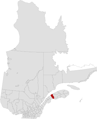
La Mitis is a regional county municipality in the Bas-Saint-Laurent region in eastern Quebec, Canada on the Gaspé peninsula. It is named for the Mitis River which has its source in the region and flows through the central part of the region before emptying into the Saint Lawrence River.

Robert-Cliche Regional County Municipality Regional county municipality in Quebec, Canada

Robert-Cliche is a regional county municipality in the Chaudière-Appalaches region in southeastern Quebec, Canada, on the Chaudière River, between La Nouvelle-Beauce Regional County Municipality and Beauce-Sartigan Regional County Municipality.

Varennes, Quebec City in Quebec, Canada

Varennes is an off-island suburb of Montreal, in southwestern Quebec, Canada, on the Saint Lawrence River in the Marguerite-D'Youville Regional County Municipality. The city is approximately 24 kilometres (15 mi) from Downtown Montreal. The population as of the Canada 2011 Census was 20,994. In 2015, the population is listed at 24,000.

Saint-Liboire, Quebec Municipality in Quebec, Canada

Saint-Liboire is a municipality in the municipalité régionale de comté des Maskoutains in Québec (Canada), located in the administrative region of Montérégie. The population as of the Canada 2011 Census was 3,051.

Métis-sur-Mer, Quebec City in Quebec, Canada

Métis-sur-Mer is a city in the La Mitis Regional County Municipality within the Bas-Saint-Laurent region of Quebec, Canada. It had a population of 607 in the Canada 2011 Census.

Grand-Métis, Quebec Municipality in Quebec, Canada

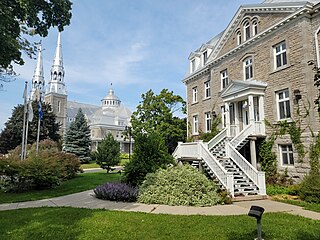
Grand-Métis is a municipality in the La Mitis Regional County Municipality within the Bas-Saint-Laurent region of Quebec, Canada. It is situated where the Mitis River meets the Saint Lawrence River, and was developed from 1818 by the pioneering John MacNider.

LIsle-aux-Coudres Municipality in Quebec, Canada

L'Isle-aux-Coudres is a municipality in Quebec, Canada, in the Charlevoix Regional County Municipality in the Charlevoix area of the Capitale-Nationale region. It is located on and contiguous with Coudres Island, located in the St. Lawrence River about 6 kilometres (3.7 mi) south from the mainland.

Sainte-Anne-de-la-Pérade Municipality in Quebec, Canada

Sainte-Anne-de-la-Pérade is a municipality in the Les Chenaux Regional County Municipality, in the Mauricie region of the province of Quebec in Canada. The town is located near the mouth of the Sainte-Anne River along the Chemin du Roy, a historic segment of Quebec Route 138 that stretches from near Montreal to Quebec City.

Matapedia Valley valley in Quebec, Canada

The Matapedia Valley was formed by the Chic-Choc Mountains of eastern Québec. Its name is derived from the river that traverses the valley, as well as the lake that lies in its center. It is situated in the southwest of the Gaspé Peninsula and stretches 375 km (233 mi).

Saint-Joseph-du-Lac, Quebec Municipality in Quebec, Canada

Saint-Joseph-du-Lac is a municipality in the Laurentides region of Quebec, Canada, part of the Deux-Montagnes Regional County Municipality.

Portneuf, Quebec City in Quebec, Canada

Portneuf is a municipality in the Portneuf Regional County Municipality, in the province of Quebec, Canada. It is located on the Saint Lawrence River, between Quebec City and Trois-Rivières. The Portneuf River runs on the east side of the town centre.

Saint-Joseph-de-Lepage Parish municipality in Quebec, Canada

Saint-Joseph-de-Lepage is a parish municipality in La Mitis Regional County Municipality in the Bas-Saint-Laurent region of Quebec, Canada.

Sainte-Luce, Quebec Municipality in Quebec, Canada

Sainte-Luce is a municipality in the La Mitis Regional County Municipality in the Bas-Saint-Laurent region of Quebec, Canada. The population in the Canada 2011 Census was 2,851.

Les Éboulements Municipality in Quebec, Canada

Les Éboulements is a municipality in the Capitale-Nationale region of Quebec, Canada.

Seignory of Lac-Matapédia

The seignory of Lac-Matapédia is a forest land located on the north shore of Lake Matapédia in the Matapédia Valley in eastern Quebec, Canada. The territory is under a "forest supply and management contract" with the Ministry of Natural Resources and Wildlife (Quebec). It is also the regional park of Lac-Matapédia.

Lessard Seignory (Bas-Saint-Laurent)

The Lessard Seignory was a seignory during the French colonisation of New France. It was located in the present-day Rimouski-Neigette Regional County Municipality in Bas-Saint-Laurent.

Seignory of Bic

The seignory of Bic was a seignory during the French colonisation of New France. It was located in present Rimouski-Neigette Regional County Municipality in Bas-Saint-Laurent.

Seignory of Lac-Mitis

The seignory of Lac-Mitis was a seignory during the French colonisation of New France. It was located in present-day La Mitis Regional County Municipality in Bas-Saint-Laurent. It was granted to Louis Rouer de Villeray by Louis de Buade de Frontenac, the governor of New France, on February 10, 1693.

Madawaska Seignory

The Madawaska Seignory was a seignory during the French colonisation of New France. It was located in present-day Témiscouata Regional County Municipality in Bas-Saint-Laurent.

Seignory of Rimouski

The Rimouski Seignory was a seignory during the French colonisation of New France. It was located in the present-day Rimouski-Neigette Regional County Municipality in Bas-Saint-Laurent, Quebec.

References

  1. Gouvernement du Québec. "Seigneurie de Mitis". Commission de toponymie du Québec (in French). Retrieved May 1, 2013.
  2. Gouvernement du Québec. "MacNider". Commission de toponymie du Québec (in French). Retrieved August 1, 2013.
  3. Comité du centenaire de Saint-Damase (1984). Centenaire de Saint-Damase 1884-1984 (in French). Matane, Quebec: Comité du centenaire de Saint-Damase. p. 25. ISBN   2-9800328-0-8.
  4. Courville, Serge; Labrecque, Serge (1988). Seigneuries et fiefs du Québec : nomenclature et cartographie (in French). Quebec City, Quebec: Faculté des Lettres de l'Université Laval (CÉLAT). p. 158. ISBN   2-920576-22-4.

Coordinates: 48°37′00″N68°00′00″W / 48.6167°N 68.0000°W / 48.6167; -68.0000

Geographic coordinate system Coordinate system

A geographic coordinate system is a coordinate system that enables every location on Earth to be specified by a set of numbers, letters or symbols. The coordinates are often chosen such that one of the numbers represents a vertical position and two or three of the numbers represent a horizontal position; alternatively, a geographic position may be expressed in a combined three-dimensional Cartesian vector. A common choice of coordinates is latitude, longitude and elevation. To specify a location on a plane requires a map projection.