There are twenty-two districts of Libya, known by the term shabiyah. In the 1990s these replaced the older baladiyat system.

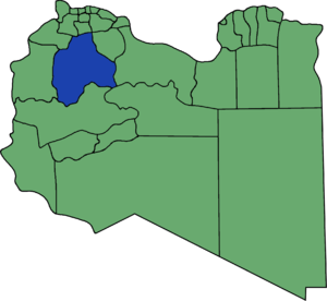
Nuqat al Khams is one of the districts of Libya. It is in the northwest of the country, in what had been the historical region of Tripolitania. Its capital is Zuwara. In the north, Nuqat al Khams has a shoreline on the Mediterranean Sea. To the west, it borders the Medenine Governorate of Tunisia. Domestically, it borders the following districts, namely, Zawiya in east, Jabal al Gharbi in southeast and Nalut in the southwest. Nuqat al Khams is a part of the Tripolitania geographical region of Libya.

Ghadames or Ghadamis was a district of Libya until 2007. Its territory is now part of Nalut District. It was in the northwest of the country with its capital at Ghadames.
Gharyan District or Garian District was one of the districts of Libya. It was located in the northwest part of the country and its capital was Gharyan. Under the 2007 reorganization of districts, it became part of Jabal al Gharbi District.

Yafran or Yifren was formerly one of the districts of Libya. It was located in the northwest part of the country and its capital was Yafran. Under the 2007 reorganization of districts, most of it became part of Jabal al Gharbi District, while the southwestern part went to Nalut District.

Sabratha wa Sorman was one of the districts of Libya from 1998 to 2007, in the Northwest. Since 2007 the area has been part of Zawiya District.
Wadi al Shati, sometimes referred to as Ashati, is one of the districts of Libya in the central-west part of the country. The area is mostly desert. Wadi al Shati District is named after the depression of the same name, Wadi Ashati.

Bani Walid or Ben Walid, prior to 2007, was one of the districts of Libya, administrative town Bani Walid. In the 2007 administrative reorganization the territory formerly in Bani Walid District was transferred to Misrata District.

Nalut is one of the districts of Libya. Its capital is the city of Nalut. The second most notable city is Ghadames. To the north and west, Nalut district borders Tunisia and Algeria. Domestically, it borders Nuqat al Khams - northeast, Jabal al Gharbi in the east and Wadi al Shatii in south. In 2007, Nalut District was enlarged to include the Ghadames District, while the eastern part of former Nalut was moved to Jabal al Gharbi.

Tajura, also spelt Tajoura, is a town in north-western Libya, and baladiyah in the Tripoli Muhafazah, on the Mediterranean coast 23 kilometres (14 mi) east of Tripoli.

Yafran, also spelled Jefren, Yefren, Yifran, Yifrin or Ifrane, is a city in northwestern Libya, in the yefren District in the western Nafusa Mountains. Before 2007, Yafran was the administrative seat of the Yafran District.

The Nafusa Mountains are a mountain range in the western Tripolitania region of northwestern Libya. It also includes their regions around the escarpment formed where the northern end of the Tripolitanian Plateau meets the Mediterranean coastal plain or the Jefara.
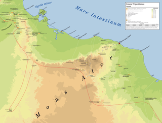
The Limes Tripolitanus was a frontier zone of defence of the Roman Empire, built in the south of what is now Tunisia and the northwest of Libya. It was primarily intended as a protection for the tripolitanian cities of Leptis Magna, Sabratha and Oea in Roman Libya.

al-Mazra'a ash-Sharqiya is a Palestinian town in the Ramallah and al-Bireh Governorate, located northeast of Ramallah in the northern West Bank. According to the Palestinian Central Bureau of Statistics (PCBS), the town had a population of approximately 4,495 inhabitants in 2007.

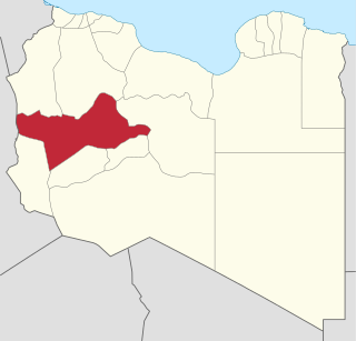
Jabal al Gharbi is one of the districts of Libya. It is named after the Nafusa Mountains. It was formed in 2007 from the former districts of Yafran, Gharyan and Mizda. From 1995 to 1998 Jabal al Gharbi also existed as a Baladiyah. Jabal al Gharbi borders Sirte and Misrata to the east, Murqub to the northeast, Jafara and Zawiya to the north, Nuqat al Khams to the northwest, Nalut to the west, Tripoli to the north, Wadi al Shatii to the south and Jufra to the southeast.
Mizda or Mesdah is a town in the Nafusa Mountains in Libya. It was the capital of the former Mizda District.

Jabal al Gharbi Governorate or Jebal al Gharbi Governorate was one of the governorates (muhafazah) of Libya from 1963 to 1983. Its capital was Gharian. Other important towns in the governorate were Yafran, Nalut, Ghadames and Mizda.
The 2011 Nafusa Mountains campaign was a series of battles in the Libyan Civil War, fought between loyalist pro-Gaddafi forces and rebel anti-Gaddafi forces in the Nafusa Mountains and, at a later period, in the surrounding plains of western Libya. The mountain range is of strategic importance due to its close proximity to the capital of Tripoli. Along with the city of Misrata, the Nafusa Mountains region was one of the major rebel strongholds in Tripolitania.
ʿAyn al Ghazaya is a village in Nalut District in northwestern Libya. It lies on a crossroads on the Wazzin–Nalut road on the northern edge of the Tripolitanian Plateau in the Nafusa Mountains.
Nasmah is a settlement in the former Mizda district of Libya. The village is at 31° 23' N, 13° 17' E. The tribe that populates the area is known as the "Awlad Abu seif".