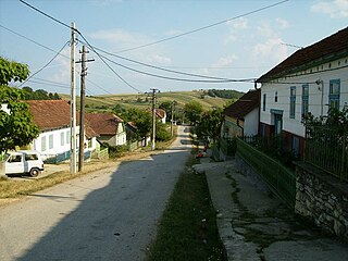
Mišljenovac

Last updated
Mišljenovac
Мишљеновац
Village
Serbia adm location map.svg
Red pog.svg
Mišljenovac
Coordinates: 44°32′N21°34′E / 44.533°N 21.567°E / 44.533; 21.567
CountryFlag of Serbia.svg  Serbia
District Braničevo District
Municipality Kučevo
Population (2002)
  Total 465
Time zone CET (UTC+1)
  Summer (DST) CEST (UTC+2)

Mišljenovac is a village in the municipality of Kučevo, Serbia. According to the 2002 census, the village has a population of 465 people. [1]

Village Small clustered human settlement smaller than a town

A village is a clustered human settlement or community, larger than a hamlet but smaller than a town, with a population ranging from a few hundred to a few thousand. Though villages are often located in rural areas, the term urban village is also applied to certain urban neighborhoods. Villages are normally permanent, with fixed dwellings; however, transient villages can occur. Further, the dwellings of a village are fairly close to one another, not scattered broadly over the landscape, as a dispersed settlement.

Kučevo Town and municipality in Southern and Eastern Serbia, Serbia

Kučevo is a town and municipality located in the Braničevo District of the eastern Serbia. In 2011, the population of the town was 3,950, while the population of the municipality was 15,490.

Serbia Republic in Southeastern Europe

Serbia, officially the Republic of Serbia, is a country situated at the crossroads of Central and Southeast Europe in the southern Pannonian Plain and the central Balkans. The sovereign state borders Hungary to the north, Romania to the northeast, Bulgaria to the southeast, North Macedonia to the south, Croatia and Bosnia and Herzegovina to the west, and Montenegro to the southwest. The country claims a border with Albania through the disputed territory of Kosovo. Serbia's population is about seven million. Its capital, Belgrade, ranks among the oldest and largest citiеs in southeastern Europe.

Related Research Articles

El Forn Place in Canillo, Andorra

El Forn is a village in Andorra, Europe, located in the parish of Canillo.

Vila, Andorra Place in Encamp, Andorra

Vila is a village in Andorra, located in the parish of Encamp.

Sornàs Place in Ordino, Andorra

Sornàs is a village in Andorra, located in the parish of Ordino.

Ciulnița is a commune located in Ialomița County, Romania. It is composed of four villages: Ciulnița, Ion Ghica, Ivănești and Poiana.

Șepreuș Commune in Arad County, Romania

Șepreuș is a commune in Arad County, Romania, is situated on the northern part of the Teuz Plateau, it stretches over 5768 ha. It is composed of a single village, Șepreuș, situated at 63 km from Arad.

Făurești Commune in Vâlcea County, Romania

Făurești is a commune located in Vâlcea County, Romania. It is composed of five villages: Bungețani, Făurești, Găinești, Mărcușu and Milești. It also included the villages of Băbeni-Oltețu, Budești, Colelia and Diculești until 2004, when these were split off to form Diculești Commune.

Gârnic Commune in Caraș-Severin County, Romania

Gârnic is a commune in Caraș-Severin County, western Romania with a population of 1,533 people. It is composed of two villages, Gârnic and Padina Matei (Mátévölgye).

Melinești Commune in Dolj County, Romania

Melinești is a commune in Dolj County, Romania with a population of 4,392 people. It is composed of thirteen villages: Bodăiești, Bodăieștii de Sus, Godeni, Melinești, Muierușu, Negoiești, Odoleni, Ohaba, Ploștina, Popești, Spineni, Valea Mare and Valea Muierii de Jos.

Băbiciu Commune in Olt County, Romania

Băbiciu is a commune in Olt County, Romania. It is composed of a single village, Băbiciu.

Gostavățu Commune in Olt County, Romania

Gostavățu is a commune in Olt County, Romania. It is composed of two villages, Gostavățu and Slăveni.

Dăneasa Commune in Olt County, Romania

Dăneasa is a commune in Olt County, Romania. It is composed of five villages: Berindei, Cioflanu, Dăneasa, Pestra and Zănoaga.

Strejești Commune in Olt County, Romania

Strejești is a commune in Olt County, Romania. It is composed of four villages: Colibași, Mamura, Strejești and Strejeștii de Sus.

Bozbinə Place in Zaqatala, Azerbaijan

Bozbinə is a village in the Zaqatala Rayon of Azerbaijan. The village forms part of the municipality of Dombabinə.

Khopasi is a village development committee in Kabhrepalanchok District in the Bagmati Zone of central Nepal. At the time of the 1991 Nepal census it had a population of 3453 in 676 individual households.

Bogoria, Sandomierz County Village in Świętokrzyskie, Poland

Bogoria is a village in the administrative district of Gmina Łoniów, within Sandomierz County, Świętokrzyskie Voivodeship, in south-central Poland. It lies approximately 5 kilometres (3 mi) south-east of Łoniów, 22 km (14 mi) south-west of Sandomierz, and 78 km (48 mi) south-east of the regional capital Kielce.

Kielcza Village in Opole, Poland

Kielcza is a village in the administrative district of Gmina Zawadzkie, within Strzelce County, Opole Voivodeship, Upper Silesia in south-western Poland. It lies approximately 7 kilometres (4 mi) south-east of Zawadzkie, 20 km (12 mi) north-east of Strzelce Opolskie, and 44 km (27 mi) east of the regional capital Opole.

Radomek, Warmian-Masurian Voivodeship Village in Warmian-Masurian, Poland

Radomek is a village in the administrative district of Gmina Iława, within Iława County, Warmian-Masurian Voivodeship, in northern Poland. It lies approximately 4 kilometres (2 mi) south-west of Iława and 69 km (43 mi) west of the regional capital Olsztyn.

Kalajevo (Lukavac) Village in Lukavac, Bosnia and Herzegovina

Kalajevo (Lukavac) is a village in the municipality of Lukavac, Bosnia and Herzegovina.

Bresnik (Kraljevo) Village in Raška District, Serbia

Bresnik is a village in the municipality of Kraljevo, western-central Serbia. According to the 2002 census, the village has a population of 184 people.

Nà Hỳ is a commune () and village of the Mường Nhé District of Điện Biên Province, northwestern Vietnam.

References

  1. Popis stanovništva, domaćinstava i Stanova 2002. Knjiga 1: Nacionalna ili etnička pripadnost po naseljima. Republika Srbija, Republički zavod za statistiku Beograd 2003. ISBN   86-84433-00-9

Coordinates: 44°32′N21°34′E / 44.533°N 21.567°E / 44.533; 21.567

Geographic coordinate system Coordinate system

A geographic coordinate system is a coordinate system that enables every location on Earth to be specified by a set of numbers, letters or symbols. The coordinates are often chosen such that one of the numbers represents a vertical position and two or three of the numbers represent a horizontal position; alternatively, a geographic position may be expressed in a combined three-dimensional Cartesian vector. A common choice of coordinates is latitude, longitude and elevation. To specify a location on a plane requires a map projection.