
Kaumakani is a census-designated place (CDP) in Kauaʻi County, Hawaiʻi, United States. The population was 749 at the 2010 census, up from 607 at the 2000 census.

Springview is a village in, and the county seat of, Keya Paha County, Nebraska. The population was 242 at the 2010 census.

Woodbury is a town in Cannon County, Tennessee, United States. Woodbury is part of the Nashville Metropolitan Statistical Area and is located 55 miles (89 km) southeast of downtown Nashville. The population of Woodbury was 2,680 at the 2010 census. It is the county seat of Cannon County.
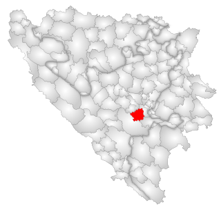
Hadžići is a town and a municipality located in Sarajevo Canton of the Federation of Bosnia and Herzegovina, an entity of Bosnia and Herzegovina. It is located south west of the city of Sarajevo. According to the census of 2013, Hadžići municipality has a population of 23,891 residents.

Philmont is a village in Columbia County, New York, United States. The population was 1,379 at the 2010 census. The village is located in the northeast part of the town of Claverack on New York State Route 217.
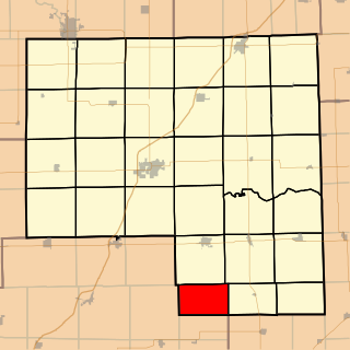
Belle Prairie Township is located in Livingston County, Illinois in the United States. As of the 2010 census, its population was 135 and it contained 55 housing units.

Ball Township is located in Sangamon County, Illinois. As of the 2010 census, its population was 6,701 and it contained 2,403 housing units.

Mmeya is a village in Central District of Botswana. It is located 60 km west of Francistown. The village has a primary school and the population was 556 in 2001 census.

Korchów Drugi is a village in the administrative district of Gmina Księżpol, within Biłgoraj County, Lublin Voivodeship, in eastern Poland. It lies approximately 9 kilometres (6 mi) south-east of Księżpol, 22 km (14 mi) south of Biłgoraj, and 100 km (62 mi) south of the regional capital Lublin.
Janinów is a village in the administrative district of Gmina Rokiciny, within Tomaszów Mazowiecki County, Łódź Voivodeship, in central Poland. It lies approximately 20 kilometres (12 mi) north-west of Tomaszów Mazowiecki and 30 km (19 mi) south-east of the regional capital Łódź.
Rakoszyn is a village in the administrative district of Gmina Nagłowice, within Jędrzejów County, Świętokrzyskie Voivodeship, in south-central Poland. It lies approximately 5 kilometres (3 mi) south-west of Nagłowice, 16 km (10 mi) west of Jędrzejów, and 47 km (29 mi) south-west of the regional capital Kielce.
Wierzbie is a village in the administrative district of Gmina Pierzchnica, within Kielce County, Świętokrzyskie Voivodeship, in south-central Poland. It lies approximately 8 kilometres (5 mi) south-east of Pierzchnica and 30 km (19 mi) south-east of the regional capital Kielce.
Życiny is a village in the administrative district of Gmina Raków, within Kielce County, Świętokrzyskie Voivodeship, in south-central Poland. It lies approximately 4 kilometres (2 mi) south-west of Raków and 39 km (24 mi) south-east of the regional capital Kielce.
Łucjanowo is a village in the administrative district of Gmina Wronki, within Szamotuły County, Greater Poland Voivodeship, in west-central Poland. It lies approximately 9 kilometres (6 mi) south-west of Wronki, 21 km (13 mi) west of Szamotuły, and 51 km (32 mi) north-west of the regional capital Poznań.
Jałowiec is a village in the administrative district of Gmina Ryjewo, within Kwidzyn County, Pomeranian Voivodeship, in northern Poland. It lies approximately 3 kilometres (2 mi) south-west of Ryjewo, 10 km (6 mi) north of Kwidzyn, and 64 km (40 mi) south of the regional capital Gdańsk.
Wilcze Błota is a village in the administrative district of Gmina Lubichowo, within Starogard County, Pomeranian Voivodeship, in northern Poland. It lies approximately 5 kilometres (3 mi) south of Lubichowo, 19 km (12 mi) south-west of Starogard Gdański, and 63 km (39 mi) south of the regional capital Gdańsk.
Mortąg is a village in the administrative district of Gmina Stary Dzierzgoń, within Sztum County, Pomeranian Voivodeship, in northern Poland. It lies approximately 3 kilometres (2 mi) south-east of Stary Dzierzgoń, 29 km (18 mi) east of Sztum, and 80 km (50 mi) south-east of the regional capital Gdańsk.
Nicponia is a village in the administrative district of Gmina Gniew, within Tczew County, Pomeranian Voivodeship, in northern Poland. It lies approximately 2 kilometres (1 mi) south-west of Gniew, 32 km (20 mi) south of Tczew, and 62 km (39 mi) south of the regional capital Gdańsk.
Zawierz is a village in the administrative district of Gmina Braniewo, within Braniewo County, Warmian-Masurian Voivodeship, in northern Poland, close to the border with the Kaliningrad Oblast of Russia. It lies approximately 3 kilometres (2 mi) south of Braniewo and 77 km (48 mi) north-west of the regional capital Olsztyn.

Greben is a village in the municipality of Višegrad, Bosnia and Herzegovina.


