The Bosnian-Podrinje Canton Goražde is one of ten cantons of the Federation of Bosnia and Herzegovina, an entity in Bosnia and Herzegovina.

Jankowice is a village in the administrative district of Gmina Oława, within Oława County, Lower Silesian Voivodeship, in south-western Poland. Prior to 1945 it was in Germany.
Mielęcin is a village in the administrative district of Gmina Żarów, within Świdnica County, Lower Silesian Voivodeship, in south-western Poland. Prior to 1945 it was Pfaffendorf in Germany.
Nowe Gagowy is a village in the administrative district of Gmina Lubień Kujawski, within Włocławek County, Kuyavian-Pomeranian Voivodeship, in north-central Poland. It lies approximately 4 kilometres (2 mi) north-east of Lubień Kujawski, 26 km (16 mi) south of Włocławek, and 78 km (48 mi) south-east of Toruń.
Marcinkowo is a village in the administrative district of Gmina Mogilno, within Mogilno County, Kuyavian-Pomeranian Voivodeship, in north-central Poland.
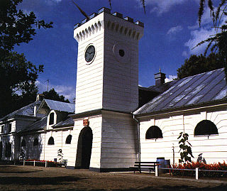
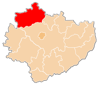
Janów Podlaski is a town in Biała Podlaska County, Lublin Voivodeship, in eastern Poland, close to the border with Belarus. It is the seat of the gmina called Gmina Janów Podlaski. It lies approximately 20 kilometres (12 mi) north of Biała Podlaska and 115 km (71 mi) north-east of the regional capital Lublin. The town has a population of 2700.
Maszów Górny is a village in the administrative district of Gmina Rudnik, within Krasnystaw County, Lublin Voivodeship, in eastern Poland.
Rzeczyca Ziemiańska-Kolonia is a village in the administrative district of Gmina Trzydnik Duży, within Kraśnik County, Lublin Voivodeship, in eastern Poland.
Żeleźnica is a village in the administrative district of Gmina Przedbórz, within Radomsko County, Łódź Voivodeship, in central Poland. It lies approximately 14 kilometres (9 mi) south-east of Przedbórz, 41 km (25 mi) east of Radomsko, and 97 km (60 mi) south-east of the regional capital Łódź.
Szczepanowice is a village in the administrative district of Gmina Słomniki, within Kraków County, Lesser Poland Voivodeship, in southern Poland. It lies approximately 7 kilometres (4 mi) south of Słomniki and 20 km (12 mi) north-east of the regional capital Kraków.
Łętkowice-Kolonia is a village in the administrative district of Gmina Radziemice, within Proszowice County, Lesser Poland Voivodeship, in southern Poland.

Mnin is a village in the administrative district of Gmina Słupia Konecka, within Końskie County, Świętokrzyskie Voivodeship, in south-central Poland. It lies approximately 5 kilometres (3 mi) south-east of Słupia, 29 km (18 mi) south-west of Końskie, and 33 km (21 mi) west of the regional capital Kielce.
Mnin-Przymusów, also known as Przymusów, is a settlement in the administrative district of Gmina Słupia Konecka, within Końskie County, Świętokrzyskie Voivodeship, in south-central Poland.
Mnin-Szwedy, also known as Szwedy, is a settlement in the administrative district of Gmina Słupia Konecka, within Końskie County, Świętokrzyskie Voivodeship, in south-central Poland.
Kotarszyn is a village in the administrative district of Gmina Waśniów, within Ostrowiec County, Świętokrzyskie Voivodeship, in south-central Poland. It lies approximately 5 kilometres (3 mi) north-west of Waśniów, 15 km (9 mi) west of Ostrowiec Świętokrzyski, and 42 km (26 mi) east of the regional capital Kielce.
Pęcław is a village in the administrative district of Gmina Góra Kalwaria, within Piaseczno County, Masovian Voivodeship, in east-central Poland. It lies approximately 5 kilometres (3 mi) south of Góra Kalwaria, 20 km (12 mi) south-east of Piaseczno, and 35 km (22 mi) south-east of Warsaw.
Nowe Bulkowo is a village in the administrative district of Gmina Winnica, within Pułtusk County, Masovian Voivodeship, in east-central Poland.
Karwieńskie Błoto Drugie is a village in the administrative district of Gmina Krokowa, within Puck County, Pomeranian Voivodeship, in northern Poland. It lies approximately 6 kilometres (4 mi) north-east of Krokowa, 19 km (12 mi) north-west of Puck, and 58 km (36 mi) north-west of the regional capital Gdańsk.