Modalen is a municipality in the Nordhordland district in the central part of Vestland county in Norway. The administrative centre of the municipality is the village of Mo. The other main village in the municipality is Øvre Helland. Most of the residents of Modalen live in the main Modalen valley which extends eastwards from the end of the Romarheimsfjorden.

Masfjorden is a municipality in the central part of Vestland county in Norway. The municipality is located in the Nordhordland district of the county. The administrative centre of the municipality is the village of Masfjordnes. Other villages in the municipality include Frøyset, Hosteland, Matre, and Solheim.

Bremanger is a municipality in Vestland county, Norway. The village of Svelgen is the administrative centre of the municipality. Other villages include Bremanger, Berle, Davik, Isane, Kalvåg, Svelgen, Rugsund, and Ålfoten. Bremanger is the only municipality in Vestland, which is located in two districts. The northern and eastern parts comprising the villages of Oldeide, Berle, Rugsund, Davik, Isane, and Ålfoten is located in the Nordfjord region, while the villages of Bremanger, Kalvåg, Svelgen, Sørgulen, and Botnane are located in the Sunnfjord region. Politically, the municipality works with the Nordfjord region in the council of Nordfjord municipalities.

Stryn is a municipality in the county of Vestland, Norway. It is located in the traditional district of Nordfjord. The administrative center of the municipality is the village of Stryn. The municipality is located along the innermost part of the Nordfjorden. Some of the main villages in Stryn include Loen, Innvik, Utvik, Randabygda, Olden, and Flo.
Leirvik is a town and the administrative centre of Stord municipality in Vestland county, Norway. The town lies along the southern coast of the large island of Stord, along the Hardangerfjorden. The town gained "town status" in 1997. The town includes the Eldøyane peninsula where the large Kværner Stord industrial area is located.

Årdalstangen is the administrative centre of Årdal Municipality in Vestland county, Norway. The village is one of the two main population centers in the municipality, along with the village of Øvre Årdal. The 1.12-square-kilometre (280-acre) village has a population (2019) of 1,375 and a population density of 1,228 inhabitants per square kilometre (3,180/sq mi).

Nordhordland is a traditional district in the western part of Norway. The district consists of the northern portion of the old Hordaland county, north of the city of Bergen. It includes the municipalities Alver, Austrheim, Fedje, Masfjorden, Modalen, Osterøy, and Vaksdal. The district roughly corresponds to the Nordhordland prosti, a Church of Norway deanery and also to the municipalities that fall under the Nordhordland District Court. Historically, the municipality of Gulen to the north was included in the district.

Knarvik is the administrative centre of the municipality of Alver in Vestland county, Norway. The village is located on the mainland, about 20 km (12 mi) straight north of Bergen at the confluence of four fjords: Osterfjorden, Sørfjorden, Salhusfjorden, and the Radfjorden. The village of Isdalstø lies immediately north of Knarvik.

Korgen is the administrative centre of Hemnes Municipality in Nordland county, Norway. The village located along the river Røssåga, about 8 kilometres (5.0 mi) south of the village of Bjerka. Korgen is connected by the European route E6 highway to the nearby towns of Mo i Rana and Mosjøen. The eastern end of the Korgfjell Tunnel is located in Korgen. The village of Bleikvassli lies about 20 kilometres (12 mi) to the south along the Norwegian County Road 806. The 0.9-square-kilometre (220-acre) village has a population (2017) of 878 which gives the village a population density of 976 inhabitants per square kilometre (2,530/sq mi). This makes it the largest urban area in the municipality.
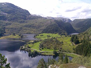
Steinslandsvatnet is a lake in the municipality of Modalen in Vestland county, Norway. The 2.4-square-kilometre (0.93 sq mi) lake is the headwaters of the river Moelva in the center of the Modalen valley. The village of Øvre Helland lies at the southern end of the lake. The Norwegian county road 345 runs along the western shoreline of the lake.

Hosanger is a former municipality in the old Hordaland county, Norway. The municipality existed from 1838 until its dissolution in 1964. The municipality was located in what is now parts of Alver Municipality and Osterøy Municipality in Vestland county. It originally covered all the lands on both sides of the Osterfjorden-Romarheimsfjorden from the Lonevågen fjord all the way east to the county border at the end of the Modalen valley. Hosanger also included an exclave on the Lindås peninsula surrounding the village of Seim at the southern end of the Lurefjorden. Seim was separated from the rest of Hosanger by part of Lindås Municipality. Over time, the areas of Seim and Modalen were split off from Hosanger. The administrative centre of the municipality was the village of Hosanger on the island of Osterøy, where Hosanger Church is located.
Flatkvål /fla:kol/ is a village in the Eksingedalen valley in Vaksdal municipality, Vestland county, Norway. The village lies along the river Storelvi, about 30 kilometres (19 mi) northeast of the village of Stamneshella. The Modalen Tunnel is located about 5 kilometres (3.1 mi) west of Flatkvål. The village of Nesheim lies about 15 kilometres (9.3 mi) to the east. Flatkvål is the site of Eksingedal Church.

Bremangerlandet is an island in Bremanger Municipality in the traditional district of Nordfjord in Vestland county, Norway. The 153-square-kilometre (59 sq mi) island is one of the largest islands in the county. The highest point on the island is the 889-metre (2,917 ft) tall mountain Svartevassegga, however the cliff at Hornelen, located 1 kilometre (0.62 mi) to the east, is more well-known and has an elevation of 860 metres (2,820 ft). The 4-kilometre (2.5 mi) long lake Dalevatnet is located in the central part of the island.
Eksingedalen or Eksingadalen is a valley that makes up the northeastern part of Vaksdal Municipality in Vestland County, Norway.

Vågsøy is an island in Kinn Municipality in Vestland county, Norway. The 59.1-square-kilometre (22.8 sq mi) island lies on the northern side of the mouth of the Nordfjorden, the sixth longest fjord in Norway. The Stadlandet peninsula lies to the north of the island, the islands of Silda and Barmøya and the mainland lie to the east of the island, the island of Husevågøy lies to the south, and the open ocean lies to the west. Since the island lies along the open ocean, which can be rough, there are several lighthouses along the coastline of the island including: Hendanes Lighthouse, Kråkenes Lighthouse, and Skongenes Lighthouse. The highest point on the island is the 613-metre (2,011 ft) tall Veten.
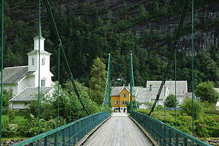
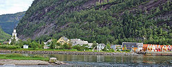
Mo Church is a parish church of the Church of Norway in Modalen Municipality in Vestland county, Norway. It is located in the village of Mo. It is the church for the Mo parish which is part of the Nordhordland prosti (deanery) in the Diocese of Bjørgvin. The white, wooden, neo-gothic church was built in a long church design in 1883 using plans drawn up by the architect Johannes Øvsthus. The church seats about 220 people.

Romarheimsfjorden is a fjord in Vestland county, Norway. The fjord flows through the municipalities of Modalen, Alver, and Osterøy. The western end of the fjord lies near the island of Hokøy where the fjord flows in to the Osterfjorden on its way out to sea. The fjord extends eastward from Hokøy for 11 kilometres (6.8 mi) along the border of Alver and Osterøy municipalities before entering Modalen where it continues to the Mostraumen, a 60-metre (200 ft) wide channel that is 650 metres (2,130 ft) long. On the other side of the channel, the fjord continues for another 18 kilometres (11 mi) where it is usually called the Mofjorden. That fjord ends at the village of Mo.

Evanger is a village in the municipality of Voss in Vestland county, Norway. The village lies in western Voss at the eastern end of the lake Evangervatnet where the river Vosso empties into the lake. Evanger sits about 20 kilometres (12 mi) west of the municipal centre of Vossevangen.
Valevåg is a village in Sveio municipality in Vestland county, Norway. The village is located on the northern end of the Sveio peninsula, along the southern shore of the Hardangerfjorden. Historically, Valevåg was the administrative centre of the old municipality of Valestrand until it was merged into Sveio in 1964. Valen Chapel is in the village of Valevåg, and just outside the village to the south is the much larger Valestrand Church.

Stad is a municipality in Vestland county, Norway. It is located in the traditional district of Nordfjord. The municipality includes much of the northern shore of the Nordfjorden as well as the Stad peninsula. The administrative centre of the municipality is the village of Nordfjordeid. Other villages in the municipality include Selje, Barmen, Ervik, Flatraket, Hoddevik, Hoddevika, Håvik, Leikanger, Mogrenda, Stårheim, Haugen, Kjølsdalen, Heggjabygda, and Lote.