A mobile form is an electronic or digital form application that functions on a smartphone or tablet device. Mobile forms enable users to collect data using mobile devices, and then to send the results back to the source. Mobile forms exist to replace paper forms as a more productive means of data collection, eliminating the need to transcribe or scan paper data results into a back office system.
Depending on the mobile formapplication provider, some mobile form solutions allow offices to dispatch data to mobile form applications. In addition, other mobile form applications can be connected with various cloud services, servers, and social media platforms.
Depending on the business, the motivating factors to deploying mobile forms may vary. Some businesses implement mobile forms to speed up processes, while others institute mobile forms with field users to reduce costs associated with transporting paper forms back and forth. Furthermore, green-minded businesses implement mobile forms in order to be more environmentally friendly, thus reducing their reliance on paper, ink printing, and subsequent waste.
Advanced mobile form features include signature capture, bar code capture, photo capture, GPS location form info, time form info, and skip logic.[citation needed]
Location-based Mobile Forms
Location-based mobile forms are applications that associate a specific GPS location to the form data. Theses types of application fall into the category of data collection systems and are used by field personnel to collect data at precise locations in the field. Data collected with these applications is georeferenced and is can be transferred to geographic information systems for further data analysis. Location-based mobile forms act as a bridge between field personnel and geomatics specialists.
A location-based service (LBS) is a general term denoting software services which utilize geographic data and information to provide services or information to users. LBS can be used in a variety of contexts, such as health, indoor object search, entertainment, work, personal life, etc. Commonly used examples of location based services include navigation software, social networking services, location-based advertising, and tracking systems. LBS can also include mobile commerce when taking the form of coupons or advertising directed at customers based on their current location. They include personalized weather services and even location-based games.
XForms is an XML format used for collecting inputs from web forms. XForms was designed to be the next generation of HTML / XHTML forms, but is generic enough that it can also be used in a standalone manner or with presentation languages other than XHTML to describe a user interface and a set of common data manipulation tasks.
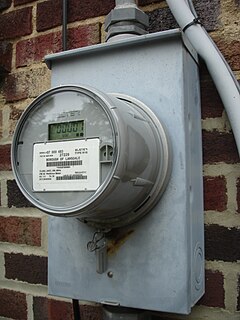
Automatic meter reading (AMR) is the technology of automatically collecting consumption, diagnostic, and status data from water meter or energy metering devices and transferring that data to a central database for billing, troubleshooting, and analyzing. This technology mainly saves utility providers the expense of periodic trips to each physical location to read a meter. Another advantage is that billing can be based on near real-time consumption rather than on estimates based on past or predicted consumption. This timely information coupled with analysis can help both utility providers and customers better control the use and production of electric energy, gas usage, or water consumption.
In the context of information security, and especially network security, a spoofing attack is a situation in which a person or program successfully identifies as another by falsifying data, to gain an illegitimate advantage.
Mobile computing is human–computer interaction in which a computer is expected to be transported during normal usage, which allows for the transmission of data, voice, and video. Mobile computing involves mobile communication, mobile hardware, and mobile software. Communication issues include ad hoc networks and infrastructure networks as well as communication properties, protocols, data formats, and concrete technologies. Hardware includes mobile devices or device components. Mobile software deals with the characteristics and requirements of mobile applications.
Telematics is an interdisciplinary field that encompasses telecommunications, vehicular technologies, electrical engineering, and computer science. Telematics can involve any of the following:
Automatic identification and data capture (AIDC) refers to the methods of automatically identifying objects, collecting data about them, and entering them directly into computer systems, without human involvement. Technologies typically considered as part of AIDC include QR codes, bar codes, radio frequency identification (RFID), biometrics, magnetic stripes, optical character recognition (OCR), smart cards, and voice recognition. AIDC is also commonly referred to as "Automatic Identification", "Auto-ID" and "Automatic Data Capture".
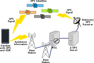
Assisted GNSS (A-GNSS) is a GNSS augmentation system that often significantly improves the startup performance—i.e., time-to-first-fix (TTFF)—of a global navigation satellite system (GNSS). A-GNSS works by providing the necessary data to the device via a radio network instead of the slow satellite link, essentially "warming up" the receiver for a fix. When applied to GPS, it is known as assisted GPS or augmented GPS. Other local names include A-GANSS for Galileo and A-Beidou for BeiDou.
Enterprise content management (ECM) extends the concept of content management by adding a timeline for each content item and, possibly, enforcing processes for its creation, approval and distribution. Systems using ECM generally provide a secure repository for managed items, analog or digital. They also include one methods for importing content to bring manage new items, and several presentation methods to make items available for use. Although ECM content may be protected by digital rights management (DRM), it is not required. ECM is distinguished from general content management by its cognizance of the processes and procedures of the enterprise for which it is created.
Fleet management is the management of:
Desktop virtualization is a software technology that separates the desktop environment and associated application software from the physical client device that is used to access it.
Mobile local search is a technology that lets people search for local things using mobile equipment such as mobile phones, PDAs, and other mobile devices. Mobile local search satisfies the need to offer a mobile subscriber spontaneous access to near-position services and information such as businesses, products, events, restaurant, movie theatre or other local information. Mobile local search is the search and discovery of persons, places, and things within an identifiable space defined by distinct parameters. These parameters are evolving. Today they include social networks, individuals, cities, neighborhoods, landmarks, and actions that are relevant to the searcher's past, current, and future location. These parameters provide structure to vertically deep and horizontally broad data categories that can stand-alone or are combined to comprise searchable directories.
Distributed GIS refers to GI Systems that do not have all of the system components in the same physical location. This could be the processing, the database, the rendering or the user interface. It represents a special case of distributed computing, with examples of distributed systems including web-based GIS and Mobile GIS. Distribution of resources provides corporate and enterprise-based models for GIS. Distributed GIS permits a shared services model, including data fusion based on Open Geospatial Consortium (OGC) web services. Distributed GIS technology enables modern online mapping systems, Location-based services (LBS), web-based GIS and numerous map-enabled applications. Other applications include transportation, logistics, utilities, farm / agricultural information systems, real-time environmental information systems and the analysis of the movement of people. In terms of data, the concept has been extended to include volunteered geographical information. Distributed processing allows improvements to the performance of spatial analysis through the use of techniques such as parallel processing.
Reality mining is the collection and analysis of machine-sensed environmental data pertaining to human social behavior, with the goal of identifying predictable patterns of behavior. In 2008, MIT Technology Review called it one of the "10 technologies most likely to change the way we live."
Digital mapping is the process by which a collection of data is compiled and formatted into a virtual image. The primary function of this technology is to produce maps that give accurate representations of a particular area, detailing major road arteries and other points of interest. The technology also allows the calculation of distances from one place to another.
A vehicle tracking system combines the use of automatic vehicle location in individual vehicles with software that collects these fleet data for a comprehensive picture of vehicle locations. Modern vehicle tracking systems commonly use GPS or GLONASS technology for locating the vehicle, but other types of automatic vehicle location technology can also be used. Vehicle information can be viewed on electronic maps via the Internet or specialized software. Urban public transit authorities are an increasingly common user of vehicle tracking systems, particularly in large cities.
Carrier IQ was a privately owned mobile software company founded in 2005 in Sunnyvale, California. It provided diagnostic analysis of smartphones to the wireless industry via the installation of software on the user's phone, typically in a manner that cannot be removed without rooting the phone. The company says that its software is deployed in over 150 million devices worldwide.
ProntoForms is a Canadian software and mobile app developer who provides users with a low-code development platform to build apps for enterprise field service management. The application digitizes paperwork to empower workers in the field with the ability to complete complex forms on mobile devices, collect rich data, and send form data directly to management personnel, back office systems, and analytics tools. The company went public in 2005 and trades on the TSX Venture Exchange under the stock ticker symbol, PFM. In 2015, Frost & Sullivan honored ProntoForms with the "North American Mobile Forms Competitive Strategy Innovation and Leadership" Award. In 2019, ProntoForms was recognized in the 2019 Gartner Magic Quadrant for Enterprise Low-Code Application Platforms as one of 18 LCAP solutions.
Crowdsensing, sometimes referred to as mobile crowdsensing, is a technique where a large group of individuals having mobile devices capable of sensing and computing collectively share data and extract information to measure, map, analyze, estimate or infer (predict) any processes of common interest. In short, this means crowdsourcing of sensor data from mobile devices.
ODK is open-source software for collecting, managing, and using data in resource-constrained environments. It allows for offline data collection with mobile devices in remote areas. The submission of the data to a server can be performed, when Internet connectivity is available. It allows communities to aggregate data with full control over the collected data and the servers where this data is stored.
This page is based on this Wikipedia article Text is available under the CC BY-SA 4.0 license; additional terms may apply. Images, videos and audio are available under their respective licenses.