The geography of France consists of a terrain that is mostly flat plains or gently rolling hills in the north and west and mountainous in the south and the east. Metropolitan France has a total size of 551,695 km2 (213,011 sq mi). It is the third largest country in Europe after Russia and Ukraine.

The Gulf of Saint Lawrence is the outlet of the North American Great Lakes via the Saint Lawrence River into the Atlantic Ocean. The gulf is a semi-enclosed sea, covering an area of about 226,000 square kilometres (87,000 sq mi) and containing about 34,500 cubic kilometres (8,300 cu mi) of water, which results in an average depth of 152 metres (499 ft).

The Arctic Archipelago, also known as the Canadian Arctic Archipelago, groups together all islands lying to the north of the Canadian continental mainland excluding Greenland.

Kyustendil Province is a province in southwestern Bulgaria, extending over an area of 3,084.3 km2 (1,190.9 sq mi), and with a population of 163,889. It borders on the provinces of Sofia, Pernik, and Blagoevgrad; to the west, its limits coincide with the state borders between Bulgaria and North Macedonia, and between Bulgaria and the Republic of Serbia. The administrative center of the Province is Kyustendil.

Cantemir is a district in the south of Moldova, with the administrative center at Cantemir. As of January 1, 2011, its population was 62,800.
Ilyinka is the name of several inhabited localities in Russia.

The Danubian Plain constitutes the northern part of Bulgaria, situated north of the Balkan Mountains and south of the Danube. Its western border is the Timok River and to the east it borders the Black Sea. The plain has an area of 31,523 square kilometres (12,171 sq mi). It is about 500 kilometres (310 mi) long and 20 to 120 kilometres wide.
Hagere Mariamna Kesem is one of the woredas in the Amhara Region of Ethiopia. Part of the Semien Shewa Zone, Hagere Mariamna Kesem is bordered on the south by the Germama river which separates it from Menjarna Shenkora, on the west by the Oromia Region, on the north by Angolalla Tera, on northeast by Asagirt, and on the east by Berehet. The administrative center of this woreda is Shola Gebeya; other towns include Kese Koremash.

Ścichawa is a village in the administrative district of Gmina Kluki, within Bełchatów County, Łódź Voivodeship, in central Poland. It lies approximately 3 kilometres (2 mi) south-east of Kluki, 9 km (6 mi) south-west of Bełchatów, and 53 km (33 mi) south of the regional capital Łódź.

The Leipzig tramway network is a network of tramways which together with the S-Bahn Mitteldeutschland forms the backbone of the public transport system in Leipzig, a city in the federal state of Saxony, Germany. Opened in 1872, the network has been operated since 1938 by Leipziger Verkehrsbetriebe.

Houtain-le-Val Castle is a château in Houtain-le-Val in the municipality of Genappe, Walloon Brabant, Belgium.
Youri, Niger is a village and rural commune in Niger.
Zriba is a town and commune in the Zaghouan Governorate, Tunisia. As of 2004, it had a population of 9,022.
Nedzingė is a village in Varėna district municipality, in Alytus County, in southeastern Lithuania. According to the 2001 census, the village has a population of 288 people.
Nagurda is a village in Belgaum district of Karnataka, India.
Matsiranna is a village in Saaremaa Parish, Saare County in western Estonia.
Man'ar District is a district of the Al Mahrah Governorate, Yemen. As of 2003, the district had a population of 5,388 inhabitants.
Köprüyaka is a village in the District of Şavşat, Artvin Province, Turkey. As of 2011 it had a population of 175 people.
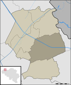
Pays de Montbéliard Agglomération is the communauté d'agglomération, an intercommunal structure, centred on the city of Montbéliard. It is located in the Doubs department, in the Bourgogne-Franche-Comté region, eastern France. It was established in January 2017 by the merger of the former communauté d'agglomération du Pays de Montbéliard with 3 former communautés de communes and 9 other communes. Its seat is in Montbéliard. Its population was 139,776 in 2017, of which 25,395 in Montbéliard proper.