Related Research Articles

Midway Atoll is a 2.4 sq mi (6.2 km2) atoll in the North Pacific Ocean. Midway Atoll is an insular area of the United States and is an unorganized and unincorporated territory. The largest island is Sand Island, which has housing and an airstrip. Immediately to the east of Sand Island across the narrow Brooks Channel is Eastern Island, which is uninhabited and no longer has any facilities. Forming a rough, incomplete circle around the two main islands and creating Midway Lagoon is Spit Island, a narrow reef.

Interstate H-3 (H-3) is an Interstate Highway located entirely within the US state of Hawaii on the island of Oʻahu. H-3 is also known as the John A. Burns Freeway, after the second governor of Hawaii. It crosses the Koʻolau Range along several viaducts and through the 5,165-foot-long (1,574 m) Tetsuo Harano Tunnels as well as the much smaller Hospital Rock Tunnels.

Kailua is a census-designated place (CDP) in Honolulu County, Hawaii, United States. It lies in the Koʻolaupoko District of the island of Oʻahu on the windward coast at Kailua Bay. It is in the judicial district and the ahupua'a named Ko'olaupoko. It is 12 miles (19 km) northeast of Honolulu – over Nu‘uanu Pali.
Kaneohe or Kāneʻohe is a census-designated place (CDP) included in the City and County of Honolulu and in Hawaiʻi state District of Koʻolaupoko on the island of Oʻahu. In the Hawaiian language, kāne ʻohe means "bamboo man". According to an ancient Hawaiian story, a local woman compared her husband's cruelty to the sharp edge of cutting bamboo; thus the place was named Kāneʻohe or "bamboo man".
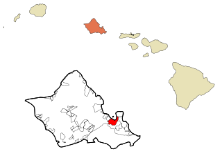
Marine Corps Base Hawaii (MCBH), formerly Marine Corps Air Station Kaneohe Bay and originally Naval Air Station Kaneohe Bay, is a U.S. Marine Corps facility and air station located on the Mokapu Peninsula of windward O'ahu in the City & County of Honolulu. Marine Corps Base Hawaii is home to Marines, Sailors, their family members, and civilian employees. The United States Marine Corps operates a 7,800-foot (2,400 m) runway at the base.
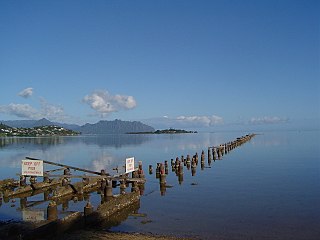
Kāneʻohe Bay, at 45 km2 (17 sq mi), is the largest sheltered body of water in the main Hawaiian Islands. This reef-dominated embayment constitutes a significant scenic and recreational feature along the northeast coast of the Island of Oʻahu. The largest population center on Kāneʻohe Bay is the town of Kāneʻohe.

The 5th Marine Division was a United States Marine Corps ground combat division which was activated on 11 November 1943 at Camp Pendleton, California during World War II. The 5th Division saw its first combat action during the Battle of Iwo Jima in 1945 where it sustained the highest number of casualties of the three Marine divisions of the V Amphibious Corps. The 5th Division was to be part of the planned invasion of the Japan homeland before Japan surrendered. Assault troops of the 5th Division were included in the Presidential Unit Citation awarded to the V Amphibious Corps for extraordinary heroism on Iwo Jima from 19 to 28 February 1945. The 5th Division was deactivated on 5 February 1946.

The 3d Marine Littoral Regiment is a regiment of the United States Marine Corps that is optimized for littoral maneuver in the Indo-Pacific Theater. Based at Marine Corps Base Hawaii, the regiment falls under the command of the 3rd Marine Division and the III Marine Expeditionary Force. It was known as the 3rd Marine Regiment from 1914 to 2022, when it was renamed as part of the Commandant of the Marine Corps' Force Design 2030 initiative. The 3d MLR has participated in the 2022 and 2023 Balikatan exercises in Northern Luzon, Philippines.

Marine Aircraft Group 32 (MAG-32) was a United States Marine Corps aviation unit established during World War II.

The U.S. Marine Corps Forces, Pacific (MARFORPAC) is the Marine Corps service component command of U.S. Indo-Pacific Command. It is the largest field command in the Marine Corps and is headquartered at Camp H. M. Smith in Hawaii. The MARFORPAC area of responsibility covers more than half of the earth's surface.
Naval Air Station Barbers Point, on O'ahu, home to John Rodgers Field, is a former United States Navy airfield closed in 1999, and renamed Kalaeloa Airport. Parts of the former air station serve as a film and television studio for the Hawaii State Film Office.

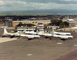
Marine Corps Air Station Kaneohe Bay or MCAS Kaneohe Bay is a United States Marine Corps (USMC) airfield located within the Marine Corps Base Hawaii complex, formerly known as Marine Corps Air Facility (MCAF) Kaneohe Bay or Naval Air Station (NAS) Kaneohe Bay. It is located two miles northeast of the central business district of Kaneohe, in Honolulu County, Hawaii, United States. The airfield has one runway (4/22) with a 7,771 x 200 ft asphalt surface.
The Fleet Marine Force, Pacific (FMFPAC) is the largest maritime landing force in the world. Its units are spread across the Pacific Ocean and reports to the United States Pacific Command. It is headquartered at MCB Camp H. M. Smith, HI and directs and commands all the subordinate elements of the Navy Expeditionary Strike Force and Marine Air-Ground Task Force components that follow under the 3rd, 5th, and 7th Fleet and the Marine Corps Forces, Pacific (MARFORPAC). The Commanding General of Marine Corps Forces, Pacific is dual-posted as the Commanding General of Fleet Marine Force, Pacific. FMFPAC is under operational control of the Commander, United States Pacific Fleet (COMPACFLT), when deployed.
The South Maui Coastal Heritage Corridor is a recreation and tourism project of the Tri-Isle Resource Conservation and Development Council. The non-profit council partners with the Natural Resources Conservation Service of the United States Department of Agriculture. The project is managed by a committee chairperson in cooperation with the Hawaii Department of Land and Natural Resources, Division of Forestry and Wildlife, Na Ala Hele Trails and Access Program, U.S. Fish and Wildlife Service, University of Hawaii, Sea Grant Extension Service, and individuals from the community of Kihei. The project protects and provides public access to South Maui's 15 mile leeward coastline.

Marine Corps Air Station Cherry Point or MCAS Cherry Point is a United States Marine Corps airfield located in Havelock, North Carolina, United States, in the eastern part of the state. It was built in 1941, and was commissioned in 1942 and is currently home to the 2nd Marine Aircraft Wing.
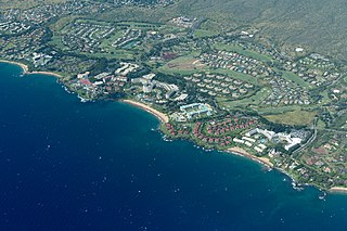
Wailea is a census-designated place (CDP) in Maui County, Hawaii, United States. As of the 2020 census, it had a population of 6,027. Prior to 2010, the area was part of the Wailea-Makena census-designated place. The community was developed in 1971 by a partnership of Alexander & Baldwin and Northwestern Mutual.

William Keolaloa Kahānui Sumner, Jr. was a high chief of the Kingdom of Hawaii through his mother's family; his father was an English captain from Northampton. Sumner married a Tahitian princess. Aided by royal family connections, he became a major landowner and politician in Hawaii.
The Hawaii Naval Militia is the inactive naval militia of Hawaii. As a naval militia, it was organized as a naval parallel to the Hawaii National Guard. Along with the National Guard, the Hawaii Naval Militia is recognized as part of the organized militia of Hawaii.

3rd Littoral Anti-Air Battalion is a United States Marine Corps aviation command and control and air defense unit that is optimized for operations in the first island chain. The battalion is based at Marine Corps Base Hawaii and falls under the command of the 3rd Marine Littoral Regiment and the 3rd Marine Division.

Ulupaʻu Crater is a tuff cone in the U.S. state of Hawaii, located near Marine Corps Base Hawaii on the Mokapu Peninsula.
References
| | This Hawaiʻi-related article is a stub. You can help Wikipedia by expanding it. |