Related Research Articles

The Napa River is a river approximately 55 miles (89 km) long in the U.S. state of California. It drains a famous wine-growing region called the Napa Valley, in the mountains north of the San Francisco Bay. Milliken Creek and Mt. Veeder watersheds are a few of its many tributaries. The river mouth is at Vallejo, where the intertidal zone of fresh and salt waters flow into the Carquinez Strait and the San Pablo Bay.
Steelhead, or occasionally steelhead trout, is the common name of the anadromous form of the coastal rainbow trout (Oncorhynchus mykiss irideus) or Columbia River redband trout. Steelhead are native to cold-water tributaries of the Pacific basin in Northeast Asia and North America. Like other sea-run (anadromous) trout and salmon, steelhead spawn in freshwater, smolts migrate to the ocean to forage for several years and adults return to their natal streams to spawn. Steelhead are iteroparous, although survival is approximately 10–20%.

The Chinook salmon is the largest and most valuable species of Pacific salmon. Its common name is derived from the Chinookan peoples. Other vernacular names for the species include king salmon, Quinnat salmon, Tsumen, spring salmon, chrome hog, Blackmouth, and Tyee salmon. The scientific species name is based on the Russian common name chavycha (чавыча).

The Cosumnes River is a river in northern California in the United States. It rises on the western slope of the Sierra Nevada and flows approximately 52.5 miles (84.5 km) into the Central Valley, emptying into the Mokelumne River in the Sacramento-San Joaquin Delta.

Lake Oroville is a reservoir formed by the Oroville Dam impounding the Feather River, located in Butte County, northern California. The lake is situated 5 miles (8 km) northeast of the city of Oroville, within the Lake Oroville State Recreation Area, in the western foothills of the Sierra Nevada. Known as the second-largest reservoir in California, Lake Oroville is treated as a keystone facility within the California State Water Project by storing water, providing flood control, recreation, freshwater releases to assist in controlling the salinity intrusion into the Sacramento-San Joaquin Delta and protecting fish and wildlife.

In 1942, the Coleman National Fish Hatchery was established under an act of the U.S. Congress to mitigate the loss of historic spawning habitat caused by the construction of dams. The fish hatchery is located in Shasta County, California, near the town of Anderson on the north bank of Battle Creek approximately 6 river miles (9.7 km) east of the Sacramento River. Coleman NFH covers approximately 75 acres (300,000 m2) of land owned by the U.S. Fish and Wildlife Service (USFWS), with an additional 63 acres (250,000 m2) of land in perpetual easements for pipelines and access. It is the largest salmon hatchery in the continental United States.

The Mokelumne River is a 95-mile (153 km)-long river in northern California in the United States. The river flows west from a rugged portion of the central Sierra Nevada into the Central Valley and ultimately the Sacramento–San Joaquin River Delta, where it empties into the San Joaquin River-Stockton Deepwater Shipping Channel. Together with its main tributary, the Cosumnes River, the Mokelumne drains 2,143 square miles (5,550 km2) in parts of five California counties. Measured to its farthest source at the head of the North Fork, the river stretches for 157 miles (253 km).

The Los Gatos Creek runs 24 miles (39 km) in California through Santa Clara Valley Water District's Guadalupe Watershed from the Santa Cruz Mountains northward through the Santa Clara Valley until its confluence with the Guadalupe River in downtown San Jose. The Guadalupe River then continues onward into San Francisco Bay.

The Nimbus Dam is a base load hydroelectric dam on the American River near Folsom, California. Approximately 8,700 acre-feet (10,700 dam3) of water is retained by the dam. It is responsible for the impoundment of water from the American River to create the Lake Natoma reservoir. The dam stands 87 feet and spans 1,093 feet. The Nimbus powerplant consists of two generators. Each generator produces enough electrical power to power over 200,000 100-watt light bulbs, about 15,500 kilowatts of electrical power. Nimbus Dam consists of 18 radial gates, each with their own gate bays. These 18 gates today are the ones that were completed in 1955 along with the rest of the dam. Of the eighteen gates, four of them have had their coating system replaced. This protects the gates from a faster rate of corrosion. The other fourteen gates have the original coating.
San Leandro Creek is a 21.7-mile-long (34.9 km) year-round natural stream in the hills above Oakland in Alameda County and Contra Costa County of the East Bay in northern California.

The Oroville–Thermalito Complex is a group of reservoirs, structures, and facilities located in and around the city of Oroville in Butte County, California. The complex serves not only as a regional water conveyance and storage system, but is the headwaters for, and therefore perhaps is the most vital part of, the California Department of Water Resources' State Water Project, as one of the largest publicly built and operated water and power development and conveyance systems.

Pardee Dam is a 345-foot (105 m)-high structure across the Mokelumne River which marks the boundary between Amador and Calaveras Counties, located in the foothills of the Sierra Nevada approximately 30 miles (48 km) northeast of Stockton.

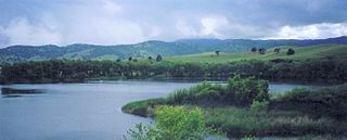
Camanche Reservoir is an artificial lake in the San Joaquin Valley in California in the United States, at the juncture of Amador, Calaveras, and San Joaquin counties. Its waters are impounded by Camanche Dam, which was completed in 1963. Camanche Reservoir is a source of water for industrial and municipal purposes and also provides flood control.

The American River is a 30-mile (50 km)-long river in California that runs from the Sierra Nevada mountain range to its confluence with the Sacramento River in downtown Sacramento. Via the Sacramento River, it is part of the San Francisco Bay watershed. This river is fed by the melting snowpack of the Sierra Nevada and its many headwaters and tributaries, including the North Fork American River, the Middle Fork American River, and the South Fork American River.

The Mokelumne Aqueduct is a 95-mile (153 km) water conveyance system in central California, United States. The aqueduct is supplied by the Mokelumne River and provides water to 35 municipalities in the East Bay in the San Francisco Bay Area. The aqueduct and the associated dams, pipelines, treatment plants and hydroelectric system are owned and operated by the East Bay Municipal Utility District (EBMUD) and provide over 90 percent of the water used by the agency.
Marsh Creek is a stream in east Contra Costa County, California in Northern California which rises on the eastern side of Mount Diablo and flows 30 miles (48 km) to the Sacramento–San Joaquin River Delta at Oakley, California, near Big Break Regional Shoreline. The creek flows through Marsh Creek State Park (California), where water is impounded to form Marsh Creek Reservoir, then through the city of Brentwood, California.
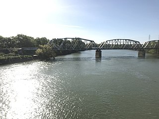
Camanche Dam is an earthfill Dam on the Mokelumne River in the central California, about 20 mi (32 km) from East Lodi. The dam and reservoir lie in the Sierra Nevada foothills in San Joaquin County. Construction of Camanche Dam was started in 1963 and completed in 1964. East Bay Municipal Utilities District (EBMUD) owns and operates it. The purpose of Camanche Dam and reservoir is to provide flood control, water flows for agriculture, habitat for fisheries and recreation for community.
The Nimbus Fish Hatchery is located in eastern Sacramento County, built on the downstream side of the Nimbus Dam. It is one of the 21 fish hatcheries the California Department of Fish and Wildlife oversees. Chinook salmon and steelhead are raised, and about 4 million Chinook salmon and 430,000 steelheads released each year.
The Hodge decision is a flow requirement that several water agencies must follow when they extract surface water from the American River. The flow requirements vary throughout the year, with the spring and summer months of March through June presenting the most restricted rate, at a minimum of 3,000 cubic feet per second (85 m3/s). The agencies must maintain these specified flow rates to divert water from the American River. If the American River's flow rate is less than the specified minimum rate, some water agencies must obtain water from other sources.
Lost Man Creek Dam was a gravity dam used by the Prairie Creek Fish Hatchery in Humboldt County, California from 1936 to 1955.
References
- Dan Bacher
- California Department of Fish and Game
- The Lodi News Sentinel