Molentargius - Saline Regional Park

Last updated
Designations
Official name Stagno di Molentargius
Designated 14 December 1976
Reference no. 133 [1]
View towards the Molentargius salt mills. Cagliaripoetto.jpg
View towards the Molentargius salt mills.

Molentargius - Saline Regional Park (Italian: Parco naturale regionale Molentargius - Saline) is a regional park in Sardinia, Italy. It was established in 1999 with the aim to protect and enhance a site of international interest, already included in the Ramsar Convention since 1977 because of its number relevance about stopover, wintering and nesting waterfowl bird species.

A regional park is an area of land preserved on account of its natural beauty, historic interest, recreational use or other reason, and under the administration of a form of local government.

Sardinia Island in the Mediterranean and region of Italy

Sardinia is the second-largest island in the Mediterranean Sea. It is located west of the Italian Peninsula and to the immediate south of the French island of Corsica.

Italy republic in Southern Europe

Italy, officially the Italian Republic, is a country in Southern Europe. Located in the middle of the Mediterranean Sea, Italy shares open land borders with France, Switzerland, Austria, Slovenia and the enclaved microstates San Marino and Vatican City, as well as a maritime border with Croatia. Italy covers an area of 301,340 km2 (116,350 sq mi) and has a largely temperate seasonal and Mediterranean climate. With around 61 million inhabitants, it is the fourth-most populous EU member state and the most populous country in Southern Europe.

Molentargius in Sardinian language means "donkeys handlers", as the salt extraction was the richest industry of the Cagliari area for millennia, the salt being transported by donkeys. The park is a wetland extending over an area of about 1600 hectares surrounded by the urbanized areas of Cagliari and the other towns of the metropolitan area, and the waterfront of Poetto beach.

Cagliari Comune in Sardinia, Italy

Cagliari is an Italian municipality and the capital of the island of Sardinia, an autonomous region of Italy. Cagliari's Sardinian name Casteddu literally means castle. It has about 155,000 inhabitants, while its metropolitan city has more than 431,000 inhabitants. According to Eurostat, the population of the Functional urban area, the commuting zone of Cagliari, rises to 476,974. Cagliari is the 26th largest city in Italy and the largest city on the island of Sardinia.

The uniqueness of this area is the presence of reservoirs of both freshwater and saltwater, separated by a plain characterized by prevailing aridity called Is Arenas ("The sands"). Areas with fresh water are the ponds of Bellarosa Minore and Perdalonga, born as expansion of rainwater tanks. Areas of salt water ponds include the production system of the former Statal Saline of Cagliari, consisting of the Bellarosa Maggiore or Is Molentargius (water storage tank evaporation), by the Pond of Quartu (second and third tanks evaporation), the other salting basins (saline of Cagliari).
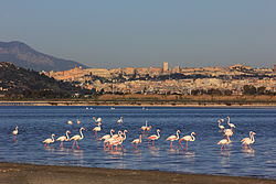
From 1850 to the present, 230 bird species, belonging to 53 families have been recorded in the Molentargius area.

Related Research Articles

Lake Natron salt lake

Lake Natron is a salt or soda lake in Arusha Region in Tanzania. It is in the Gregory Rift, which is the eastern branch of the East African Rift. The lake is within the Lake Natron Basin, a Ramsar Site wetland of international significance.

Lake Poopó salt lake

Lake Poopó is a large saline lake located in a shallow depression in the Altiplano Mountains in Oruro Department, Bolivia, at an altitude of approximately 3,700 m (12,100 ft). Because the lake was long and wide, it made up the eastern half of the department, known as a mining region in southwest Bolivia. The permanent part of the lake body covered approximately 1,000 square kilometres (390 sq mi) and it was the second-largest lake in the country. The lake received most of its water from the Desaguadero River, which flows from Lake Titicaca at the north end of the Altiplano. Since the lake lacked any major outlet and had a mean depth of less than 3 m (10 ft), the surface area differed greatly on a seasonal basis.

A Ramsar site is a wetland site designated to be of international importance under the Ramsar Convention.

Salt evaporation pond shallow artificial pond designed to extract salts from sea water or other brines

A salt evaporation pond is a shallow artificial salt pan designed to extract salts from sea water or other brines. Natural salt pans are geological formations that are also created by water evaporating and leaving behind salts. Some salt evaporation ponds are only slightly modified from their natural version, such as the ponds on Great Inagua in the Bahamas, or the ponds in Jasiira, a few kilometres south of Mogadishu, where seawater is trapped and left to evaporate in the sun.

Spittal Pond Nature Reserve

Spittal Pond Nature Reserve is the largest wildlife sanctuary in Bermuda, located close to the Atlantic coast of Smith's Parish. Surrounding the third largest pond in Bermuda, Spittal Pond, it covers an area of 60 acres (24 ha). It is one of 13 parks or reserves managed by the Bermuda Department of Conservation Services which protects and conserves environmentally critical areas and habitats. The pond reserve, a wetland site, is one of the seven Ramsar Sites in Bermuda, which was approved on 10 May 1999 for the criteria of its unique characteristics such as its lagoon which is permanently brackish, ecology featuring wet grassland and mangrove forests, seasonal shorebirds, other waterbirds and European eels.

Lake Tsimanampetsotsa lake in Madagascar

Lake Tsimanampetsotsa is a moderately alkaline lake in the Toliara Province, in the southwestern part of Madagascar. It is located at around 24°07′S43°45′E. The lake is an important wetland and is protected within a national park and as a Ramsar site. The Ramsar site has a total area of 456 km2 (176 sq mi), while the surface of the lake is much smaller. The lake Tsimanampetsotsa is a part of the Tsimanampetsotsa National Park.

Lake Burdur lake in Isparta Province, Turkey

Lake Burdur is a large saline lake of tectonic origin, positioned at the frontier between Burdur and Isparta provinces, in southwestern Turkey. It is located at around 37.75°N 30.18°E. It has an area of 250 km2 and maximum depth variously reported at between 50 and 110 m. Water level in the lake fluctuates. Lake Burdur is also an important wetland site for many bird species and is designated a Ramsar site.

Selargius Comune in Sardinia, Italy

Selargius, Ceràrgius or Ceràxius in Sardinian, is a comune (municipality) in the Metropolitan City of Cagliari in the Italian region Sardinia, located about 6 kilometres (4 mi) northeast of Cagliari. As of 2017, it has a population of 28,905.

Larnaca Salt Lake lake in Cyprus

Larnaca Salt Lake is a complex network of four salt lakes of different sizes to the west of the city of Larnaca. The largest is lake Aliki, followed by lake Orphani, lake Soros and lake Spiro. They form the second largest salt lake in Cyprus after the Limassol Salt Lake. The total surface area of the lakes adds up to 2.2 km2 and being just off the road leading to Larnaca International Airport is one of the most distinctive landmarks of the area. It is considered one of the most important wetlands of Cyprus and it has been declared a Ramsar site, Natura 2000 site, Special Protected Area under the Barcelona Convention and an Important Bird Area (IBA). It is surrounded by halophytic scrubland and on its bank lies the Hala Sultan Tekke, one of the holiest of shrines within Ottoman Islam. It houses the tomb of Umm Haram, Muhammad's 'wet-nurse'.

Stagno di Cagliari

The Stagno di Santa Gilla, or Stagno di Cagliari, is a coastal lagoon at the mouths of the rivers Cixerri and Mannu near Cagliari, on the Golfo degli Angeli in southern Sardinia, Italy. It has been designated as a wetland site of international importance under the Ramsar Convention since 1976 and is ranked among the most important of such areas in the European Union.

Piccaninnie Ponds Conservation Park Protected area near Mount Gambier in South Australia

Piccaninnie Ponds Conservation Park, formerly the Piccaninnie Ponds National Park, is a protected area of 862 hectares located in southeastern South Australia near Mount Gambier.

Sabkhat al-Jabbul lake in Syria

Sabkhat al-Jabbūl or Mamlahat al-Jabbūl or Lake Jabbūl is a large, traditionally seasonal, saline lake and concurrent salt flats 30 km southeast of Aleppo, Syria, in the Bāb District of Aleppo Governorate. It is the largest natural lake in Syria and the second largest lake after the artificial Lake Assad. In 2009 the lake covered about 100 km2 (39 sq mi) and was relatively stable. The salt flats are extensive and can be seen from space. The area includes the Sabkhat al-Jabbul Nature Reserve, a protected waterfowl site.

Reedy Lake lake in Victoria, Australia

Reedy Lake, historically also known as Lake Reedy, is a shallow 5.5-square-kilometre (2.1 sq mi) intermittent freshwater lake or swamp on the lower reaches of the Barwon River, on the Bellarine Peninsula southeast of Geelong in the Australian state of Victoria.

Edithvale-Seaford Wetlands nature reserve in Australia

The Edithvale-Seaford Wetlands are a group of two principally freshwater swamps, totalling 261 hectares, lying in the suburbs of Aspendale, Edithvale, Chelsea Heights, and Seaford in south-eastern Melbourne, Victoria, Australia. Together they form the Edithvale-Seaford Wetlands Ramsar Site. With the nearby Eastern Treatment Plant, they form the Carrum Wetlands Important Bird Area.

Toolibin Lake lake in Australia

Toolibin Lake is a seasonal fresh to brackish water perched lake or wooded swamp, in south-western Australia. The lake is contained with a 493-hectare (1,218-acre) nature reserve and it is located about 200 kilometres (124 mi) south-east of Perth, in the Shire of Narrogin, and 40 kilometres (25 mi) east of the town of Narrogin, in the Wheatbelt region of Western Australia. The lake is listed by the Australian Government as a threatened ecological community under the Environment Protection and Biodiversity Conservation Act 1999.

Sečovlje Saltworks

The Sečovlje Saltworks is the largest Slovenian salt evaporation pond. Along with the Strunjan Saltworks, they are the northernmost Mediterranean saltworks and one of the few where salt is still produced in a traditional way, as well as a wetland of international importance and a breeding place for waterbirds. They are part of the Piran Saltworks and are located at Parecag in Slovenian Istria, the southwest of the country, at the Adriatic Sea, along the mouth of the Dragonja River near Sečovlje.

Valli di Comacchio lagoons in Emilia-Romagna, Italy

The Valli di Comacchio, meaning "fish basins of Comacchio", are a series of contiguous brackish lagoons situated to the south of Comacchio, close to the Adriatic coast of the Emilia-Romagna region in northern Italy. They lie within the comuni of Comacchio and Argenta in the province of Ferrara and the comune of Ravenna in the province of Ravenna.

North Victorian Wetlands

The North Victorian Wetlands, also known as the Kerang Wetlands, comprise an extensive series of over 100 freshwater, brackish and saline lakes and swamps on the floodplain of the Loddon River where it enters the Murray valley, in the vicinity of the town of Kerang, in northern Victoria, south-eastern Australia. They are important for a variety, and sometimes large numbera, of waterbirds.

Tropical salt pond ecosystem A buffer zone between terrestrial and marine ecosystems

Salt ponds are a natural feature of both temperate and tropical coastlines. These ponds form a vital buffer zone between terrestrial and marine ecosystems. Contaminants such as sediment, nitrates and phosphates are filtered out by salt ponds before they can reach the ocean. The depth, salinity and overall chemistry of these dynamic salt ponds fluctuate depending on temperature, rainfall, and anthropogenic influences such as nutrient runoff. The flora and fauna of tropical salt ponds differ markedly from those of temperate ponds. Mangrove trees are the dominant vegetation of tropical salt pond ecosystems, which also serve as vital feeding and breeding grounds for shore birds.

Sawa Lake lake in Irag

Sawa Lake is an Endorheic basin located in the Iraqi governorate of Muthanna near to the Euphrates River, some 23 kilometres (14 mi) to the west of Al-Samawa city. This lake has no inlet or outlet, but it draws water from the Euphrates through a system of joint cracks and fissures which transport water to aquifers beneath it. The water's level fluctuates during dry and wet seasons but does not dry up because of the equilibrium state between water feed and evaporation.

References

  1. "Stagno di Molentargius". Ramsar Sites Information Service. Retrieved 25 April 2018.