Mollalar | |
|---|---|
 Mollalar | |
| Coordinates: 40°04′07.7″N46°49′31.2″E / 40.068806°N 46.825333°E | |
| Country | |
| District | Agdam |
| Population (2015) [1] | |
| • Total | 281 |
| Time zone | UTC+4 (AZT) |
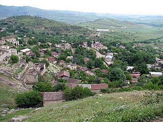
Mollalar is a village in the Agdam District of Azerbaijan.
Mollalar | |
|---|---|
| Mollalar | |
| Coordinates: 40°04′07.7″N46°49′31.2″E / 40.068806°N 46.825333°E | |
| Country | |
| District | Agdam |
| Population (2015) [1] | |
| • Total | 281 |
| Time zone | UTC+4 (AZT) |
Mollalar is a village in the Agdam District of Azerbaijan.
The village was located in the Armenian-occupied territories surrounding Nagorno-Karabakh, coming under the control of ethnic Armenian forces during the First Nagorno-Karabakh War in the early 1990s. The village subsequently became part of the breakaway Republic of Artsakh as part of its Martakert Province, where it was known as Nor Aygestan (Armenian : Նոր Այգեստան). It was returned to Azerbaijan as part of the 2020 Nagorno-Karabakh ceasefire agreement.
Historical heritage sites in and around the village include tombs from the 2nd–1st millennia BCE. [1]

Nagorno-Karabakh is a region in Azerbaijan, covering the southeastern stretch of the Lesser Caucasus mountain range. Part of the greater region of Karabakh, it spans the area between Lower Karabakh and Syunik. Its terrain mostly consists of mountains and forestland.

Artsakh, officially the Republic of Artsakh or the Republic of Nagorno-Karabakh, was a breakaway state in the South Caucasus whose territory was internationally recognised as part of Azerbaijan. Between 1991 and 2023, Artsakh controlled parts of the former Nagorno-Karabakh Autonomous Oblast of the Azerbaijani Soviet Socialist Republic, including its capital Stepanakert. It had been an enclave within Azerbaijan from the 2020 Nagorno-Karabakh war until the 2023 Azerbaijani offensive, when the Azerbaijani military took control over the remaining territory controlled by Artsakh. Its only overland access route to Armenia after the 2020 war was via the five kilometres (3.1 mi)–wide Lachin corridor, which was placed under the supervision of Russian peacekeeping forces.

Shahumyan Province was a province of the breakaway Republic of Artsakh, de jure part of the Republic of Azerbaijan. The capital of the province was Karvachar. Shahumyan Province had 17 communities of which one is considered urban and 16 are rural. Its bordered Martakert Province to the east, Kashatagh Province to the south, Gegharkunik and Vayots Dzor provinces of Armenia to the west and Dashkasan, Goygol and Goranboy districts of Azerbaijan to the north.

Vaghuhas or Gozlu is a village located in the Kalbajar District of Azerbaijan, in the region of Nagorno-Karabakh. Until 2023 it was controlled by the breakaway Republic of Artsakh. The village had an ethnic Armenian-majority population until the exodus of the Armenian population of Nagorno-Karabakh following the 2023 Azerbaijani offensive in Nagorno-Karabakh.
Poghosagomer or Devedashy is a village located in the Kalbajar District of Azerbaijan, in the region of Nagorno-Karabakh. Until 2023 it was controlled by the breakaway Republic of Artsakh. The village had an ethnic Armenian-majority population until the exodus of the Armenian population of Nagorno-Karabakh following the 2023 Azerbaijani offensive in Nagorno-Karabakh.
Suarasy is a village in the Lachin District of Azerbaijan.
Fətəlipəyə is a village in the Lachin District of Azerbaijan.
Sus is a village in Lachin District of Azerbaijan. It was formerly under the supervision of the Russian peacekeeping force following the ceasefire agreement that ended the 2020 Nagorno-Karabakh war. The village came under the de facto control of the breakaway Republic of Artsakh from 1992–2022, is administrated as part of its Kashatagh Province, and is de jure part of the Lachin District of Azerbaijan. As of 26 August 2022, Azerbaijan regained control of villages in the Lachin corridor, including Lachin, Sus, and Zabukh.
Kichan is a village located in the Agdam District of Azerbaijan, in the disputed region of Nagorno-Karabakh. The village had an ethnic Armenian-majority population until the exodus of the Armenian population of Nagorno-Karabakh following the 2023 Azerbaijani offensive in Nagorno-Karabakh.
Varnkatagh or Lulasaz is a village located in the Tartar District of Azerbaijan, in the region of Nagorno-Karabakh. Until 2023 it was controlled by the breakaway Republic of Artsakh. The village had an ethnic Armenian-majority population until the exodus of the Armenian population of Nagorno-Karabakh following the 2023 Azerbaijani offensive in Nagorno-Karabakh.
Chayly or Aygestan is a village in the Tartar District of Azerbaijan, in the disputed region of Nagorno-Karabakh. Prior to 2023, the village was on the ceasefire line between the armed forces of the breakaway state Republic of Artsakh and those of Azerbaijan.

Talish is a village in the Aghdara District in Azerbaijan, in the disputed region of Nagorno-Karabakh. The village had an ethnic Armenian-majority population prior to the 2020 Nagorno-Karabakh war, and also had an Armenian majority in 1989.
Sor or Tsor is a village in the Khojavend District of Azerbaijan, in the disputed region of Nagorno-Karabakh. The village had an ethnic Armenian-majority population prior to the 2020 Nagorno-Karabakh war, and also had an Armenian majority in 1989.
Spitakashen is a village in the Khojavend District of Azerbaijan. The village had an ethnic Armenian-majority population prior to the 2020 Nagorno-Karabakh war, and also had an Armenian majority in 1989.
Edilli or Ukhtadzor is a village in the Khojavend District of Azerbaijan, in the disputed region of Nagorno-Karabakh. The village had an ethnic Armenian-majority population prior to the 2020 Nagorno-Karabakh war, and also had an Armenian majority in 1989.
Akhullu or Hartashen is a village in the Khojavend District of Azerbaijan, in the disputed region of Nagorno-Karabakh. The village had an Azerbaijani-majority population prior to their expulsion during the First Nagorno-Karabakh War.

Dudukchu or Kyuratagh is a village in the Khojavend District of Azerbaijan, in the disputed region of Nagorno-Karabakh. The village had an ethnic Armenian-majority population prior to the 2020 Nagorno-Karabakh war, and also had an Armenian majority in 1989.
Tugh or Togh is a village in the Khojavend District of Azerbaijan, in the region of Nagorno-Karabakh. The village had a mixed Armenian-Azerbaijani population before the First Nagorno-Karabakh War, the Azerbaijani inhabitants fled the fighting in 1991, and the Armenian population fled the village during the 2020 Nagorno-Karabakh war.
Mollalar is a village in the Lachin District of Azerbaijan. Close by is the ghost town of Kizilja.
Petrosashen is a village in the Khojavend District of Azerbaijan, in the disputed region of Nagorno-Karabakh.
Capital: Martakert | ||
| Urban communities |  | |
| Rural communities |
| |
| Not under Artsakh control | ||
| | This Aghdam District location article is a stub. You can help Wikipedia by expanding it. |
