
The Geography of Kenya is diverse, varying amongst its 47 counties. Kenya has a coastline on the Indian Ocean, which contains swamps of East African mangroves. Inland are broad plains and numerous hills. Kenya borders South Sudan to the northwest, Uganda to the west, Somalia to the east, Tanzania to the south, and Ethiopia to the north. Kenya currently faces border disputes with South Sudan over the Ilemi Triangle and with Somalia over Jubbaland where, if the Somalian Government gives it up, it could be a new part of Kenya, which would bring the total land area of Kenya to approximately 692,939 km2.

Mombasa is a coastal city in southeastern Kenya along the Indian Ocean. It was the first capital of British East Africa, before Nairobi was elevated to capital status in 1907. It now serves as the capital of Mombasa County. The town is known as "the white and blue city" in Kenya. It is the country's oldest and second-largest city after Nairobi, with a population of about 1,208,333 people according to the 2019 census.
Mombasa Island is a 5 by 3 km coral outcrop located on Kenya's coast on the Indian Ocean, which is connected to the mainland by a causeway. Part of the city of Mombasa is located on the island, including the Old Town.

Kiên Giang is a province of Vietnam, located in the Mekong Delta region of southern Vietnam. It is known for fishing and rice farming. The provincial capital is Rạch Giá, 155 mi (249 km) from Ho Chi Minh City. Kiên Giang's area is 6,352.02 km2 (2,452.53 sq mi) and its population is about 1,723,067 (2019), of which 22 percent live in urban areas.

Mombasa County is one of the 47 counties of Kenya and has its capital in Mombasa City. In terms of economy it is second most developed after Nairobi city. Initially Mombasa was one of the districts of Kenya until 2013 when it was reconstituted as a county, on the same boundaries. It is the smallest county in Kenya, covering an area of 229.7 km2 excluding 65 km2 of water mass. The county is situated in the south eastern part of the former Coast Province, bordering Kilifi County to the north, Kwale County to the south west and the Indian Ocean to the east. Administratively, the county is divided into seven divisions, eighteen locations and thirty sub-locations.
Embu County is a county in the Republic of Kenya. The capital of Embu County and former Eastern province headquarters, Embu town, is a largely metropolitan area with a population of 608,599 persons. The county borders Kirinyaga to the west, Kitui to the east, Tharaka Nithi to the north and Machakos to the south. The county occupies an area of 2,821 km2. The county is home to the Aembu and Mbeere
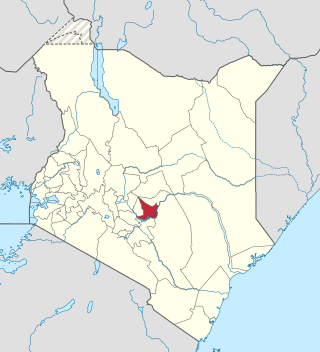
Marsabit County is a county in Kenya, covering a surface area of 66,923.1 square kilometres. Marsabit is the second largest county by size in Kenya after Turkana county which has an area of 71,597.8 km2. Its capital is Marsabit and its largest town is Moyale. According to the 2019 census, the county had a population of 459,785. It is bordered to the North by Ethiopia, to the West by Turkana County to the South by Samburu County and Isiolo County, and to the East by Wajir County.

Swahili architecture is a term used to designate a whole range of diverse building traditions practiced or once practiced along the eastern and southeastern coasts of Africa. Rather than simple derivatives of Islamic architecture from the Arabic world, Swahili stone architecture is a distinct local product as a result of evolving social and religious traditions, environmental changes, and urban development.

Taita–Taveta County is a county in Kenya, located approximately 200 km northwest of Mombasa, and 360 km southeast of Nairobi, it has a port and major gateway to the United Republic of Tanzania through Taveta. The county headquarters are located in Mwatate. It is one of the six counties in the Coastal region of Kenya. Major towns include Voi, Taveta, Mwatate, and Wundanyi.

Kirinyaga County is a county in the former Central Province of Kenya, located south of Mount Kenya. Its capital is Kutus and its largest town is Wanguru. In 2019, the county had a population of 610,411 people and has an area of 1,478.1 km2. The county is bordered to the east and south by Embu County, to the south by a tiny part of Machakos County, to the southwest by Murang'a County and to the northwest by Nyeri County.

The districts of Kenya were divided into 262 divisions (matarafa). Divisions of Kenya were further subdivided into locations. Today's counties of Kenya are based on the merging of some of the districts on this list and since the divisions are one level under the districts they are now the sub-counties. This is because Kenya recently changed its constitution and 47 Counties emerged. Here are the divisions listed below, by district :
Changamwe is a suburb of Mombasa, in Mombasa County, in the former Coast Province of Kenya.
Changamwe Constituency is an electoral constituency in Mombasa County, Kenya. It used to be one of the four constituencies in Mombasa district. With the promulgation of the new constitution in August 2010, it saw the creation of two more constituencies in Mombasa County. These were Jomvu and Nyali Constituencies which were curved out from Changamwe and Kisauni Constituencies, respectively. This made a total of six constituencies in 2012.
Bamburi Airport is an airport in Kenya.
Mackinnon Road Airport is an airport in Mackinnon Road, Kenya.
Sub-counties, formerly known as Districts, are the decentralised units through which government of Kenya provides functions and services. At national level, sub-counties take a more administrative function like security, statistical purposes, provision of government services, etc. Even though the sub-counties are divisions of counties, powers to create new national sub-counties lies with the national government. As of 2023, there are 314 sub-counties, compared to 290 constituencies. A deputy county commissioner is appointed by the state to lead each sub-county. The sub-counties are further divided into divisions, locations and sub-locations.
Taita-Taveta District was a district of Kenya, located in the Coast Province of the country. It lies approximately 200 km northwest of Mombasa city and 360 km southeast of Nairobi city.
Mombasa Mainland Desalination Plant (MMDP), is a planned water purification project in Kenya.
Mombasa Island South was an electoral constituency in Mombasa District of Coast Province. Created for the 1963 general elections, it is one of the three original constituencies of Mombasa District and among the 117 constituencies of independent Kenya. It was renamed Mombasa West Constituency for 1966 election. The constituency was abolished in 1988, and consolidated with Mombasa Central to form Mvita constituencies.
Mombasa Mainland was an electoral constituency in Mombasa District of Coast Province. Created for the 1963 general elections, it is one of the three original constituencies of Mombasa District and among the 117 constituencies of independent Kenya. The constituency was abolished in 1988, and split into Kisauni, Changamwe & Likoni constituencies.
