Related Research Articles
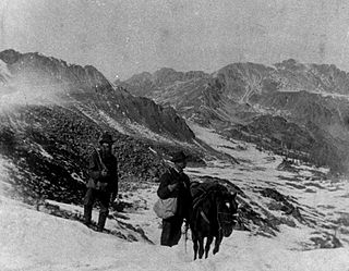
The Pike's Peak gold rush was the boom in gold prospecting and mining in the Pike's Peak Country of western Kansas Territory and southwestern Nebraska Territory of the United States that began in July 1858 and lasted until roughly the creation of the Colorado Territory on February 28, 1861. An estimated 100,000 gold seekers took part in one of the greatest gold rushes in North American history.

The Monte Cristo Gold Mine is a gold mine in the San Gabriel Mountains near Los Angeles, California, USA.

Cherryville is an unincorporated community in the foothills of the Monashee Mountains in British Columbia with a population of approximately 930. It is located 22 kilometres (14 mi) east of Lumby, along Highway 6.
Kingfisher Creek Provincial Park is a provincial park in British Columbia, Canada located 15 km southeast of Sicamous and west of Mabel Lake in the Monashee Mountains. The park is 440 hectares and was created to enhance the viability of the Kingfisher Creek Ecological Preserve.

Monashee Provincial Park is a provincial park located just outside of Cherryville, British Columbia, Canada. It is located in the central Monashee Mountains between the Arrow Lakes and the upper Shuswap River drainage, just east of Sugar Lake. It is a remote grizzly habitat that is a walk-in only. Mount Fosthall is the highest peak in the area and can be hiked in a day. In addition to hiking and alpinism other activities include fishing.
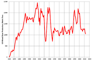
Silver mining in the United States began on a major scale with the discovery of the Comstock Lode in Nevada in 1858. The industry suffered greatly from the demonetization of silver in 1873 by the Coinage Act of 1873, known pejoratively as the "Crime of 73", but silver mining continues today.
Gold mining in Colorado, a state of the United States, has been an industry since 1858. It also played a key role in the establishment of the state of Colorado.
Silver mining in Colorado has taken place since the 1860s. In the past, Colorado called itself the Silver State.
Silver mining in Nevada, a state of the United States, began in 1858 with the discovery of the Comstock Lode, the first major silver-mining district in the United States. Nevada calls itself the "Silver State." Nevada is the nation's second-largest producer of silver, after Alaska. In 2014 Nevada produced 10.93 million troy ounces of silver, of which 6.74 million ounces were as a byproduct of the mining of gold. The largest byproducers were the Hycroft Mine, the Phoenix Mine, the Midas Mine and Round Mountain.
Gold mining in Alaska, a state of the United States, has been a major industry and impetus for exploration and settlement since a few years after the United States acquired the territory in 1867 from the Russian Empire. Russian explorers discovered placer gold in the Kenai River in 1848, but no gold was produced. Gold mining started in 1870 from placers southeast of Juneau, Alaska.
The Gold Range is a subrange of the Monashee Mountains in the southern British Columbia Interior. This range originally applied to all of the Monashees between the Arrow Lakes and the Okanagan but today only applies to a narrow stretch of the Monashee Mountains' eastern flank adjoining Upper Arrow Lake, west of the upper Shuswap River.

The Kettle River Range, often called the Kettle Range, is the southernmost range of the Monashee Mountains, located in far southeastern British Columbia, Canada and Ferry County, Washington, in the United States. Most of the northern half of the range is protected by the Colville National Forest and the southern half of the range is located on the Colville Indian Reservation. The highest peak is Copper Butte, which reaches 2,177 metres (7,142 ft). The range is crossed by Washington State Route 20 at Sherman Pass.
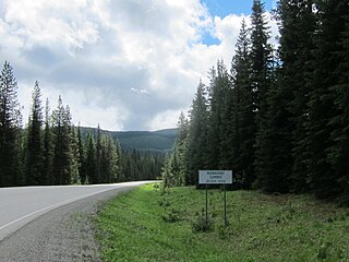
Monashee Pass, 1,189 m (3,901 ft), is a mountain pass in the Monashee Mountains of the Southern Interior of British Columbia, Canada. Located southeast of Cherryville, the pass is used by British Columbia Highway 6 connecting Vernon to Nakusp on Arrow Lake, and beyond to the cities of the West Kootenay. It is the "prominence col" for Big White Mountain, which is the highest mountain to its southwest.

Castle Dome Landing, Arizona is a ghost town in the Castle Dome Mountains of Yuma County in the U.S. state of Arizona. It was first settled as a transport depot and mining camp around 1863 in what was then the Arizona Territory.
The Sawtooth Range is a subrange of the Shuswap Highland area of the central Monashee Mountains in the Southern Interior of British Columbia, Canada. It is located between Mabel Lake (W) and Sugar Lake (E) and bounded on the south by the upper Shuswap River. Its northern boundary is just south of the Three Valley Gap area of Eagle Pass, which is the route of the Canadian Pacific Railway mainline and the Trans-Canada Highway. To the east, across the uppermost Shuswap River above Sugar Lake, is the Gold Range of the main spine of the Monashees, to which it is connected by the col of Joss Pass. To the west, it is adjoined by the rest of the Shuswap Highland, of which it is a part and is an intermediary mountainous plateau between the Monashees and the northeastern Thompson Plateau.
Joss Pass, 1345 m (4413 ft), is a mountain pass in the central Monashee Mountains of the Southern Interior of British Columbia, Canada. Located just south of the Three Valley Gap area of Eagle Pass, which is the route of the Trans-Canada Highway and the mainline of the Canadian Pacific Railway. It forms the divide between the headwaters of the Shuswap River and those of its eventual tributary Wap Creek, which joins the Shuswap via Mabel Lake. It forms the prominence col for Tsuius Mountain, the highest mountain of the Sawtooth Range, which is part of the Shuswap Highland. It is located just east of Joss Mountain, which is the northernmost peak of the Sawtooths.
McDame Creek is a creek in Cassiar Land District of British Columbia, Canada. The creek flows southeast into Dease River and is south of Good Hope Lake. The creek was discovered in 1874 by a prospector, named Harry McDame. McDame Creek was mined for gold in the 19th century. A camp, called Centreville, contained cabins and stores and served as a trading centre for miners working on McDame Creek in the 19th century. In 1877, a 72-ounce (2.04-kg) solid gold nugget, valued at $1,300, was found in McDame Creek. The solid gold nugget was found by a prospector named Al Freeman, it was the largest found in the province. This nugget was found roughly where 1st N. Fork Creek flows into McDame Creek.
Cherry Creek is a creek located in the Okanagan region of British Columbia. The south fork of Cherry Creek is known as Monashee Creek. Cherry Creek was discovered in the 1800s and mined for gold. The Creek was mined in the 1800s by Christien, Schneider, Bissett, and Leblanc. Chinese and European miners worked Cherry Creek. The largest gold nugget found in Cherry Creek weighed 8 to 9 ounces with a value of $130.
Gold Creek is a creek in Stevens County, Washington. Gold Creek flows into Sheep Creek, a tributary of the Columbia. The Gold Creek Basin is located around Gold Creek.
The Perry River, sometimes referred to as the North Fork of the Eagle River, is a mountain river in the interior of British Columbia, Canada. It flows out of the Monashee Mountains and joins the Eagle River near the town of Malakwa. It is part of the Thompson River system, which drains into the Fraser River. The river's watershed area is 43,646 hectares (169 sq mi), and major tributaries to the river include Bews and Rocky creeks.
References
- ↑ "Monashee Creek". BC Geographical Names .
- ↑ N.L. Barlee (1973), Gold Creeks and Ghost Towns. Canada West Publications.
50°14′N118°33′W / 50.233°N 118.550°W
| | This article related to a river in British Columbia, Canada is a stub. You can help Wikipedia by expanding it. |