
Polyarny is a town and the administrative center of the closed administrative-territorial formation of Alexandrovsk in Murmansk Oblast, Russia, situated on the outermost western side of the Kola Bay. Population: 17,293 (2010 Census); 18,552 (2002 Census); 27,635 (1989 Census).

Apatity is a town in Murmansk Oblast, Russia, located along the Murman Railway between Lake Imandra and the Khibiny Mountains, 23 km (14 mi) west of Kirovsk and 185 km (115 mi) south of Murmansk, the administrative center of the oblast. The town is named after one of its most abundant natural resources in the area, apatite, the raw mineral used in the production of phosphorus mineral fertilizers. Population: 59,672 (2010 Census).
Murmansk Oblast is a federal subject of Russia, which is located in the northwestern part of the country, occupying mostly the Kola Peninsula. The oblast itself was established on May 28, 1938, but some kind of administrative organization of the territory existed here since at least the 13th century. As of the 2002 Census, Russians account for the majority of the oblast's population, with the indigenous Sami constituting only a 0.20% minority (1,769 people).

Olenegorsk is a town in Murmansk Oblast, Russia, located north of the Arctic Circle, 112 kilometers (70 mi) south of Murmansk. Population: 23,072 (2010 Census); 25,166 ; 35,584 (1989 Census).
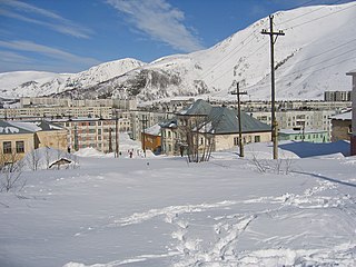
Kirovsk, known as Khibinogorsk (Хибиного́рск) until 1934, is a town in Murmansk Oblast, Russia, located at the spurs of the Khibiny Mountains on the shores of the Lake Bolshoy Vudyavr, 175 kilometers (109 mi) south of Murmansk. Population: 28,625 (2010 Census).
Kola is a town and the administrative center of Kolsky District of Murmansk Oblast, Russia, located at the confluence of the Kola and Tuloma Rivers, 12 kilometers (7.5 mi) south of Murmansk and 24 kilometers (15 mi) southwest of Severomorsk. It is the oldest town of the Kola Peninsula. Population: 10,437 (2010 Census); 11,060 ; 16,541 (1989 Census).

Lovozersky District is an administrative district (raion), one of the six in Murmansk Oblast, Russia. Municipally, it is incorporated as Lovozersky Municipal District. It occupies most of the central and northeastern parts of the Kola Peninsula. The area of the district is 53,800 square kilometers (20,800 sq mi). Its administrative center is the rural locality of Lovozero. District's population: 11,820 (2010 Census); 14,311 (2002 Census); 18,263 (1989 Census). The population of Lovozero accounts for 24.3% of the district's total population.

Zasheyek is a rural locality in administrative jurisdiction of Polyarnye Zori Town with Jurisdictional Territory in Murmansk Oblast, Russia, located beyond the Arctic Circle on the Kola Peninsula at a height of 142 meters (466 ft) above sea level. Population: 901.
Drozdovka was a rural locality in administrative jurisdiction of the closed administrative-territorial formation of Ostrovnoy in Murmansk Oblast, Russia, located on the Kola Peninsula beyond the Arctic Circle at the elevation of 1 meter above sea level.
Sayda-Guba, also known in English as Sayda Bay, is a rural locality within the administrative jurisdiction of the closed administrative-territorial formation of Alexandrovsk in Murmansk Oblast, Russia, located beyond the Arctic Circle at a height of 10 meters (33 ft) above sea level. As of the 2010 Census, it had no recorded population.

Kolsky District is an administrative district (raion), one of the six in Murmansk Oblast, Russia. As a municipal division, it is incorporated as Kolsky Municipal District. It is located in the northwest of the oblast, partially lies on the Kola Peninsula, and borders with the Barents Sea in the north and Finland in the west. The area of the district is 27,600 square kilometers (10,700 sq mi). Its administrative center is the town of Kola. Population: 44,670 (2010 Census); 51,125 (2002 Census); 73,555 (1989 Census). The population of Kola accounts for 23.4% of the district's total population.

Tersky District is an administrative district (raion), one of the six in Murmansk Oblast, Russia. Municipally, it is incorporated as Tersky Municipal District. It is located in the south of the Kola Peninsula and borders the White Sea in the south. The area of the district is 19,300 square kilometers (7,500 sq mi). Its administrative center is the urban locality of Umba. District's population: 6,288 (2010 Census); 7,434 (2002 Census); 9,752 (1989 Census). The population of Umba accounts for 88.0% of the district's total population.
Murmansk Governorate was an administrative division of the early Russian SFSR which existed in 1921–1927. The governorate was established on the territory of former Alexandrovsky Uyezd of Arkhangelsk Governorate by the All-Russian Central Executive Committee (VTsIK) Decree issued on June 13, 1921. The administrative center was in Murmansk.
Kirovsky District was an administrative division of Murmansk Okrug of Leningrad Oblast, and later a district of Murmansk Oblast, of the Russian SFSR, Soviet Union, which existed in 1935–1954.
Polyarny District was an administrative division of Murmansk Okrug of Leningrad Oblast of the Russian SFSR, Soviet Union, and later of Murmansk Oblast, which existed in 1927–1960.
Teribersky District, also known as Severomorsky District was an administrative division of Murmansk Okrug of Leningrad Oblast of the Russian SFSR, Soviet Union, and later of Murmansk Oblast, which existed in 1927–1963.
Saamsky District was an administrative division of Murmansk Okrug of Leningrad Oblast, and later of Murmansk Oblast, of the Russian SFSR, Soviet Union, which existed in 1927–1963.

Kandalakshsky District is an administrative district, one of the six in Murmansk Oblast, Russia. As a municipal division, it is incorporated as Kandalakshsky Municipal District. It is located in the southwest of the oblast, and borders with Kovdorsky District to the north, Loukhsky District of the Republic of Karelia, and with Finland to the west. The area of the district is 14,400 square kilometers (5,600 sq mi). Its administrative center is the town of Kandalaksha. Population: 49,544 (2010 Census); 60,140 (2002 Census); 78,239 (1989 Census). The population of Kandalaksha accounts for 72.0% of the district's total population.


