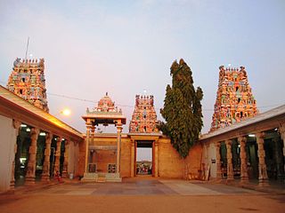
Tiruchengode is a selection-grade municipality located in western part of southern Indian state of Tamil Nadu. It is famous for the ancient hilltop Ardhanareeswarar Temple, dedicated to the unique combined male-female form of Lord Shiva and Goddess Parvathi. This important place of pilgrimage is mentioned in the Tamil work Silapathikaram as 'Nedulkundru' and is celebrated in the hymns of Saivite saints. The equally famous Chenkottu Velavar Temple, dedicated to Lord Murugan, is situated on the same hill. As of 2011, the town had a population of 95,335. As per 2011 population, Tiruchengode is the largest city in Namakkal district. It is also famous for rig business.
Avalpoondurai is a panchayat town in Erode district in the state of Tamil Nadu, India. It is situated 14 kilometres from Erode and an important junction on SH-83A en route to Dharapuram and other important small towns like Modakuruchi and Elumathur. It is about 415 km from Chennai, 100 km from Palani, 100 km from Coimbatore, 50 km from Tiruppur and from Gobicheittipalayam.
Chennimalai is a town in Erode district, Tamil Nadu, India. It is situated away from Erode of about 28kms., Chenni which means Chief and Malai means Hill. It is popularly known as the 'Handloom Town'.

Dharapuram is a town situated along the banks of Amaravati River in Tiruppur district in the Indian state of Tamil Nadu. Dharapuram is one of the oldest towns in South India and was the capital of Kongu Nadu under the Cheras, Western Ganga Dynasty and later Kongu Cholas, at which time it was known as Viradapuram. Amaravathi River flows through the town. As of 2011, the town had a population of 67,007. The city houses famous temples including Agatheeswarar Temple, Kaadu Hanumanthasamy temple and many other old temples.
Kalappanaickenpatti is a panchayat town in Senthamangalam Taluk, Namakkal district in the Indian state of Tamil Nadu
Kanjikoil is a panchayat town in Erode district in the Indian state of Tamil Nadu. The ancient name of the town is "Kanji Kooval" and it is called by the Name Kanji koil or Kanji Kovil.
Kodumudi is a panchayat town and taluk headquarters of Kodumudi taluk in Erode district at state of Tamil Nadu, India. Kodumudi has an average elevation of 144 metres (472 feet). Also Kodumudi is a tourism spot. The holy Kaveri river and Magudeswarar temple in Kodumudi attracts thousands of pilgrims daily across South India.
Kunnathur is a panchayat town in Tirupur district in the Indian state of Tamil Nadu. It was previously under the jurisdiction of the Erode district. However kunnathur is in tiruppur district, legislative assembly consistency for kunnathur is Perundurai which is in Erode district.
Namagiripettai is a panchayat town in Namakkal district in the Indian state of Tamil Nadu.
Peralam is a panchayat town in Thiruvarur district in the Indian state of Tamil Nadu.
Sarcarsamakulam, also known as Kovilpalayam, is a western suburb in Coimbatore in the Indian state of Tamil Nadu. This town is located 17 kilometers from Coimbatore Junction and 12 kilometers from Coimbatore International Airport, Tamil Nadu, India, on the Sathyamangalam Road. Neighbouring places are Saravanampatti, Kalapatti, Vilankurichi
Sundarapandiam is a panchayat town in Watrap taluk, Virudhunagar district in the Indian state of Tamil Nadu.
Puthanampatti is a village located in Musiri taluk, Tiruchirappalli district of Tamil Nadu, India. Puthanampatti village is located approximately 35 km from Tiruchirappalli. Agriculture is the backbone of their economy. This village is located in South India and is known for its rich and unique culture.
Kottur-Malayandipattinam or Kottur is the biggest panchayat town in Anaimalai_taluk of Coimbatore rural district in the Indian state of Tamil Nadu. Its short name is KM Pattinam. The name Kottur-Malayandipattinam is used to distinguish it from other places of the same name in south India, with Malayandipattinam (malai-yandi-pattanam) being the name of the southern part of the town and named after being surrounded by western ghats. It is famous for buying elephant ivory 100 years before, kottur Tamil meaning of kottu is elephant ivory and it also means the end of town.
Unjalur is a panchayat town situated in Erode district in the Indian state of Tamil Nadu. Unjalur is located about 32 kilometres (20 mi) from district headquarters Erode and 8 kilometres (5.0 mi) from Kodumudi, which is known for the Mahudeswarar, Veera Narayana Perumal and Brama Deva temple.

Peikkarumbankottai is a village in the Orathanadu taluk of Thanjavur district, Tamil Nadu, India.
Kalathur.T is a Panchayat village in Karaikudi Assembly, Kannankudi union and Devakottai Taluk of Sivaganga district in the Indian state of Tamil Nadu.
Bhikampali is a medium-sized village in the Jharsuguda district of Odisha, India. It is situated on the banks of Saan-kelo River in the foothill of Chhelia Pahad. The village is located at a distance of 60 km from the district headquarter of Jharsuguda. It is within the Brajarajnagar assembly constituency, and the Bargarh Parliament constituency. As of 2011 census, its population is 920.
Kurumgram is an old village located in Nalhati I CD Block in Rampurhat subdivision of Birbhum district in West Bengal State of India.
Shishila is a village located at the base of Western Ghats in Belthangady taluk of the Karnataka State, India. The main attraction of the village is a temple dedicated to Lord Shishileshwara.

