Moniya

Last updated
Moniya
village
Area
  Total 1,276.06 ha (3,153.21 acres)
Elevation 144 m (472 ft)
Population
  Total 5,530
Time zone IST (UTC+5:30)
Area code(s) 02873

Moniya is a small village in Visavadar Taluka, Junagadh District of Gujarat State, India. [1]

Gujarat State in India

Gujarat is a state on the western coast of India with a coastline of 1,600 km (990 mi) – most of which lies on the Kathiawar peninsula – and a population in excess of 60 million. It is the sixth largest Indian state by area and the ninth largest state by population. Gujarat is bordered by Rajasthan to the northeast, Daman and Diu to the south, Dadra and Nagar Haveli and Maharashtra to the southeast, Madhya Pradesh to the east, and the Arabian Sea and the Pakistani province of Sindh to the west. Its capital city is Gandhinagar, while its largest city is Ahmedabad. The Gujarati-speaking people of India are indigenous to the state. The economy of Gujarat is the fifth-largest state economy in India with 14.96 lakh crore (US$210 billion) in gross domestic product and a per capita GDP of 157,000 (US$2,200).

About Moniya

Moniya is a village located 33 kilometers (21 mi) to the east of district headquarters Junagadh, and 334 km (208 mi) from state capital Gandhinagar, and is known for its Hindu temple, Nagbai Mataji.

Junagadh City in Gujarat, India

Junagadhpronunciation  is the headquarters of Junagadh district in the Indian state of Gujarat. The city is the 7th largest in Gujarat, located at the foot of the Girnar hills, 355 km southwest of the state capitals Gandhinagar and Ahmedabad. Literally translated, Junagadh means "Old Fort". An alternate etymology gives the name as coming from "Yonagadh", literally "City of the Yona (Greeks)," referring to the ancient inhabitants of the city under the Indo-Greek Kingdom. It is also known as "Sorath", the name of the earlier princely state of Junagadh. After a brief struggle between India and Pakistan, Junagadh joined India on November 9, 1947. It was a part of Saurashtra state and later Bombay state. In 1960, after the Maha Gujarat movement, it became part of the newly formed Gujarat state.

Gandhinagar Capital City in Gujarat, India

Gandhinagar is the capital of the state of Gujarat in India. Gandhinagar is located approximately 23 km north of Ahmedabad, on the west central point of the Industrial corridor between Delhi, the political capital of India, and Mumbai, the financial capital of India.

Nagbai mataji temple Moniya.jpg
Nagbai mataji temple

The village is led by an elected representative known as a Sarpanch.

A sarpanch is elected by the village-level constitutional body of local self-government called the Gram Sabha in India. The sarpanch, together with other elected pancha (members), constitute the gram panchayat. The sarpanch is the focal point of contact between government officers and the village community

Schools

Transportation

The nearest railway stations to Moniya are the Visavadar Rail Way Station and the Junichavand railway station. The major railway station, Rajkot Jn, is 114 km (71 mi) away from Moniya.

Other stations and distance:

Nearest villages

Sarsai (3 km), Chaparda (3 km), Chavand Juni (3 km), Leriya (4 km), Khambhaliya (5 km), Ravani (kuba) (6 km), Ishvariya Mandavad (6 km), Moti monapari (10 km), and Piyaava (9 km) are the nearest villages to Moniya. Moniya is surrounded by Bhesan Taluka towards North, Bagasara Taluka towards East, Mendarda Taluka towards west, Junagadh Taluka towards west.

Sarsai is a village of Visavadar Taluka Junagadh district, Gujarat State, India. It is located 38 kilometres (24 mi) east of district headquarters Junagadh, and 339 km (211 mi) from state capital Gandhinagar. Its Postal Index Number is 362120. It is located near Satadhar. A popular place named "sant rohidas ashsram" is in Sarsai.

Taluka near Moniya

NoTalukaNoTaluka
1Junagadh8Vanthali
2Visavadar9Veraval
3Bhesan10Maliya
4Mendarda11Sutrapada
5Keshod12Talala
6Mangrol13Kodinar
7Manavadar14Una

District, cities and tourism near Moniya

DistrictCityTourismKm
JunagadhJunagadhJunagadh Tourism

Girnar Tourism

33 km
Sasan Gir Tourism 30 km
Chorwad Tourism85 km
Tulsishyam Tourism33 km
Somnath -- Somnath temple82 km
Rajkot Rajkot Gondal Tourism65 km
Amreli Amreli gir wildlife sanctuary amreli 60 km
Bhurakhiya Hanuman Mandir
Pipavav Port
Keshod
Upleta
Porbandar --Kirti Mandir156 km
Barda Hills Wildlife Sanctuary
Porbandar Sea Beach

Airport Near By Moniya

NoAirportKm
1 Diu Airport AirPort 88 km
2 Civil Airport AirPort 113 km
3 Porbandar Airport AirPort 125 km
4Govardhanpur Airport AirPort155 km

See also

Visavadar Junction railway station

Visavadar Junction railway station is a small railway station in Junagadh district, Gujarat. Its code is VSW. It serves Visavadar town. The station consists of two platforms. The platforms are not well sheltered. It lacks many facilities including water and sanitation.

Somnath temple one of the twelve Jyotirlinga shrines of the God Shiva in India

The Somnath temple located in Prabhas Patan near Veraval in Saurashtra on the western coast of Gujarat, is believed to be the first among the twelve jyotirlinga shrines of Shiva. It is an important pilgrimage and tourist spot of Gujarat. Reconstructed several times in the past after repeated destruction by several Muslim invaders and rulers and Portuguese, the present temple was reconstructed in Chaulukya style of Hindu temple architecture and completed in May 1951. The reconstruction was started under the orders of first Home Minister of India Vallabhbhai Patel and completed after his death.

Veraval City in Gujarat, India

Veraval is a municipality and the headquarters of Gir Somnath district in the Indian state of Gujarat. It is 6 km from Somnath. It is also known for the hub of fishing industries in India.

Related Research Articles

Navsari district District in Gujarat, India

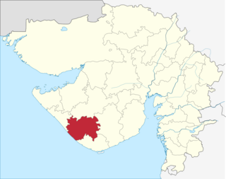
Navsari is an administrative district in the state of Gujarat in India, with its headquarters at Navsari city. The district covers an area of 2,211 square kilometres roughly equal to country like Luxembourg and the US state of Delaware, and had a population of 1,329,672 in 2011 roughly equal to country like Estonia and the US state of Hawaii. The district was formed in 1997 after Valsad district was bifurcated into Valsad and Navsari districts.

Junagadh district district in Gujarat, India

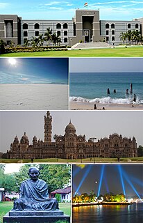
Junagadh District is a district of the Indian state of Gujarat. Its administrative headquarters is the city of Junagadh.

Vairag village in Maharashtra, India

Vairag is a town in Barshi Taluka of Solapur district in Maharashtra, India. The village is located centrally between Solapur and Barshi.

Dhari, Gujarat Village/Town in Gujarat, India

Dhari is a town in Amreli District in Indian state of Gujarat, India.. It is an administrative headquarter of Dhari tehsil. Dhari is most populus village in Amreli District as per census 2011 with 30352 population. Dhari is located on the bank of Shetrunji River, 42 km(26.2 mi) from district head quarter Amreli & 318 km(199.8 mi) from state capital Gandhinagar. It is the birth place of Yogiji Maharaj

Pandegaon is a village in Belgaum district of Karnataka, India. Situated at the bank of Agrani river. Pandegaon is surrounded by Athani Taluka towards South, Miraj Taluka towards west, Jat Taluka towards East, Kavathe-Mahankal Taluka towards north & west.

Pimpalner, Parner Village in Maharashtra, India

Pimpalner, is a small town in Parner Taluka in Ahmednagar district of state of Maharashtra, India. It belongs to Nashik Division. It is located 49 km to the west of District headquarters Ahmednagar. 12 km from Parner. 189 km from State capital Mumbai. Pimpalner is surrounded by Parner Taluka to the north, Ahmednagar Taluka to the east, Shrigonda Taluka to the south, Khed Taluka to the west. Shirur, Ahmednagar, Shrigonda, Manchar are the nearby cities to Pimpalner.

Delvada Village in Gujarat, India

Delvada, also known as Delwada, is a village in Una Taluka, Gir Somnath district, Gujarat, India. It is located on the banks of the Machundri River, 5 km from Una and about 8 km from Diu. Several religious and social groups exist in Delvada. These include: Kolis, Patels, Muslim, Brahmin, Lohana, and Sindhi. Due to its proximity to the Arabian Sea, the weather is extremely humid.

Panchpipla village in Gujarat state, India

Panchpipla is a village of rajkot dist. of Gujarat State. Panchpipla village has used Gujarati language and it is of old cultural villagers.
Nearest city of panchpipla is Jetpur, Dhoraji, Junagadh, Rajkot, Jamkandora and Upleta.

Bhadarva (Bhadarwa) is a village in Savli Taluka in Vadodara District of Gujarat State, India. Bhadarva's pin code is 391780 and postal head office is Bhadarwa.

Visavadar assembly constituency is one of the 182 assembly constituency of Gujarat. It is located in Junagadh District.

Gir Gadhada Taluka taluka in Gujarat, India

Gir Gadhada Taluka is a taluka of Gir Somnath district in the state of Gujarat, India. Before 2013 the area was part of Una Taluka, but it became a taluka in its own right with the creation of Gir Somnath District in August of that year. Gir Gadhada Taluka has population around 15,600. The village of Gir Gadhada became its administrative headquarters.

Barvala-Baval Village in Gujarat, India

Barvala Baval is a small village in Kunkavav Taluka of Amreli district of the Saurashtra region in the Indian state of Gujarat.

Chamardi is a village and former petty Rajput princely state in Valabhipur Taluka of Bhavnagar district, Gujarat, western India.

Indra, Gujarat village in Gujarat, India

Indra is a village in Junagdh District in the state of Gujarat, India. It is located 41 KM towards west from District head quarters Junagadh.

Geratpur railway station

Geratpur railway station is a railway station under Western Railway zone in Gujarat state, India. It serves Geratpur village. Its code is 'GER'. It has 2 platforms. Passenger, MEMU trains halt here.

Munjiyasar village in Gujarat, India

Munjiyasar is a village in Khambha Taluka in Amreli district of Gujarat State, India. It is located 76 kilometres (47 mi) south of the District headquarters Amreli, 8 kilometres (5.0 mi) from Khambha, and 329 kilometres (204 mi) from the State capital Gandhinagar.

Barejadi Nandej railway station

Barejadi Nandej railway station is a railway station under Western Railway zone in Gujarat state, India. Barejadi Nandej railway station is 17 km far away from Ahmedabad railway station. Passenger, MEMU and few Express trains halt at Barejadi Nandej railway station.

References

  1. "Moniya panchayat location and map | Indian Villages". Soki.in. Retrieved 2016-07-21.