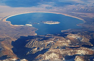
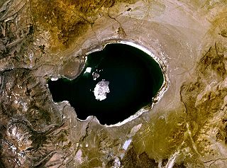
Mono Lake is a saline soda lake in Mono County, California, formed at least 760,000 years ago as a terminal lake in an endorheic basin. The lack of an outlet causes high levels of salts to accumulate in the lake which make its water alkaline.

Mono County is a county located in the east central portion of the U.S. state of California. As of the 2020 census, the population was 13,195, making it the fourth-least populous county in California. The county seat is Bridgeport. The county is located east of the Sierra Nevada between Yosemite National Park and Nevada. The only incorporated town in the county is Mammoth Lakes, which is located at the foot of Mammoth Mountain. Other locations, such as June Lake, are also famous as skiing and fishing resorts. Located in the middle of the county is Mono Lake, a vital habitat for millions of migratory and nesting birds. The lake is located in a wild natural setting, with pinnacles of tufa arising out of the salty and alkaline lake. Also located in Mono County is Bodie, the official state gold rush ghost town, which is now a California State Historic Park.

Owens Lake is a mostly dry lake in the Owens Valley on the eastern side of the Sierra Nevada in Inyo County, California. It is about 5 miles (8.0 km) south of Lone Pine, California. Unlike most dry lakes in the Basin and Range Province that have been dry for thousands of years, Owens held significant water until 1913, when much of the Owens River was diverted into the Los Angeles Aqueduct, causing Owens Lake to desiccate by 1926. A 2004 court order required the LADWP to reestablish a small flow from the river into the lake. Nevertheless, as of 2013, it is the largest single source of dust pollution in the United States.

The California Water Wars were a series of political conflicts between the city of Los Angeles and farmers and ranchers in the Owens Valley of Eastern California over water rights.

The Los Angeles Aqueduct system, comprising the Los Angeles Aqueduct and the Second Los Angeles Aqueduct, is a water conveyance system, built and operated by the Los Angeles Department of Water and Power. The Owens Valley aqueduct was designed and built by the city's water department, at the time named The Bureau of Los Angeles Aqueduct, under the supervision of the department's Chief Engineer William Mulholland. The system delivers water from the Owens River in the Eastern Sierra Nevada Mountains to Los Angeles, California.

The Merced River, in the central part of the U.S. state of California, is a 145-mile (233 km)-long tributary of the San Joaquin River flowing from the Sierra Nevada into the San Joaquin Valley. It is most well known for its swift and steep course through the southern part of Yosemite National Park, where it is the primary watercourse flowing through Yosemite Valley. The river's character changes dramatically once it reaches the plains of the agricultural San Joaquin Valley, where it becomes a slow-moving meandering stream.

The Tuolumne River flows for 149 miles (240 km) through Central California, from the high Sierra Nevada to join the San Joaquin River in the Central Valley. Originating at over 8,000 feet (2,400 m) above sea level in Yosemite National Park, the Tuolumne drains a rugged watershed of 1,958 square miles (5,070 km2), carving a series of canyons through the western slope of the Sierra. While the upper Tuolumne is a fast-flowing mountain stream, the lower river crosses a broad, fertile and extensively cultivated alluvial plain. Like most other central California rivers, the Tuolumne is dammed multiple times for irrigation and the generation of hydroelectricity.

The Walker River is a river in west-central Nevada in the United States, approximately 62 miles (100 km) long. Fed principally by snowmelt from the Sierra Nevada of California, it drains an arid portion of the Great Basin southeast of Reno and flows into the endorheic basin of Walker Lake. The river is an important source of water for irrigation in its course through Nevada; water diversions have reduced its flow such that the level of Walker Lake has fallen 160 feet (49 m) between 1882 and 2010. The river was named for explorer Joseph Reddeford Walker, a mountain man and experienced scout who is known for establishing a segment of the California Trail.

Walker Lake is a natural lake in the Great Basin in western Nevada in the United States. It is 11 mi (17 km) long and 5 mi (8 km) wide, in northwestern Mineral County along the east side of the Wassuk Range, about 75 mi (120 km) southeast of Reno. The lake is fed from the north by the Walker River and has no natural outlet except absorption and evaporation. The community of Walker Lake is found along the southwest shore.

The Owens River is a river in eastern California in the United States, approximately 183 miles (295 km) long. It drains into and through the Owens Valley, an arid basin between the eastern slope of the Sierra Nevada and the western faces of the Inyo and White Mountains. The river terminates at the endorheic Owens Lake south of Lone Pine, at the bottom of a 2,600 sq mi (6,700 km2) watershed.

The Mono Basin is an endorheic drainage basin located east of Yosemite National Park in California and Nevada. It is bordered to the west by the Sierra Nevada, to the east by the Cowtrack Mountains, to the north by the Bodie Hills, and to the south by the north ridge of the Long Valley Caldera.

Rush Creek is a 27.2-mile-long (43.8 km) creek in California on the eastern slope of the Sierra Nevada, running east and then northeast to Mono Lake. Rush Creek is the largest stream in the Mono Basin, carrying 41% of the total runoff. It was extensively diverted by the Los Angeles Aqueduct system in the twentieth century until California Trout, Inc., the National Audubon Society, and the Mono Lake Committee sued Los Angeles Department of Water and Power (LADWP) for continuous low flows in Rush Creek to maintain trout populations in good condition, which was ordered by the court in 1985.
The environment of California describes results of human habitation of the American State of California.
Paoha Island is a volcanic island in Mono Lake, an endorheic lake in the U.S. state of California. The island was formed by a series of eruptions in the 17th century. It is composed of lakebed sediments deposited above volcanic domes. It is one of two major islands in the lake, the other being the smaller Negit Island. Its name comes from a Native American word, Pa-o-ha, describing the abundant hot springs and fumaroles on its surface.

The Audubon Kern River Preserve is a riparian nature reserve owned by the National Audubon Society in the US state of California, near Weldon in Kern County.

The Kucadikadi are a band of Northern Paiute people who live near Mono Lake in Mono County, California. They are the southernmost band of Northern Paiute. The Kutzadika’a have resided in the Mono Lake–Yosemite region since time immemorial.

Lee Vining Creek is a 16.2-mile-long (26.1 km) stream in Mono County, California, flowing into the endorheic basin of Mono Lake. It is the second largest stream flowing into the lake, after Rush Creek.
National Audubon Society v. Superior Court was a key case in California highlighting the conflict between the public trust doctrine and appropriative water rights. The Public Trust Doctrine is based on the principle that certain resources are too valuable to be privately owned and must remain available for public use. In National Audubon Society v. Superior Court, the court held that the public trust doctrine restricts the amount of water that can be withdrawn from navigable waterways. The basis for the Public Trust Doctrine goes back to Roman law. Under Roman law, the air, the rivers, the sea and the seashore were incapable of private ownership; they were dedicated to the use of the public. In essence, the public trust doctrine establishes the role of the state as having trustee environmental duties owed to the public that are subsequently enforceable by the public. There is judicial recognition of this, dictating that certain rights of the public are key to individual common law rights. Judicial recognition of the public trust doctrine has been established for tidelands and non-navigable waterways, submerged land and the waters above them, and preservation of a public interest.

The Chatsworth Nature Preserve (CNP) is a 1,325-acre (536 ha) open-space preserve located in the northwest corner of the San Fernando Valley in Los Angeles, California, United States. The preserve contains oak woodlands, savanna, riparian areas, grassland, vernal pools, and an Ecology Pond, all of which support more than 200 bird species and numerous mammals, amphibians and reptiles.
David Allen Gaines was an American environmentalist and the founder of the Mono Lake Committee. The Mono Lake Committee initiated a lawsuit against the Los Angeles Department of Water and Power to reduce or stop the water diversions that were lowering Mono Lake; Gaines' approach in the lawsuit was to work with the opposition instead of demonizing them. He and his wife, Sally Gaines, began the committee in 1978. They required help from students at Stanford University, UC Davis, UC Santa Cruz, and Earlham College. Based on research in the Mono Basin, he co-wrote a chapter in the book California Riparian Systems; this helped bring scientific attention to the issues at Mono Lake. As a collaborative team, The Mono Lake Committee took a stand against LADWP.
