Montana Trail

Last updated

The Montana Trail was a wagon road that served gold rush towns such as Bannack, Virginia City and later Helena during the Montana gold rush era of the 1860s and 1870s. Miners and settlers all traveled the trail to try to find better lives in Montana. The trail was also utilized for freighting and shipping supplies and food goods to Montana from Utah. American Indians, as well as the weather, were major risks to traveling on the Montana Trail.

Contents

Map of the Montana Trail Map of trail.jpg
Map of the Montana Trail

Immigrants

Montana was a very isolated area and the trail helped to keep Montanans connected to the rest of the United States. Salt Lake City was the only major city between Denver and the Pacific Coast and was a valuable supply and trading center for Montanans. The Montana trail was a much shorter version of the Oregon-California trail. [1] It was one of the only trails to travel north to south, taking supplies from Salt Lake and driving them by pack train to Montana in the north. The trail went across eastern Idaho and passed through the Continental Divide at Monida Pass. [1] The Montana Trail continued north and east through Montana to Fort Benton. It went through Utah, Idaho, and Montana and passed over mountains and crossed streams and valleys. Travel peaked during the mid-summer months when low water levels grounded steamships on the Missouri River.

Mountain men and traders explored the Montana Trail area in the 1840s and developed it in the 1850s and 1860s. [1] In the 1870s miners, traders and settlers utilized the road until its decline in the 1880s. The Montana trail started in Salt Lake City and was an important supply point for the early years of the Montana gold rush. In July 1862, gold was discovered in Montana on Grasshopper Creek in Banack City, in southwest Montana. [1] Grasshopper Creek produced $5 million in gold and some outrageous rumors. [2] People said that they could pull out a sagebrush plant, shake out the roots, and collect a pan's worth of gold. [2]

Immigrants came to Montana in wagons, on horseback, and by foot. They were also able to take steamboats up the Missouri River to Fort Benton during high water months. [2] From there, however, travelers had to take stagecoaches or wagons to the mining camps. [2] Fort Benton boomed as a transportation hub during the high-water months. [2] Many people traveled over overland trails because they were much cheaper than traveling by steamboat. However, this journey was much more difficult. People used pack trains, mule trains, and oxen on the trails. [2]

Interactions with natives

Overland roads followed traditional pathways that Indians had been using for thousands of years. Troubles and raids by the Northern Shoshoni slowed traffic in 1862. [1] The US army halted these raids by establishing Forts to protect American pioneers. Not only were the Shoshoni hostile to freighters and emigrants in Montana, but the Sioux were also especially brutal to the pioneers. Over time, people were able to get military protection along the roads. [3]

In the summer and the fall of 1878, settlers and freighters were fearful of the continuation of the troubles with the Indians. The worst involved freighters and Bannock Indians along the Lost River. In this incident, Indians killed the leader of the freight train as well as five oxen and three horses. [1] In other incidents, Indians burnt haystacks, let stock loose and terrorized pioneers and settlers. [1]

Freighting and trading

Pack train on the trail. AGTM D251 A pack train.png
Pack train on the trail.

The trail was a main supply route for gold camps and created a lucrative trading network during the spring and summer months, generating a fierce competition between several entrepreneurs. One of these entrepreneurs was Benjamin Holladay. A stagecoach magnate, he lowered freight rates until the competition was driven out and then raised them to new heights [1] He was able to drive out the competition by gaining a government subsidy to carry mail. [3] When he realized that trains would drive out his business, he sold his company to Wells, Fargo & Company, which provided a flow of goods, carried passengers, and continued delivering the mail until the Union Central and Pacific Railroad Lines came into the picture. [1] Transporting mail provided most of the company's profit, which made wagon leaders care more about the mail than their passengers, even though the company charged passengers around $150 for the journey. [3] Stage coach companies also carried the mail and transported people to new towns in Montana. [1] Bandits, bad weather and accidents did not stop the flow of goods during the 8 months of the year the trail was opened. [1] Although bandits and indians infested the road and scared the travelers, [1] only blizzards stopped the flow of goods when snow covered Monida Pass.

Mule skinners and bullwhackers

Freighting was one of the main uses of the Montana Trail in the 1860s and 1870s. Freight companies used the Missouri River as well as pack animals to move supplies. Typical pack trains would have 8–12 mules or oxen pulling 3 wagons weighing around 12,000 pounds. [3] In April and May, the weather was more mild and grass would begin to grow as the long pack trains would begin their journeys north. Mule skinners typically rode the left-wheel mule and controlled the lead mule while bullwhackers walked alongside the slower animals, cracking their whips and yelling "Gee!" and "Haw!" [3] The mule skinners and bullwhackers, although respected for their skill at driving the pack trains, were known as heavy drinkers and profane speakers.

Prices of goods

Farmers of the Salt Lake Valley developed a surplus of produce to help meet the demand of the gold rush towns, but as demand grew, farmers, merchants and freighters outstripped the supply. [1] As the population grew in Montana, so did the demand for food like beans and fruit, as well as cloth and other goods. [2] Flour was the most important staple that was transported along the Montana Trail as it was crucial to a healthy diet. Prices for flour and other goods fluctuated widely. Flour could be unsellable because it was too cheap, but four months later there could be no supply and a large demand. During the winter of 1863–1864, heavy snows caused a flour famine which resulted in the "Bread Riot" in Virginia City. [3] Regardless, because of transportation and delivery costs, food was still very expensive. Bad weather and other transportation problems sometimes caused food shortages, and early snows cut off food supplies.

Tolls

Prices were also driven up by the costs of tolls. Tolls were required at many ferries, bridges and roads, but none of these tolls went toward maintaining the roads. [1] Because of the disrepair of the roads, the journey took even longer. However, freighters and travelers had to use the tolls regardless because some of the most dangerous parts of the trail were manned by toll-owners. For example, the Snake River, which runs through Idaho, was very treacherous and scared many freighters and travelers. The expensive cost of tolls, along with the longer travel because of the lack of maintenance of the trail, contributed to higher costs of goods once they reached Montana.

Freight companies

Higher costs for food and other goods were also affected by the freight companies themselves which transported goods along the trail. The Diamond R Freighting Company, based in Virginia City, Montana, [3] was one of the most important companies during the 1870s. Only four trips a year were usually planned by the wagon masters, and the lack of steady service drove up prices. On occasion, the return freight trains would bring rich ores, wools, hides, or furs from Montana. [1] When the freight trains brought trade goods back to Utah, it brought the high costs of goods down slightly in Montana. Fast-freight and express lines were also established, but these services were only available at much higher rates. [1]

Demise of the trail

As the Utah and Northern Railway was introduced to Montana by the Union Pacific, ox teams and pack trains had to compete for customers because of the difference in time and cost. Wagon freighters had to work harder to negotiate new fares. Farmers flocked to the construction sites with teams to help build the rails, earning up to $2.50 a day. [1] The Union Pacific Railroad was determined to get as much freight as possible and entered into contracts with local businesses for freighting on the Utah and Northern Railway. Businesses had trouble finding wagon teams to take goods north because prices dropped as low as $.04 per 100 pounds by June 1878. [1] Because of the rapid increase in the use of trains, wagon teams declined slowly.

By 1879, most people were traveling to Montana by train, via the Union Pacific. Those that could not afford to travel by first or second class in the trains all the way to Montana were told to buy a ticket to Omaha or Lowell and continue their journey by teamster, or ox and wagon. [1] They soon found out, however, that most of these wagons were too full to take them all the way to Montana. [1] Although travel was much faster with the railways, it was still fairly expensive, which helped to keep the stagecoaches in business. This also contributed to the lack of smoothness in the transition from wagon trains to railways. Over time, the use of the trail declined as the railways shortened the trail by over 70 miles and created a much easier and less dangerous route to Montana. The Montana Trail still has a significant part in Montana history.

Related Research Articles

<span class="mw-page-title-main">Oregon Trail</span> Historic route connecting the Missouri River to valleys in Oregon

The Oregon Trail was a 2,170-mile (3,490 km) east–west, large-wheeled wagon route and emigrant trail in the United States that connected the Missouri River to valleys in Oregon. The eastern part of the Oregon Trail spanned part of what is now the state of Kansas and nearly all of what are now the states of Nebraska and Wyoming. The western half of the trail spanned most of the current states of Idaho and Oregon.

<span class="mw-page-title-main">Mountain man</span> Men living remotely in the Rocky Mountains of North America

A mountain man is an explorer who lives in the wilderness and makes his living from hunting and trapping. Mountain men were most common in the North American Rocky Mountains from about 1810 through to the 1880s. They were instrumental in opening up the various emigrant trails allowing Americans in the east to settle the new territories of the far west by organized wagon trains traveling over roads explored and in many cases, physically improved by the mountain men and the big fur companies originally to serve the mule train-based inland fur trade.

<span class="mw-page-title-main">Wagon</span> Four wheeled vehicle (mostly pulled by draught animals)

A wagon or waggon is a heavy four-wheeled vehicle pulled by draught animals or on occasion by humans, used for transporting goods, commodities, agricultural materials, supplies and sometimes people.

<span class="mw-page-title-main">Cow Creek (Montana)</span> River in Montana, United States

Cow Creek is a tributary of the Missouri River, approximately 35 miles (56 km) long, in north central Montana in the United States. Cow Creek rises in the southern foothills of the Bear Paw Mountains in western Blaine County and flows east and then south, joining the Missouri approximately 25 air miles (40 km) northeast of Winifred, Montana—or 22 miles (35 km) upstream from the Fred Robinson Bridge.

<span class="mw-page-title-main">California Trail</span> Historic migration route in the western United States

The California Trail was an emigrant trail of about 1,600 mi (2,600 km) across the western half of the North American continent from Missouri River towns to what is now the state of California. After it was established, the first half of the California Trail followed the same corridor of networked river valley trails as the Oregon Trail and the Mormon Trail, namely the valleys of the Platte, North Platte, and Sweetwater rivers to Wyoming. The trail has several splits and cutoffs for alternative routes around major landforms and to different destinations, with a combined length of over 5,000 mi (8,000 km).

<span class="mw-page-title-main">Powder River Expedition (1865)</span>

The Powder River Expedition of 1865 also known as the Powder River War or Powder River Invasion, was a large and far-flung military operation of the United States Army against the Lakota Sioux, Cheyenne, and Arapaho Indians in Montana Territory and Dakota Territory. Although soldiers destroyed one Arapaho village and established Fort Connor to protect gold miners on the Bozeman Trail, the expedition is considered a failure because it failed to defeat or intimidate the Indians.

<span class="mw-page-title-main">Bozeman Trail</span> Protected area

The Bozeman Trail was an overland route in the Western United States, connecting the gold rush territory of southern Montana to the Oregon Trail in eastern Wyoming. Its most important period was from 1863 to 1868. Despite the fact that the major part of the route in Wyoming used by all Bozeman Trail travelers in 1864 was pioneered by Allen Hurlbut, it was named after John Bozeman. Many miles of the Bozeman Trail in present Montana followed the tracks of Bridger Trail, opened by Jim Bridger in 1864.

<span class="mw-page-title-main">Cariboo Road</span> Historical route in British Columbia, Canada

The Cariboo Road was a project initiated in 1860 by the Governor of the Colony of British Columbia, James Douglas. It involved a feat of engineering stretching from Fort Yale to Barkerville, B.C. through extremely hazardous canyon territory in the Interior of British Columbia.
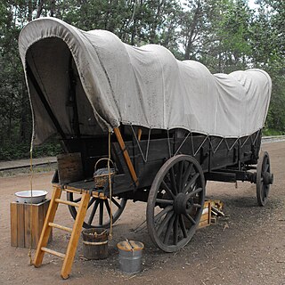
<span class="mw-page-title-main">Covered wagon</span> Wagon used by American pioneers

The covered wagon or prairie wagon, historically also referred to as an ambulance, a whitetop, or a prairie schooner, was a vehicle usually made out of wood and canvas that was used for transportation, prominently in 19th-century America. With roots in the heavy Conestoga wagon developed for the rough, undeveloped roads and paths of the colonial East, the covered wagon spread west with American migration. The Conestoga wagon was far too heavy for westward expansion. Typical farm wagons were merely covered for westward expansion and heavily relied upon along such travel routes as the Great Wagon Road, the Mormon Trail and the Santa Fe and Oregon Trails, covered wagons carried settlers seeking land, gold, and new futures ever farther west.

<span class="mw-page-title-main">Old Spanish Trail (trade route)</span> United States historic place

The Old Spanish Trail is a historical trade route that connected the northern New Mexico settlements of Santa Fe, New Mexico with those of Los Angeles, California and southern California. Approximately 700 mi (1,100 km) long, the trail ran through areas of high mountains, arid deserts, and deep canyons. It is considered one of the most arduous of all trade routes ever established in the United States. Explored, in part, by Spanish explorers as early as the late 16th century, the trail was extensively used by traders with pack trains from about 1830 until the mid-1850s.

<span class="mw-page-title-main">Mormon handcart pioneers</span> 1856–1860 American religious migrants

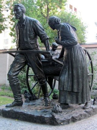
The Mormon handcart pioneers were participants in the migration of members of the Church of Jesus Christ of Latter-day Saints to Salt Lake City, Utah, who used handcarts to transport their belongings. The Mormon handcart movement began in 1856 and continued until 1860.

<span class="mw-page-title-main">Packhorse</span> Horse, mule, donkey, or pony used to carry goods on its back

A packhorse, pack horse, or sumpter refers to a horse, mule, donkey, or pony used to carry goods on its back, usually in sidebags or panniers. Typically packhorses are used to cross difficult terrain, where the absence of roads prevents the use of wheeled vehicles. Use of packhorses dates from the neolithic period to the present day. Today, westernized nations primarily use packhorses for recreational pursuits, but they are still an important part of everyday transportation of goods throughout much of the developing world and have some military uses in rugged regions.

<span class="mw-page-title-main">River Trail (British Columbia)</span>

The River Trail was a main route for travel in the colonial era of what is now the Canadian province of British Columbia, running northwards along the Fraser River from to present day Lillooet to Big Bar, British Columbia and points beyond in the Cariboo District. The route was primarily in use during the Fraser Canyon Gold Rush and associated explorations by prospectors northwards in the search for gold in the Cariboo and Omineca Districts.

<span class="mw-page-title-main">Great Platte River Road</span>

The Great Platte River Road was a major overland travel corridor approximately following the course of the Platte River in present-day Nebraska and Wyoming that was shared by several popular emigrant trails during the 19th century, including the Trapper's Trail, the Oregon Trail, the Mormon Trail, the California Trail, the Pony Express route, and the military road connecting Fort Leavenworth and Fort Laramie. The road, which extended nearly 370 miles (600 km) from the Second Fort Kearny to Fort Laramie, was utilized primarily from 1841 to 1866. In modern times it is often regarded as a sort of superhighway of its era, and has been referred to as "the grand corridor of America's westward expansion".

<span class="mw-page-title-main">Alexander Toponce</span> American pioneer

Alexander Toponce was an American pioneer in the Intermountain West region of the United States. His family immigrated to the United States from Belfort, France when he was seven and Alexander left home about three years later. He worked as a laborer for several years, mostly in the logging and lumber business, before becoming a teamster, stagecoach driver and freight handler. Toponce headed west when he was about fifteen years old, first to Missouri and then to the northern Intermountain West. There, he ran freight and stagecoach outfits, owned livestock herds, sometimes tried his hand at mining, and invested in all manner of development projects. He is credited with opening or improving many early freight and stage routes throughout the region. Later in life, he mostly invested in mining properties while holding interests in land development companies. Over his lifetime, Toponce made and lost several fortunes, the result of bad weather, Indian raids, unpredictable prices and dishonest partners.

The Salt Lake Cutoff is one of the many shortcuts that branched from the California, Mormon and Oregon Trails in the United States. It led northwest out of Salt Lake City, Utah and north of the Great Salt Lake for about 180 miles (290 km) before rejoining the California trail near the City of Rocks, Idaho. From there Oregon Trail travelers could easily travel down the Raft River valley portion of the California Trail to return to the Oregon Trail. It provided a way to stop in Salt Lake City for repairs, fresh supplies, fresh livestock, etc. In later years it was used by tens of thousands of pioneers and miners going east and west on their way to or from the future states of California, Oregon, Utah, Idaho, Montana, Nevada or Washington.

In the history of the American frontier, pioneers built overland trails throughout the 19th century, especially between 1829 and 1870, as an alternative to sea and railroad transport. These immigrants began to settle much of North America west of the Great Plains as part of the mass overland migrations of the mid-19th century. Settlers emigrating from the eastern United States did so with various motives, among them religious persecution and economic incentives, to move from their homes to destinations further west via routes such as the Oregon, California, and Mormon Trails. After the end of the Mexican–American War in 1849, vast new American conquests again encouraged mass immigration. Legislation like the Donation Land Claim Act and significant events like the California Gold Rush further encouraged settlers to travel overland to the west.

<span class="mw-page-title-main">Cow Island, Montana</span>

Cow Island lies in a left turning bend of the Missouri River, in the area known as the Missouri River Breaks. The island is formed by sediments that are seasonally washed out from the mouths of Cow Creek and Bull Creek, which enter the Missouri River just upstream from Cow Island. The island is about 1.2 miles long and averages about 150 yards in width. It is located in extreme northern Fergus County, but lies across the river from extreme southern Blaine County, to its east.

Crowder Canyon, originally Coyote Canyon, is a valley in San Bernardino County, California. Its mouth was at an elevation of 2,999 feet / 914 meters at its confluence with Cajon Canyon. Its source was at an elevation of 4200 feet at 34°21′02″N117°26′04″W near Cajon Summit. The canyon runs southward just west of the top of Cajon Pass then turns southwestward to meet Cajon Canyon.

Mormon Road, also known to the 49ers as the Southern Route, of the California Trail in the Western United States, was a seasonal wagon road pioneered by a Mormon party from Salt Lake City, Utah led by Jefferson Hunt, that followed the route of Spanish explorers and the Old Spanish Trail across southwestern Utah, northwestern Arizona, southern Nevada and the Mojave Desert of California to Los Angeles in 1847. From 1855, it became a military and commercial wagon route between California and Utah, called the Los Angeles – Salt Lake Road. In later decades this route was variously called the "Old Mormon Road", the "Old Southern Road", or the "Immigrant Road" in California. In Utah, Arizona and Nevada it was known as the "California Road".

References

  1. 1 2 3 4 5 6 7 8 9 10 11 12 13 14 15 16 17 18 19 20 Madsen, Betty and Brigham (1980). North to Montana : Jehus, Bullwackers, and Mule Skinners on the Montana Trail. Salt Lake City, Utah: University of Utah Press.
  2. 1 2 3 4 5 6 7 Holmes, Krys (2008). Montana: Stories of the Land. Helena, Montana: Montana Historical Society Press.
  3. 1 2 3 4 5 6 7 Malone, Michael (1976). Montana: A History of 2 Centuries. University of Washington Press.

Commons-logo.svg Media related to Montana Trail at Wikimedia Commons