Beaverhead County is the largest county by area in the U.S. state of Montana. As of the 2020 census, the population was 9,371. Its county seat is Dillon. The county was founded in 1865.

Clark County is a rural county in the U.S. state of Idaho; its county seat and largest city is Dubois. As of the 2020 Census, the county had a population of 790, making it the least populous county in the state.
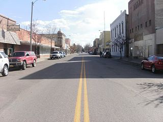
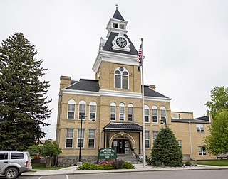
Dillon is a city in and the county seat of Beaverhead County, Montana, United States. The population was 3,880 at the 2020 census. The city was named for Sidney Dillon (1812–1892), president of Union Pacific Railroad.

The Continental Divide National Scenic Trail is a United States National Scenic Trail with a length measured by the Continental Divide Trail Coalition of 3,028 miles (4,873 km) between the U.S. border with Chihuahua, Mexico and the border with Alberta, Canada. Frequent route changes and a large number of alternate routes result in an actual hiking distance of 2,700 miles (4,300 km) to 3,150 miles (5,070 km). The CDT follows the Continental Divide of the Americas along the Rocky Mountains and traverses five U.S. states — Montana, Idaho, Wyoming, Colorado, and New Mexico. In Montana near the Canadian border the trail crosses Triple Divide Pass.

The Bitterroot Range is a mountain range and a subrange of the Rocky Mountains that runs along the border of Montana and Idaho in the northwestern United States. The range spans an area of 24,223 square miles (62,740 km2) and is named after the bitterroot, a small pink flower that is the state flower of Montana.

Lemhi Pass is a high mountain pass in the Beaverhead Mountains, part of the Bitterroot Range in the Rocky Mountains and within Salmon-Challis National Forest. The pass lies on the Montana-Idaho border on the continental divide, at an elevation of 7,373 feet (2,247 m) above sea level. It is accessed via Lemhi Pass Road in Montana, and the Lewis and Clark Highway in Idaho, both dirt roads. Warm Springs Road, which roughly follows the divide in Montana, passes just west of the pass's high point.
The Beaverhead–Deerlodge National Forest is the largest of the National Forests in Montana, United States. Covering 3.36 million acres (13,600 km2), the forest is broken into nine separate sections and stretches across eight counties in the southwestern area of the state. President Theodore Roosevelt named the two forests in 1908 and they were merged in 1996. Forest headquarters are located in Dillon, Montana. In Roosevelt's original legislation, the Deerlodge National Forest was called the Big Hole Forest Reserve. He created this reserve because the Anaconda Copper Mining Company, based in Butte, Montana, had begun to clearcut the upper Big Hole River watershed. The subsequent erosion, exacerbated by smoke pollution from the Anaconda smelter, was devastating the region. Ranchers and conservationists alike complained to Roosevelt, who made several trips to the area. (Munday 2001)
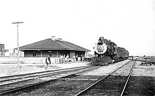
The Gilmore and Pittsburgh Railroad (G&P), now defunct, was an American railroad located in southwestern Montana and east-central Idaho. Constructed in 1909 and 1910 between Armstead, Montana, and Salmon, Idaho, the G&P served mining and agricultural areas in Lemhi County, Idaho, and Beaverhead County, Montana. The line was financially backed by the Northern Pacific Railway (NP) and later became its subsidiary. Never financially successful, the G&P ceased operations in 1939, and the railroad was dismantled the following year.

Interstate 70 (I-70) is a mainline route of the Interstate Highway System in the United States connecting Utah and Maryland. The Utah section runs east–west for approximately 232 miles (373 km) across the central part of the state. Richfield is the largest Utah city served by the freeway, which does not serve or connect any urban areas in the state. The freeway was built as part of a system of highways connecting Los Angeles and the Northeastern United States. I-70 was the second attempt to connect southern California to the east coast of the United States via central Utah, the first being a failed attempt to construct a transcontinental railroad. Parts of that effort were reused in the laying out of the route of I-70.

Interstate 15 (I-15) is a part of the Interstate Highway System that runs from San Diego, California, to Sweetgrass, Montana. In Idaho, the Interstate Highway runs exactly 196 miles (315 km) from the Utah state line near Woodruff north to the Montana state line at Monida Pass. I-15 is the primary north–south highway of Eastern Idaho. The Interstate Highway connects Pocatello and Idaho Falls, the fourth and fifth largest cities in Idaho, and the smaller county seats of Malad City, Blackfoot, and Dubois. I-15 connects all of those cities with Salt Lake City to the south and Butte to the north. The Interstate has business loops through McCammon, Inkom, Pocatello, Blackfoot, and Idaho Falls.

Interstate 90 (I-90) is a transcontinental Interstate Highway that runs east–west across the northern United States. Within the state of Idaho, the freeway travels for 74 miles (119 km) from the Washington border near Spokane to Coeur d'Alene and the panhandle region at the north end of the state. After traveling through the Silver Valley along the Coeur d'Alene River in the Bitterroot Range, I-90 crosses into Montana at Lookout Pass.

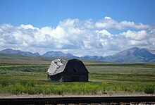
Monida is an unincorporated community in Beaverhead County, Montana, United States. Monida is located on Interstate 15 at the top of Monida Pass, 14.7 miles (23.7 km) east-southeast of Lima. The community is situated on the Continental Divide at the Idaho state line. It has a permanent population of two. It also serves as the southernmost settlement in the state.

The Centennial Mountains are the southernmost sub-range of the Bitterroot Range in the U.S. states of Idaho and Montana. The Centennial Mountains include the Western and Eastern Centennial Mountains. The range extends east from Monida Pass along the Continental Divide to Henrys Fork 48 km (30 mi) NNW of Ashton, Idaho; bounded on the west by Beaver Creek, on the north by Centennial Valley and Henrys Lake Mountains, on the east by Henrys Lake Flat, and on the south by Shotgun Valley and the Snake River Plain. The highest peak in the range is Mount Jefferson.

The Beaverhead Mountains, highest point Scott Peak, el. 11,393 feet (3,473 m), are a mountain range straddling the Continental Divide in the U.S. states of Montana and Idaho. They are a sub-range of the Bitterroot Range, and divide Beaverhead County, Montana from Lemhi County, Idaho and Clark County, Idaho.

Bannock Pass is a high mountain pass in the Beaverhead Mountains, part of the Bitterroot Range in the Rocky Mountains. The pass lies on the Montana-Idaho border on the Continental Divide, at an elevation of 7,684 feet (2,342 m) above sea level.
Deer Lodge Pass, elevation 5,879 ft (1,792 m), is a mountain pass on the Continental Divide in southwestern Montana, about 11 miles southwest of Butte. It is traversed by Interstate 15 and is one of three crossings of the Divide by I-15, the others being Monida Pass and Elk Park Pass north of Butte. Unlike most other passes in western Montana, Deer Lodge Pass is in the midst of treeless, rolling hills, and the grades on the highway are relatively gentle.
Elk Park Pass, elevation 6,352 ft (1,936 m), is a mountain pass on the Continental Divide in southwestern Montana, about 4 miles (6.4 km) northeast of Butte. It is traversed by Interstate 15 and is one of three crossings of the Divide by the Interstate, the others being Monida Pass and Deer Lodge Pass southwest of Butte. Elk Park Pass lies on the border between Silver Bow and Jefferson counties and is remarkable for its highly asymmetrical nature. The approach from the north is through namesake Elk Park, a high, mostly treeless plain, and the grade is almost imperceptible. The elevation at the northeast end of the park, about 10 miles (16 km) from the pass, is about 6,200 ft (1,900 m), only 152 ft (46 m) lower than the pass itself. However, at the south end, the highway drops 750 ft (230 m) from the pass into Butte over a distance of only about 4 miles (6.4 km).
Beaver Creek is a 58-mile (93 km) long tributary of Camas Creek in the U.S. state of Idaho. Beginning at an elevation of 7,367 feet (2,245 m) near Monida Pass in northern Clark County, it flows generally south through the communities of Humphrey, Spencer, and Dubois. Continuing into Jefferson County, it reaches its mouth north of the town of Hamer, at an elevation of 4,810 feet (1,466 m). It is roughly paralleled by Interstate 15 for its entire length.

Transportation in Montana comprises many different forms of travel. Montana shares a long border with Canada, hence international crossings are prevalent in the northern section of the state; there are 13 road crossings and one rail crossing.