Description
Monte Massico is an Italian mountain ridge. In antiquity, it was described as being in the territory of the Aurunci, and on the border of Campania and Latium Adiectum, but attributed by most authors to the latter.
It projects south-west from the volcanic system of Rocca Monfina (see Suessa Aurunca) as far as the sea, and separates the lower course of the Liris from the plain of Campania. It consists of limestone, with a superstratum of pliocenic and volcanic masses, and was once an island; its highest point is 811 meters (2661 feet) above sea-level.
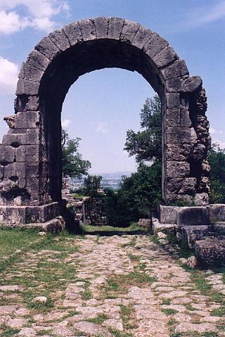
It was famous for its Falernian wine in ancient times. There was just room along the coast for the road to pass through; the pass was guarded by the Auruncan town of Vescia (probably on the mountain side), which ceased to exist in 314 BC after the defeat of the Ausones, but left its name to the spot. Its successor, Sinuessa, on the coast, a station on the Via Appia, was constructed in 312 BC, and a colony was founded there in 295 BC.
It was mentioned by classical writers as a place in which travellers halted. Here Virgil joined Horace on the famous journey to Brundisium. Domitian considerably increased its importance by the construction of the Via Domitiana, which left the Via Appia here and ran to Cumae and Puteoli, and it was he, no doubt, who raised it to the position of colonia Flavia. The town was destroyed by the Saracens, but some ruins of it are still visible two miles north-west of the modern village of Mondragone - the mineral springs which still rise here were frequented in antiquity.

Lipari is a comune including six of seven islands of the Aeolian Islands and it is located in the Tyrrhenian Sea off the northern coast of Sicily, southern Italy; it is administratively part of the Metropolitan City of Messina. Its population is 12,821, but during the May to September tourist season, the total population may reach up to 20,000. It is also the name of the biggest island in the archipelago, where the main urban area of the comune is located.

The Appian Way is one of the earliest and strategically most important Roman roads of the ancient republic. It connected Rome to Brindisi, in southeast Italy. Its importance is indicated by its common name, recorded by Statius, of Appia longarum... regina viarum.
Capua is a city and comune in the province of Caserta, in the region of Campania, southern Italy, situated 25 km (16 mi) north of Naples, on the northeastern edge of the Campanian plain.

The Apennines or Apennine Mountains are a mountain range consisting of parallel smaller chains extending c. 1,200 km (750 mi) along the length of peninsular Italy. In the northwest they join with the Ligurian Alps at Altare. In the southwest they end at Reggio di Calabria, the coastal city at the tip of the peninsula. Since 2000 the Environment Ministry of Italy, following the recommendations of the Apennines Park of Europe Project, has been defining the Apennines System to include the mountains of north Sicily, for a total distance of 1,500 kilometres (930 mi). The system forms an arc enclosing the east side of the Ligurian and Tyrrhenian Seas.
The Via Flaminia or Flaminian Way was an ancient Roman road leading from Rome over the Apennine Mountains to Ariminum (Rimini) on the coast of the Adriatic Sea, and due to the ruggedness of the mountains was the major option the Romans had for travel between Etruria, Latium, Campania, and the Po Valley. The section running through northern Rome is where Constantine the Great had his famous vision of the Chi Rho, leading to his conversion to Christianity and the Christianization of the Roman Empire.

Montferrat is a historical region of Piedmont in northern Italy. It comprises roughly the modern provinces of Alessandria and Asti. Montferrat is one of the most important wine districts of Italy. It also has a strong literary tradition, including the 18th century Asti-born poet and dramatist Vittorio Alfieri and the Alessandrian Umberto Eco.
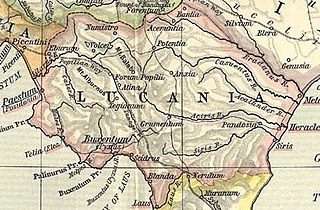
Lucania was a historical region of Southern Italy. It was the land of the Lucani, an Oscan people. It extended from the Tyrrhenian Sea to the Gulf of Taranto.
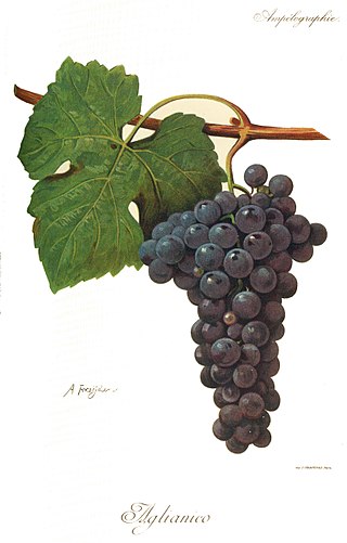
Aglianico is a black grape grown in the southern regions of Italy, mostly Basilicata and Campania. It is considered with Sangiovese and Nebbiolo to be one of the three greatest Italian varieties. Aglianico is sometimes called "The Barolo of the South" due to its ability to produce highly refined, complex fine wines like the famous wine from Piedmont, Barolo.

Terracina is an Italian city and comune of the province of Latina, located on the coast 56 km (35 mi) southeast of Rome on the Via Appia. The site has been continuously occupied since antiquity.

Salina is one of the Aeolian Islands north of Sicily, southern Italy. It is the second largest island in the archipelago.

Sessa Aurunca is a town and comune in the province of Caserta, Campania, southern Italy. It is located on the south west slope of the extinct volcano of Roccamonfina, 40 kilometres (25 mi) by rail west north west of Caserta and 30 kilometres (19 mi) east of Formia.
Suessula was an ancient city of Campania, southern Italy, situated in the interior of the peninsula, near the frontier with Samnium, between Capua and Nola, and about 7 km northeast of Acerrae, Suessula is now a vanished city and the archeological site belongs to the city of Acerra, and not to San Felice a Cancello as reported in some sources.

Ariccia is a town and comune in the Metropolitan City of Rome, central Italy, 25 kilometres (16 mi) southeast of Rome. It is in the Alban Hills of the Lazio (Latium) region and could be considered an extension of Rome's southeastern suburbs. One of the Castelli Romani towns, Ariccia is located in the regional park known as the "Parco Regionale dei Castelli Romani".
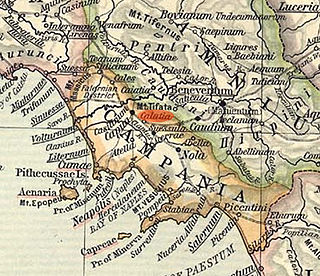
Cālātia was an ancient town of Campania, southern Italy, c. 10 km southeast of Capua, on the Via Appia, near the point where the Via Popillia branches off from it. It is represented by a locality known as Villa Galazia and by the church of San Giacomo alle Galazze, within the modern town of Maddaloni, very near the boundary with the neighboring town of San Nicola la Strada, and right on the Via Appia. The Via Appia here, as at Capua, abandons its former SE direction for a length of 2,000 Oscan feet (500 m), for which it runs due east and then resumes its course SE. Ruins include remains of the walls and the pre-Roman necropolis was partially excavated in 1882. The ten shafts lined with slabs of tuff which may have been the approaches to tombs or may have served as wells.
The Hirpini were an ancient Samnite tribe of Southern Italy. While generally regarded as having been Samnites, sometimes they are treated as a distinct and independent nation. They inhabited the southern portion of Samnium, in the more extensive sense of that name, roughly the area now known as Irpinia from their name—a mountainous region bordering on Basilicata towards the south, on Apulia to the east, and on Campania towards the west. No marked natural boundary separated them from these neighboring nations, but they occupied the lofty masses and groups of the central Apennines, while the plains on each side, and the lower ranges that bounded them, belonged to their more fortunate neighbors. The mountain basin formed by the three tributaries of the Vulturnus —the Tamarus, Calor, and Sabatus, which, with their valleys, unite near Beneventum, surrounded on all sides by lofty and rugged ranges of mountains—is the center and heart of their territory. They occupied the Daunian Mountains to the north, while its more southern portion comprised the upper valley of the Aufidus and the lofty group of mountains where that river takes its rise.

Latium adiectum or Latium Novum was a region of Roman Italy between Monte Circeo and the river Garigliano, south of and immediately adjacent to Old Latium, hence its name of attached Latium.
Falernian was a strong white wine popular in the classical Roman period, produced from Aglianico grapes on the slopes of Mount Falernus near the border of Latium and Campania. From here, Falernian wine grew in popularity, becoming the one of the most highly regarded wines accessible to and consumed by the ancient Romans. In an Epyllion written in c.92 AD, Silius Italicus, a prominent Roman senator, attributed its origin to a chance meeting between a mythic pauper named Falernus, who was said to have lived on Mount Falernus in the late 3rd century BC, and Liber, the Roman god of viticulture. Considered a "first growth" or "cult wine" for its time, it was often mentioned in Roman literature, but disappeared after the classical period. There were three vineyards recognized by Romans: Caucinian Falernian from the vineyards on the highest slopes of Mount Falernus; Faustian Falernian, the most famous, from land on the central slopes corresponding to the current hilly areas of the town of Falciano del Massico and Carinola di Casanova, owned by Faustus, son of the Roman dictator Sulla; and wine from the lower slopes and plain that was simply called Falernian. The area is now occupied by the modern day vineyards of Rocca di Mondragone and Monte Massico.
Greco is an Italian wine grape that may be of Greek origin. The name relates to both white (Greco bianco) and black (Greco nero) grape varieties. While there is more land area dedicated to Greco nero, the Greco bianco is the grape most commonly referred to by "Greco". In the Campania region it is used to produce the Denominazione di Origine Controllata e Garantita (DOCG) wine Greco di Tufo. In Calabria, it is used to make the Denominazione di Origine Controllata (DOC) wine Greco di Bianco. The name "Greco" is sometimes used as a synonym for several varieties of supposed Greek origins-most notably Trebbiano.
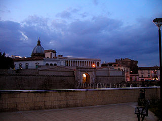
Sinuessa was a city of Latium, in the more extended sense of the name, situated on the Tyrrhenian Sea, about 10 km north of the mouth of the Volturno River. It was on the line of the Via Appia, and was the last place where that great highroad touched on the sea-coast. The ruins of the city are located in the modern-day municipality of Mondragone, Campania, Italy.
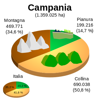
The geography of Campania illustrates the geographical characteristics of Campania, a region of Italy.
