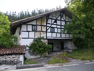
Munitibar-Arbatzegi Gerrikaitz is a town and municipality located in the province of Biscay, in the autonomous community of Basque Country, northern Spain.
The Stadio Leonardo Garilli is a multi-use stadium in Piacenza, Italy. It is currently used mostly for football matches and the home of Piacenza Calcio 1919 and from 2014 also those of Pro Piacenza 1919. The stadium was built in 1969 and was renovated in 1993 passing from 12,000 to the current 21,668 when the former Piacenza were promoted.

Saanichton, British Columbia is a village, in the municipality of Central Saanich, located between Victoria and the BC Ferry Terminal, west of the Pat Bay Highway, at the junction of Mount Newton Cross Road and East Saanich Road.

Baqên County is a county within Nagqu of the Tibet Autonomous Region. The seat of the county is Baqên Town.

Torre del Bierzo is a village and municipality in the region of El Bierzo. According to the 2004 census (INE), the municipality has a population of 2,736 inhabitants.

Norashen is a village in the Ararat Province of Armenia. It is located adjacent to the ruins of the ancient city of Dvin.
Piggen is an unincorporated community in Accomack County, Virginia.
Podłęże is a village in the administrative district of Gmina Świnice Warckie, within Łęczyca County, Łódź Voivodeship, in central Poland. It lies approximately 9 kilometres (6 mi) east of Świnice Warckie, 12 km (7 mi) west of Łęczyca, and 41 km (25 mi) north-west of the regional capital Łódź.
Güvəndik is a village in the Tovuz Rayon of Azerbaijan. The village forms part of the municipality of Papaqçılar.
Derebeyli is a village in the Goygol Rayon of Azerbaijan.
Toporów is a village in the administrative district of Gmina Cmolas, within Kolbuszowa County, Subcarpathian Voivodeship, in south-eastern Poland. It lies approximately 12 kilometres (7 mi) west of Cmolas, 15 km (9 mi) north-west of Kolbuszowa, and 43 km (27 mi) north-west of the regional capital Rzeszów.

Jaszów is a village in the administrative district of Gmina Grodków, within Brzeg County, Opole Voivodeship, in south-western Poland. It lies approximately 14 kilometres (9 mi) south-west of Grodków, 35 km (22 mi) south-west of Brzeg, and 50 km (31 mi) west of the regional capital Opole.

Urbanowice is a village in the administrative district of Gmina Pawłowiczki, within Kędzierzyn-Koźle County, Opole Voivodeship, in south-western Poland. It lies approximately 6 kilometres (4 mi) north of Pawłowiczki, 14 km (9 mi) south-west of Kędzierzyn-Koźle, and 42 km (26 mi) south of the regional capital Opole.
Orzechówko is a settlement in the administrative district of Gmina Barczewo, within Olsztyn County, Warmian-Masurian Voivodeship, in northern Poland.
Karwiagać is a village in the administrative district of Gmina Kalisz Pomorski, within Drawsko County, West Pomeranian Voivodeship, in north-western Poland. It lies approximately 9 kilometres (6 mi) east of Kalisz Pomorski, 32 km (20 mi) south-east of Drawsko Pomorskie, and 98 km (61 mi) east of the regional capital Szczecin.
Lisie Pole is a village in the administrative district of Gmina Chojna, within Gryfino County, West Pomeranian Voivodeship, in north-western Poland, close to the German border. It lies approximately 8 kilometres (5 mi) north of Chojna, 25 km (16 mi) south of Gryfino, and 44 km (27 mi) south of the regional capital Szczecin.
Stubal is a village in the municipality of Vladičin Han, Serbia. According to the 2002 census, the village has a population of 1113 people.
Orokenda was a town in ancient Pamphylia, inhabited during Roman times. Its name does not occur in ancient authors, but is inferred by epigraphic and other evidence.
Badgertown is an unincorporated community in Goshen Township, Belmont County, Ohio, northwest of Bethesda. It appeared on the 1888 H. C. Mead & Co. map of Goshen Township, although has since been mostly absorbed by Bethesda.
Ələsgərli is a ghost village on the river Zəyəmçay in the Fuzuli District of Azerbaijan. It is set on undulating land, some 7km due east of Fuzuli town, backed by more substantial mountain foothills. Video footage released after its 2020 recapture by Azerbaijani forces show an intact metalled road running through an otherwise devastated settlement of widely spaced farmhouses that have long ago fallen into crumbling ruins.


