Montes Caucasus

Last updated
Montes Caucasus
Montes Caucasus AS15-M-1536.jpg
Oblique view facing north from 106 km altitude of the southern Montes Caucasus, from Apollo 15
Highest point
Listing Lunar mountains
Coordinates 38°24′N10°00′E / 38.4°N 10.0°E / 38.4; 10.0 [1]
Geography
Locationthe Moon
Montes Caucasus and closer structures with mineral postprocessing Aldo Ferruggia - Lacus Mortis.jpg
Montes Caucasus and closer structures with mineral postprocessing
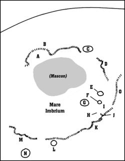
Detail map of Mare Imbrium's features. Montes Caucasus is marked "O". Imbrium map.png
Detail map of Mare Imbrium's features. Montes Caucasus is marked "O".

Montes Caucasus is a rugged range of mountains in the northeastern part of the Moon. [2] It begins at a gap of level surface that joins the Mare Imbrium to the west with the Mare Serenitatis to the east, and extends in an irregular band to the north-northeast to the western side of the prominent crater Eudoxus. The range forms the northwestern boundary of the Mare Serenitatis. It forms a continuation of the Montes Apenninus range to the southwest. [3]

Contents

There are several breaks in the range where nearby lunar mare has intruded into the formation, particularly near the southern tip. Embedded within the eastern flank of the range is the crater Calippus. Along the eastern flank to the south of Eudoxus is the remnants of the crater Alexander.

The selenographic coordinates of this range are 38.4° N, 10.0° E, and it has an official diameter of 445 km. [1] However some observers list the length as being up to 550 km. The tallest peaks in this range reach heights of 6 km, undoubtedly providing an expansive view of the surroundings from their tops.

The range was named after the Caucasus Mountains on Earth by the German selenographer Johann H. Mädler. However, none of the peaks in this range has been assigned individual names, at least officially.

See also

View of the limb of the moon showing Montes Apenninus (left), Montes Caucasus (right), eastern Mare Imbrium (top), and western Mare Serenitatis (bottom), from Apollo 11 Montes Apenninus Montes Caucasus AS11-44-6665HR.jpg
View of the limb of the moon showing Montes Apenninus (left), Montes Caucasus (right), eastern Mare Imbrium (top), and western Mare Serenitatis (bottom), from Apollo 11

Related Research Articles

<span class="mw-page-title-main">Mare Serenitatis</span> Lunar mare

Mare Serenitatis is a lunar mare located to the east of Mare Imbrium on the Moon. Its diameter is 674 km (419 mi).

<span class="mw-page-title-main">Montes Haemus</span> Mountain range on the Moon

Montes Haemus is a mountain range that forms the southwestern edge of the Mare Serenitatis basin on the Moon. They form a less prominent mirror image of the Montes Apenninus range to the west, and curve up to nearly join at the northern end. The eastern edge terminates with the Promontorium Archerusia, to the northwest of the crater Plinius. This end reaches a gap where the Mare Serenitatis to the north joins the Mare Tranquillitatis to the south.

<span class="mw-page-title-main">Aristoteles (crater)</span> Crater on the Moon

Aristoteles is a lunar impact crater that lies near the southern edge of the Mare Frigoris and to the east of the Montes Alpes mountain range. It was officially named in 1935 after the ancient Greek philosopher Aristotle by the International Astronomical Union, using the classical form of his name.

<span class="mw-page-title-main">Menelaus (crater)</span> Crater on the Moon

Menelaus is a young lunar impact crater located on the southern shore of Mare Serenitatis near the eastern end of the Montes Hæmus mountain range. Its diameter is 27 km. To the southwest is the small crater Auwers, and to the west-southwest is the even smaller Daubrée. To the northeast is a faint rille system named the Rimae Menelaus.

<span class="mw-page-title-main">Banting (crater)</span> Lunar impact crater

Banting is a small, bowl-shaped lunar impact crater located near the middle of the Mare Serenitatis on the Earth's moon.

<span class="mw-page-title-main">Aratus (crater)</span> Crater on the Moon

Aratus is a small lunar impact crater located on the highland to the south and east of the rugged Montes Apenninus range. It is a circular, cup-shaped crater with a relatively high albedo. It was named after Greek astronomer Aratus of Soli. To the east is the Mare Serenitatis, and to the southwest is the somewhat larger crater Conon. North-northeast of Aratus is the landing site of the Apollo 15 mission, just beyond Mons Hadley Delta.

<span class="mw-page-title-main">Eudoxus (lunar crater)</span> Crater on the Moon

Eudoxus is a prominent lunar impact crater that lies to the east of the northern tip of the Montes Caucasus range. It is named after the Greek astronomer Eudoxus of Cnidus. It is located to the south of the prominent crater Aristoteles in the northern regions of the visible Moon. To the south is the ruined formation of Alexander, and the small crater Lamèch lies to the southwest.

<span class="mw-page-title-main">Alexander (crater)</span> Crater on the Moon

Alexander is a lunar impact crater-like feature in the rugged surface to the north of Mare Serenitatis. It lies to the south-southwest of the prominent crater Eudoxus, and to the east-northeast of Calippus. It was named after Alexander the Great.

<span class="mw-page-title-main">Calippus (crater)</span> Crater on the Moon

Calippus is a small lunar impact crater that is located on the eastern edge of the rugged Montes Caucasus mountain range in the northern part of the Moon. It was named after Greek astronomer Callippus of Cyzicus. It lies to the southwest of the crater remnant Alexander, to the northwest of the Mare Serenitatis.

<span class="mw-page-title-main">Montes Alpes</span> Mountain range on the Moon

Montes Alpes is a mountain range in the northern part of the Moon's near side. It was named after the Alps in Europe; the name was confirmed by the International Astronomical Union in 1935. It lies between the selenographic coordinates latitudes 52.81°N and 42.04°N, and longitudes 5.6°W and 3.22°E. The range thus crosses the lunar prime meridian, and is partially illuminated and partially in shadow during first and last quarters. The center of the range is at 48.36°N, 0.58°W, and has a diameter of 334 km.

<span class="mw-page-title-main">Santos-Dumont (crater)</span> Lunar crater

Santos-Dumont is a small lunar impact crater that lies in the northern end of the Montes Apenninus range at the eastern edge of the Mare Imbrium. It is located about 30 kilometers to the northeast of Mons Hadley, a mountain massif.

<span class="mw-page-title-main">Lacus Somniorum</span> Feature on the moon

Lacus Somniorum is a basaltic plain located in the northeastern part of the Moon's near side. It is located at selenographic coordinates 37.56° N, 30.8° E, and has a diameter of 424.76 kilometers. The name is Latin for Lake of Dreams, a title given to this feature by Giovanni Riccioli. It is the largest of the lunar features designated Lacus.

<span class="mw-page-title-main">Montes Cordillera</span> Mountain range on the Moon

Montes Cordillera is a mountain range on the Moon. This feature forms the outer wall of peaks that surround the Mare Orientale impact basin, the inner ring being formed by the Montes Rook. The center of the range is located at selenographic coordinates 17.5° S, 81.6° W, and the diameter is 574 km (357 mi).

<span class="mw-page-title-main">Mons Piton</span> Mountain on the Moon

Mons Piton is an isolated lunar mountain that is located in the eastern part of the Mare Imbrium, to the north-northwest of the crater Aristillus. Due east of Mons Piton is the flooded crater Cassini, and to the west-northwest lies Piazzi Smyth. North and northeast of this massif is the Montes Alpes range, forming the northeast edge of the lunar mare.

<span class="mw-page-title-main">Montes Rook</span> Mountain range on the Moon

Montes Rook is a ring-shaped mountain range that lies along the western limb of the Moon, crossing over to the far side. It completely encircles the Mare Orientale, and forms part of a massive impact basin feature. This range in turn is encircled by the larger Montes Cordillera, which is separated from the Montes Rook by a rugged, ring-shaped plain.

<span class="mw-page-title-main">Montes Taurus</span> Mountainous region on the Moon

Montes Taurus is a rugged, jumbled mountainous region on the Moon. It is located to the east of the Mare Serenitatis, in the northeastern quadrant of the Moon's near side. Coordinates of their center are 27.32°N 40.34°E, and their extent is about 170 km.

<span class="mw-page-title-main">Taurus–Littrow</span> Lunar valley

Taurus–Littrow is a lunar valley located on the near side at the coordinates 20.0°N 31.0°E. It served as the landing site for the American Apollo 17 mission in December 1972, the last crewed mission to the Moon. The valley is located on the southeastern edge of Mare Serenitatis along a ring of mountains formed between 3.8 and 3.9 billion years ago when a large object impacted the Moon, forming the Serenitatis basin and pushing rock outward and upward.

<span class="mw-page-title-main">Montes Apenninus</span> Mountain range on the Moon

Montes Apenninus are a rugged mountain range on the northern part of the Moon's near side. They are named after the Apennine Mountains in Italy. With their formation dating back about 3.9 billion years, Montes Apenninus are fairly old.

<span class="mw-page-title-main">Montes Carpatus</span> Mountain range on the Moon

Montes Carpatus is a mountain range that forms the southern edge of the Mare Imbrium on the Moon. The selenographic coordinates of this range are 14.5° N, 24.4° W, and the formation has an overall diameter of 361 km (224 mi). They were named by astronomer Johann Heinrich von Mädler after the Carpathian Mountains in Central Europe.

<span class="mw-page-title-main">Hadley–Apennine</span> Moon landing site of American Apollo 15

Hadley–Apennine is a region on the near side of Earth's Moon that served as the landing site for the American Apollo 15 mission, the fourth crewed landing on the Moon and the first of the "J-missions", in July 1971. The site is located on the eastern edge of Mare Imbrium on a lava plain known as Palus Putredinis. Hadley–Apennine is bordered by the Montes Apenninus, a mountain range, and Hadley Rille, a meandering channel, on the east and west, respectively.

References

  1. 1 2 "Montes Caucasus". Gazetteer of Planetary Nomenclature. USGS Astrogeology. Retrieved 2010-08-26.
  2. "Moon Map". Observatorio ARVAL. Retrieved 2010-08-26.
  3. "Montes Caucasus on BBC".