Montes Riphaeus is an irregular range of lunar mountains that lie along the west-northwestern edge of Mare Cognitum, on the southeastern edge of Oceanus Procellarum. The range trends generally from north-northeast to south-southwest. It includes a number of slender ridge lines with valleys flooded by intruding flows of lava.

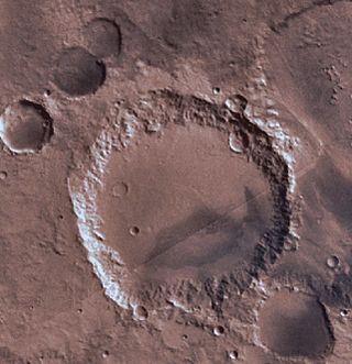
Beer is a crater lying situated within the Margaritifer Sinus quadrangle (MC-19) region of the planet Mars, named in honor of the German astronomer, Wilhelm Beer. It is located at 14.4°S 351.8°E.

Mädler is a crater on Mars. It was named in honor of the German astronomer Johann Heinrich Mädler by the IAU in 1973.

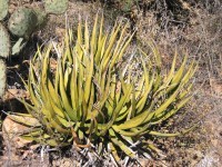
The Lechuguilla Desert is a small desert located in southwestern Arizona near the U.S.-Mexico border. It is considered to be part of the Lower Colorado Valley region of the Sonoran Desert. It lies in a north–south direction between the Gila Mountains and the Cabeza Prieta Mountains, and almost entirely in the Barry M. Goldwater Air Force Range. The desert is named after the lechuguilla plant, known scientifically as Agave lecheguilla, which occurs exclusively in the Chihuahuan desert many hundreds of miles to the east. The desert is also on the north border of the Gran Desierto de Altar of Sonora, Mexico.

The Cordillera de Mérida is a series of mountain ranges, or massif, in northwestern Venezuela. The Cordillera de Mérida is a northeastern extension of the Andes Mountains and the most important branch of the Venezuelan Andes. The ranges run southwest–northeast between the Venezuelan-Colombian border and the Venezuelan Coastal Ranges. The Táchira depression separates the Cordillera de Mérida from the Cordillera Oriental, which forms the Colombia-Venezuela border.

The Tinajas Altas Mountains are an extremely arid northwest–southeast trending mountain range in southern Yuma County, Arizona, approximately 35 mi southeast of Yuma, Arizona. The southern end of the range extends approximately one mile into the northwestern Mexican state of Sonora on the northern perimeter of the Gran Desierto de Altar. The range is about 22 mi in length and about 4 mi wide at its widest point. The highpoint of the range is unnamed and is 2,766 feet above sea level and is located at 32°16'26"N, 114°02'48"W. Aside from the portion of the range in Mexico, the entirety of the range lies within the Barry M. Goldwater Air Force Range. They lie at the heart of the traditional homeland of the Hia C-eḍ O'odham people.
The Tank Mountains are a mountain range in the Sonoran Desert of southwest Arizona; the range is part of the southeastern border of the Kofa National Wildlife Refuge.
The San Luis Mountains are a small, lower elevation mountain range of central-southern Pima County Arizona adjacent to the U.S.-Mexico border, northeast of Sasabe, Arizona–Sasabe, Sonora.
The Harcuvar Mountains are a narrow mountain range in western-central Arizona, United States. The range lies just east of the north–south Colorado River, and south of the east–west, west-flowing Bill Williams River, from Alamo Lake.

The Buckskin Mountains is a mountain range in La Paz County, Arizona, United States. The range lies just east of the north–south Colorado River, and borders south of the east–west, west-flowing Bill Williams River.
The West Silver Bell Mountains are a small 10 mile (16 km) long mountain range of south-central Arizona, United States. The range lies in the north-central arid Sonoran Desert; the Madrean Sky Islands region of southeast Arizona, around Tucson is adjacent to the southeast.

The Alamo Hueco Mountains are a 15-mile (24 km) long mountain range, located in the southeast of the New Mexico Bootheel region, southeast Hidalgo County, New Mexico, adjacent to the border of Chihuahua state, Mexico. The range lies near the southern end of the mountains bordering the extensive north–south Playas Valley; the Little Hatchet and Big Hatchet Mountains are adjacent, and mostly attached north; the mountain range series, ends south into the flatland plains of the Chihuahuan Desert. The much smaller Dog Mountains are adjacent south.
The Fra Cristobal Range, is a 17 mi (27 km) long, mountain range in central-north Sierra County, New Mexico. Its northern extreme above Fra Cristobal Mountain extends into Socorro County. The range borders the eastern shore of Elephant Butte Reservoir on the Rio Grande, and the range lies towards the southwest of the Jornada del Muerto, the desert region east of the river.
The Sierra Aguilada is a mountain range in southwest Catron County, New Mexico on the eastern perimeter of Arizona's White Mountains. The Mogollon Mountains of New Mexico lie just east, with a south-flowing section of the San Francisco River separating them. The river then turns west, forming the southern border of the Sierra Aguilada, and continues to eventually intercept the Gila River after traversing northwest of the Big Lue Mountains of Arizona.
The Guadalupe Mountains of Hidalgo County are a 13 mi (21 km) long, sub-range in southwest Hidalgo County, New Mexico, United States, adjacent to the southeast border of Arizona's Cochise County. A small portion of the range is in Cochise County, namely the outlet of Guadalupe Canyon, famous for the Guadalupe Canyon Massacre. The southernmost end of the range is also in the border region of Sonora, just north of Federal Highway 2.
The Date Creek Mountains is a short, arid range in southwest Yavapai County, Arizona. Congress is on its southeast foothills, and Wickenburg lies 15 mi (24 km) southeast.

The Sevier Desert is a large arid section of central-west Utah, United States, and is located in the southeast of the Great Basin. It is bordered by deserts north, west, and south; its east border is along the mountain range and valley sequences at the perimeter of the Great Basin, with the large north–south Wasatch Range and its associated mountainous landforms. Its eastern border is specifically, the East Tintic, Gilson, and Canyon Mountains; also the massive Pahvant Range.

The Florida Mountains are a small 12-mile (19 km) long, mountain range in New Mexico. The mountains lie in southern Luna County about 15 miles (24 km) southeast of Deming, and 20 miles (32 km) north of the state of Chihuahua, Mexico; the range lies in the north of the Chihuahuan Desert region, and extreme southwestern New Mexico.

Montes Caucasus is a rugged range of mountains in the northeastern part of the Moon. It begins at a gap of level surface that joins the Mare Imbrium to the west with the Mare Serenitatis to the east, and extends in an irregular band to the north-northeast to the western side of the prominent crater Eudoxus. The range forms the northwestern boundary of the Mare Serenitatis. It forms a continuation of the Montes Apenninus range to the southwest.
The Moccasin Mountains is an 11-mile-long (18 km) mountain range located at the Arizona–Utah border in Mohave County, Arizona, and a small north section in Kane County, Utah.


