
The Apennines or Apennine Mountains are a mountain range consisting of parallel smaller chains extending c. 1,200 km (750 mi) along the length of peninsular Italy. In the northwest they join with the Ligurian Alps at Altare. In the southwest they end at Reggio di Calabria, the coastal city at the tip of the peninsula. Since 2000 the Environment Ministry of Italy, following the recommendations of the Apennines Park of Europe Project, has been defining the Apennines System to include the mountains of north Sicily, for a total distance of 1,500 kilometres (930 mi). The system forms an arc enclosing the east side of the Ligurian and Tyrrhenian Seas.

The Province of Salerno is a province in the Campania region of Italy.

The Calore Irpino or Calore Beneventano or Calore river is a river in southwestern Italy. It rises from Colle Finestra, a mountain saddle between Monte Acellica and the Terminio sub-group in the Monti Picentini, sub-range of the Apennine Mountains. The river flows first in the province of Avellino, and then in that of Benevento, before flowing into the Volturno. In ancient times it was known as Calor.

Eboli is a town and comune of Campania, southern Italy, in the province of Salerno.

Acerno, is a town and comune in the province of Salerno in the region of Campania in south-western Italy.

The Monti Aurunci is a mountain range of southern Lazio, in central Italy. It is part of the Antiappennini, a group running from the Apennines chain to the Tyrrhenian Sea, where it forms the promontory of Gaeta. It is bounded to the north-west by the Ausoni Mountains, to the north by the Liri river, to the east by the Ausente, to the south-east by the Garigliano and to the south by the Tyrrhenian sea. The line between the Aurunci and the Ausoni has not been clearly established but the Aurunci are considered by convention to be east of a line through Fondi, Lenola, Pico, S. Giovanni and Incarico. Altitudes vary from hills to the 1,533 m of Monte Petrella. Main peaks include the Redentore (1,252 m) and Monte Sant'Angelo (1,402 m). They include a regional park, the Parco Naturale dei Monti Aurunci, created in 1997.

Irpinia is a geographical and cultural region of Southern Italy. It was the inland territory of the ancient Hirpini tribe, and its extent matches approximately today's province of Avellino.

The Nebrodi is a mountain range that runs along the north east of Sicily. Together with the Madonie and the Peloritani, they form the Sicilian Apennines.

The Monti Lepini are a mountain range which belongs to the Anti-Apennines of the Lazio region of central Italy, between the two provinces of Latina and Rome.
The Monti Lattari are a mountain range in Campania, southern Italy, which constitutes the backbone of the Sorrentine peninsula and of the Amalfi Coast.

The Monte Mutria is a mountain in the Matese mountain range, part of the central-southern Apennines, southern Italy. Having an altitude of 1,822 m, it is located in the eastern part of the massif, on the boundary between Molise and Campania.
The Apuan Alps are a mountain range in northern Tuscany, Italy. They are included between the valleys of the Serchio and Magra rivers, and, to the northwest, the Garfagnana and Lunigiana, with a total length of approximately 55 kilometres (34 mi).
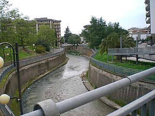
The Tusciano is a river of Campania in southern Italy.
Monte Accellica is a mountain in the Monti Picentini range, located in Campania, Italy. The mountain is 1660 metres tall, and is situated on the border between the provinces of Salerno and Avellino, divided between the comuni of Acerno, Giffoni Valle Piana, and Montella. Several rivers typical of the region have their sources on the slopes of Monte Accellica, including the Picentino, the Tusciano, and the Calore Irpino, which is itself the largest tributary of the Volturno. In the local dialects, the mountain is called Céleca or Acéleca.

The Volcano of Roccamonfina is an extinct volcano in Roccamonfina, Campania, southern Italy. It was active from some 650,000 to 50,000 years ago. It comprises an isolated large cone of some 25 km (16 mi) perimeter between the Monti Aurunci, the plain and valley of the Garigliano, the Monte Massico and the Monti Trebulani. The central caldera has a diameter of nearly 6 km (4 mi) and the small commune (town) of Roccamonfina is located inside it. Volcanic activity is now replaced by minor seismic movements and by the presence of mineral waters. The mount is part of the Roccamonfina-Garigliano Mouth Regional Park, created in 1999.

The Monti Picentini Regional Park is a natural preserve in Campania, southern Italy.

The geology of Croatia has some Precambrian rocks mostly covered by younger sedimentary rocks and deformed or superimposed by tectonic activity.

The geology of Italy includes mountain ranges such as the Alps, the Dolomites and the Apennines formed from the uplift of igneous and primarily marine sedimentary rocks all formed since the Paleozoic. Some active volcanoes are located in Insular Italy.
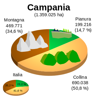
The geography of Campania illustrates the geographical characteristics of Campania, a region of Italy.
