
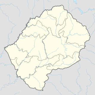
Mafeteng is a district of Lesotho. It has an area of 2,119 km² and a population in 2016 of 178,222. Mafeteng is the capital or camptown, and only town in the district. In the west, Mafeteng borders on the Free State Province of South Africa. Domestically, it borders on the following districts Maseru District in the northeast and Mohale's Hoek District in the southeast.
Maseru is a district of Lesotho. Maseru is also the name of the district's capital, and is the only city in the district and also the capital of the country. It is the largest urban area in the country, and therefore the only city. The city of Maseru is located on Lesotho's western border with the Free State Province of South Africa, the frontier being the Caledon River. Maseru borders on Berea District in north, Thaba-Tseka District in the east, Mohale's Hoek District in south, and Mafeteng District in southwest.

Mohale's Hoek is the capital city of Mohale's Hoek District in Lesotho. It had a population of approximately 40,040 in 2016.
Mohale's Hoek is a district of Lesotho. Mohale's Hoek is the capital city or camptown, and only town in the district. In the southwest, Mohale's Hoek borders on South Africa, while domestically, it borders on Mafeteng District in northwest, Maseru District in north, Thaba-Tseka District in northeast, Qacha's Nek District in east, and Quthing District in southeast.
Lesotho requires its residents to register their motor vehicles and display vehicle registration plates.
'Mamantšo is a community council located in the Mafeteng District of Lesotho. Its population in 2006 was 21,175.
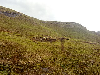
Khoelenya is a community council located in the Mohale's Hoek District of Lesotho. Its population in 2006 was 22,424.
Mashaleng is a community council located in the Mohale's Hoek District of Lesotho. Its population in 2006 was 21,869.
Mootsinyane is a community council located in the Mohale's Hoek District of Lesotho. Its population in 2006 was 9,995.
Nkau is a community council located in the Mohale's Hoek District of Lesotho. Its population in 2006 was 9,092.
Phamong is a community council located in the Mohale's Hoek District of Lesotho. Its population in 2006 was 8,402. Chieftainess Nthati Bereng Bereng was confirmed into office as Principal Chief of Phamong at a ceremony presided over by King Letsie III on August 27, 2004. The inauguration follows the death of her husband in 2002.
Qabane is a community council located in the Mohale's Hoek District of Lesotho. Its population in 2006 was 6,924.
Qhobeng is a community council located in the Mohale's Hoek District of Lesotho. Its population in 2006 was 3,083.
Qobong is a community council located in the Mohale's Hoek District of Lesotho. Its population in 2006 was 9,324.
Siloe is a community council located in the Mohale's Hoek District of Lesotho. Its population in 2006 was 18,261.
Teke is a community council located in the Mohale's Hoek District of Lesotho. Its population in 2006 was 5,403.
Thaba Mokhele is a community council located in the Mohale's Hoek District of Lesotho. Its population in 2006 was 18,135.
Mateanong is a community council located in the Mokhotlong District of Lesotho. Its population in 2006 was 7,387.
Mohale's Hoek Airport is an airport serving the city of Mohale's Hoek, the capital of Mohale's Hoek District, Lesotho.
