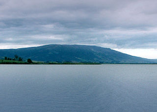
Maungatua, known also as Maukaatua is a prominent ridge in the Taieri Plains in Otago, New Zealand.

The Whanganui National Park is a national park located in the North Island of New Zealand. Established in 1986, it covers an area of 742 km2 bordering the Whanganui River. It incorporates areas of Crown land, former state forest and a number of former reserves. The river itself is not part of the park, but is a popular paddling route titled the Whanganui Journey, one of New Zealand's "Great Walks".

Dacrycarpus dacrydioides, commonly known as kahikatea and white pine, is a coniferous tree endemic to New Zealand. A podocarp, it is New Zealand's tallest tree, gaining heights of 60 m over a life span of 600 years. It was first described botanically by the French botanist Achille Richard in 1832 as Podocarpusdacrydioides, and was given its current binomial name Dacrycarpus dacrydioides in 1969 by the American botanist David de Laubenfels. Analysis of DNA has confirmed its evolutionary relationship with other species in the genera Dacrycarpus and Dacrydium.

Zealandia, formerly known as the Karori Wildlife Sanctuary, is a protected natural area in Wellington, New Zealand, the first urban completely fenced ecosanctuary, where the biodiversity of 225 ha of forest is being restored. The sanctuary was previously part of the water catchment area for Wellington, between Wrights Hill and the Brooklyn wind turbine on Polhill.

Lake Wilkie is a small, scenic lake near Tautuku Bay in the Catlins, south of Dunedin, New Zealand. It formed after the last ice age and has gradually shrunk to its current size of 1.7 hectares (4.2 acres). Bog lakes like Lake Wilkie are a rare ecosystem in this part of the country.

Ōtari-Wilton's Bush is a native botanic garden and forest reserve located in Wilton in Wellington, New Zealand. It is New Zealand's only public botanic garden dedicated solely to the native plants of New Zealand.

Delhi Ridge, sometimes simply called The Ridge, is a ridge in the Northern Aravalli leopard wildlife corridor in the National Capital Territory of Delhi in India. It is a northern extension of the ancient Aravalli Range, some 1.5 billion years old. The ridge consists of quartzite rocks and extends from the southeast at Tughlaqabad, near the Bhatti mines, branching out in places and tapering off in the north near Wazirabad on the west bank of the river Yamuna, covering about 35 kilometres.

Mapungubwe National Park is a national park in the Limpopo Province, South Africa. The park protects the historical site of Mapungubwe Hill, which was the capital of the Kingdom of Mapungubwe, as well as the wildlife and riverine forests along the Limpopo River. The Mapungubwe Hill was the site of a community dating back to the Iron Age. Evidence has shown that it was a prosperous community. Archaeologists also uncovered the famous Golden Rhinoceros of Mapungubwe figurine from the site.
Thursley Common is a national nature reserve in Surrey, England, and has also been designated as a Ramsar wetland. It is also part of a Site of Special Scientific Interest called Thursley, Hankley and Frensham Commons.

The Town Belt is a green belt which surrounds the centre of the New Zealand city of Dunedin. Covering a total of over 200 hectares, it extends around three sides of the city's centre at a distance from it of some 1-3 km in a broad 7 km crescent from the Oval at Kensington in the south through the suburbs of Mornington, City Rise, Belleknowes, Roslyn, Maori Hill, Prospect Park, Glenleith, Woodhaugh, The Gardens and Dunedin North and the slopes of Signal Hill. The fourth side of the central city is bounded by the Otago Harbour.

Mkhambathi Nature Reserve is a protected area at Lusikisiki in the Eastern Cape, South Africa. It is 7,720 hectares, with the Pondoland Marine Protected Area off its coastal edge. The reserve is located in the Pondoland Centre of Plant Endemism and the greater Maputaland–Pondoland–Albany Hotspot, and is covered in open grassland, dotted with patches of indigenous forest, swamp forests and flanked by the forested ravines of the Msikaba and Mtentu rivers.

Helderberg Nature Reserve is a 398-hectare (980-acre) nature reserve in Somerset West, South Africa.
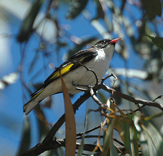
The Clarkesdale Bird Sanctuary is a nature reserve focused on protecting and restoring habitat for woodland birds. It lies in the state of Victoria in south-eastern Australia, near the small town of Linton, 30 km south-west of the city of Ballarat.

Pāuatahanui Wildlife Reserve is a wetland reserve at the eastern edge of the Pāuatahanui Inlet of the Porirua Harbour in Porirua, New Zealand. The reserve contains the most significant area of saltmarsh in the lower North Island of New Zealand. It also includes tidal mudflats, shrub lands and regenerating coastal forest. The reserve covers 50 hectares, of which the Department of Conservation owns 46 hectares, and Forest & Bird owns the remaining 4 hectares under covenant to the Queen Elizabeth II Trust. The reserve is managed by a committee of Forest & Bird representatives in association with the Department of Conservation.
Long Forest Nature Conservation Reserve is a 600-hectare (1,500-acre) protected area in the Australian state of Victoria situated 50 kilometres (31 mi) to the west of the state capital of Melbourne, between Melton and Bacchus Marsh. It is managed by Parks Victoria.
Trotters Gorge is a locality in the Otago region, in the South Island of New Zealand. It is located 12 kilometres to the north of Palmerston, inland from State Highway 1. The gorge and the creek which runs through it were named for the family of early settler W. S. Trotter.

Pirongia Forest Park is a protected area 30 km southwest of Hamilton, New Zealand. It covers 167.7 square kilometres (64.7 sq mi) across four blocks of land - Pirongia, Te Maunga O Karioi Block, and the small Mangakino Block and Te Rauamoa Block. The park encompasses Mount Pirongia west of Pirongia and Mount Karioi near the coast southwest of Raglan.
Wairēinga / Bridal Veil Falls Scenic Reserve is also in the area, but is separate to Pirongia Forest Park.

The 950 hectares Chirinda Forest Botanical Reserve is situated on the slopes of Mount Selinda, 30 km south of Chipinge, in the Chipinge Highlands of Manicaland, Zimbabwe, and is administered by the Forestry Commission. The reserve is situated at between 900 and 1,200 m in altitude, and receives some 1,370 mm (54 in) to 1,466 mm (57.7 in) of annual rainfall. 606 hectares of its higher levels, above 1,076 m (3,530 ft), is covered by moist evergreen forest, specifically Zanzibar-Inhambane transitional rain forest, of which it represents the southernmost occurrence. The headwaters of three streams, namely the Zona, Chinyika and Musangazi, drain the two broad highlands which it encloses. The boundaries of the reserve are not strictly enforced, so that cattle grazing and plant harvesting are ongoing. The reserve is surrounded by communal settlements, commercial timber plantations and small-scale commercial farming units. The naturalist Charles Swynnerton was appointed manager of the nearby Gungunyana farm in 1900, and a number of plant, bird and insect names commemorate his collecting activities of the next two decades. Chirinda means "lookout" or "vantage point" in the chiNdau language, or perhaps "place of refuge".

St Johns Bush is a reserve in central Auckland in New Zealand. It is situated in a small valley near the larger Kepa Bush Reserve. It is named after the nearby suburb St Johns.
The Dadia Forest is a large area of natural woodland in the Evros regional unit in northeastern Greece. The forest consists mostly of oak and pine. It is one of the most important areas in Europe for birds of prey, and the only forest in Europe where all four European species of vulture can be seen. It is a fully managed protected area of 7,290 hectares and is visited by about 35,000 people each year.
