
Table Mountain is a flat-topped mountain forming a prominent landmark overlooking the city of Cape Town in South Africa. It is a significant tourist attraction, with many visitors using the cableway or hiking to the top. Table Mountain National Park is the most visited national park in South Africa, attracting 4.2 million people every year for various activities. The mountain has 8,200 plant species, of which around 80% are fynbos, meaning fine bush. It forms part of the Table Mountain National Park, and part of the lands formerly ranged by Khoe-speaking clans, such as the !Uriǁʼaes. It is home to a large array of mostly endemic fauna and flora.

Kruger National Park is a South African National Park and one of the largest game reserves in Africa. It covers an area of 19,623 km2 (7,576 sq mi) in the provinces of Limpopo and Mpumalanga in northeastern South Africa, and extends 360 km (220 mi) from north to south and 65 km (40 mi) from east to west. The administrative headquarters are in Skukuza. Areas of the park were first protected by the government of the South African Republic in 1898, and it became South Africa's first national park in 1926.

Great Limpopo Transfrontier Park is a 35,000 km² peace park that is in the process of being formed. It will link the Limpopo National Park in Mozambique, Kruger National Park in South Africa, Gonarezhou National Park, Manjinji Pan Sanctuary and Malipati Safari Area in Zimbabwe, as well as the area between Kruger and Gonarezhou, the Sengwe communal land in Zimbabwe and the Makuleke region in South Africa.
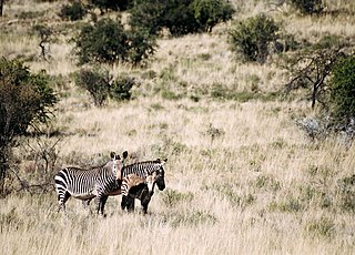
Mountain Zebra National Park is a national park in the Eastern Cape province of South Africa; proclaimed in July 1937 for the purpose of providing a nature reserve for the endangered Cape mountain zebra. It is surrounded by 896,146.57 hectares of the Mountain Zebra-Camdeboo Protected Environment.
Giyani is a town situated in the north-eastern part of Limpopo Province, South Africa. It is the administrative capital of the Mopani District Municipality and a former capital of the defunct Gazankulu Bantustan. The town of Giyani has seven sections: Section A, Section D1, Section D2, Section E, Section F, Kremetart, and Giyani CBD. Risinga View and Church View are new residential areas in Giyani,but they fall under the local traditional leaders. The Giyani CBD is nicknamed Benstore, and this name is commonly used by residents of the region. Giyani is surrounded by a number of villages with rich Tsonga cultural activities, administered by the Greater Giyani Local Municipality.

Tankwa Karoo National Park is a national park in South Africa. The park lies about 70 km due west of Sutherland near the border of the Northern Cape and Western Cape, in one of the most arid regions of South Africa, with areas receiving less than 100 mm of average annual precipitation, moisture-bearing clouds from the Atlantic Ocean being largely stopped by the Cederberg mountains. Other low areas receive little more, as the Roodewerf station with 180 mm of mean annual rainfall. In the hottest areas of the park, the mean maximum temperature in January is 38.9 °C, and in July the mean minimum temperature ranges from about 5 to 7 °C. Before this Park's proclamation, the only protected area of Succulent Karoo was the 2 square kilometre patch of the Gamkaberg Nature Reserve. Succulent Karoo has, together with the Cape Floral Kingdom, been declared a Biodiversity Hotspot by Conservation International.
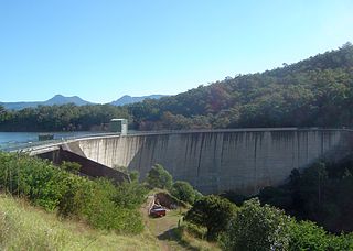
The Moogerah Dam is a mass concrete double curvature arch dam with an un-gated spillway across Reynolds Creek in South East Queensland, Australia, now within the locality of Moogerah in the Scenic Rim Region. The main purposes of the dam are for irrigation in the Reynolds Creek district and for supply of potable water to Warrill Creek and farmers in the Warrill Valley. The impounded reservoir is called Lake Moogerah.

Bontebok National Park is a species-specific national park in South Africa. It was established in 1931 to ensure the preservation of the Bontebok. It is the smallest of South Africa's 18 National Parks, covering an area of 27.86 km2 The park is part of the Cape Floristic Region, which is a World Heritage Site.

Skukuza, a town in Mpumalanga located 57 km east of Hazyview at the confluence of the N'waswitshaka and Sabie Rivers, is the administrative headquarters of the Kruger National Park.
Marakele National Park is a National Park, part of the Waterberg Biosphere in Limpopo Province, South Africa.
Malamulele can refer to the town of Malamulele or the area of Malamulele. Both the town and area are in the Limpopo province of South Africa and predominantly occupied by Tsonga people. Malamulele town has one provincial road and one regional road; the R81 to Giyani and the R524 to Thohoyandou respectively. Malamulele is flanked by two rivers, Levubu River (Rivhubye) to the west and Letaba River to the east, meanwhile the Shingwedzi River runs from Malamulele West to Malamulele East, joining the Olifants in Mozambique on its way to the Indian Ocean. Malamulele is the seat of the Collins Chabane Local Municipality.
The Kruger National Park is a South African National Park and one of the largest game reserves in Africa. Originally known as The Sabi Game Reserve, it became a game reserve in 1898. The park became known as Kruger National Park in 1926, when it was named after Paul Kruger.

Shingwedzi is a rest camp and ranger's post situated in the northern section of the Kruger National Park. The camp is located on the southern bank of the Shingwedzi River, for which it is named, in Limpopo province, South Africa. The surrounding country formerly constituted the Singwitsi Reserve, proclaimed in 1903, which encompassed over 5,000 square kilometers. The region was over-hunted by the end of the 19th century, its big game depleted and its elephant population completely decimated. The name "Shingwedzi" is of Tsonga origin, and was perhaps derived from "Shing-xa-goli", perhaps a local chieftain, and "njwetse", the sound of iron rubbing against iron.

Lower Sabie is one of Kruger National Park's Main rest camps and is situated on the southern bank of the Sabie River, in the southeastern section of the park. It is connected to the main Skukuza camp by the H4-1 tarred road, which is often considered to be the busiest road in the park.

Skukuza Airport is the only commercial airport in Kruger National Park, located near Skukuza, in the Mpumalanga province in South Africa. The airport was established in 1958 and was named in honour of James Stevenson-Hamilton, the first warden of the Kruger national park. In 2018, the airport was dubbed "the prettiest airport in the world" by Forbes.

Zandspruit Bush & Aero Estate is a 1 000 ha secure living wildlife estate situated 2 kilometres (1.2 mi) from the town of Hoedspruit, 30 kilometres (19 mi) from the Blyde River Canyon, and 70 kilometres (43 mi) from the Kruger National Park, in the Limpopo Province of South Africa. It is the first development in the world to combine a residential airpark with a game reserve.

Kgaswane Mountain Reserve is a nature reserve of 5,300 hectares consisting of veld and mountains run by the North West Parks and Tourism Board. It is located 5 km (3.1 mi) south-west of Rustenburg on the northern slopes of the Magaliesberg, inside of the Magaliesberg Biosphere Reserve and alongside the western portion of the Magaliesberg Protected Natural Environment. Kgaswane is home to many species of flora and bird life and large and small mammals, and has been designated as a protected Ramsar site since 2019. The reserve has a number of camp sites, hikes and trails.
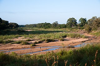
The N'waswitshaka River and its tributaries are completely contained in the southern Kruger Park, Mpumalanga, South Africa. It has its origin near Pretoriuskop and joins the Sabie River at Skukuza. The name means "the happy one" in Xitsonga, and is said to relate to an individual who always smiled.

Crocodile Bridge is the name of both a camp along the southern border of Kruger National Park and a gate to the park in Mpumalanga Province of South Africa. The gate is at a low water bridge crossing the Crocodile River and leads directly to the Crocodile Bridge rest camp. The park entry, including payment, is adjacent to the camp itself.

Letaba is a main rest camp along the Letaba River in the north-central region of Kruger National Park in South Africa. It is situated at the junction of the H1-5 and the H9 road westward to Phalaborwa gate. The name comes from the Sesotho word for "river of sand", because of the wide, generally shallow river.
