Related Research Articles

The University of Queensland is a public research university located primarily in Brisbane, the capital city of the Australian state of Queensland. Founded in 1909 by the Queensland parliament, UQ is one of the six sandstone universities, an informal designation of the oldest university in each state. UQ is also a founding member of edX, Australia's leading Group of Eight and the international research-intensive Association of Pacific Rim Universities.
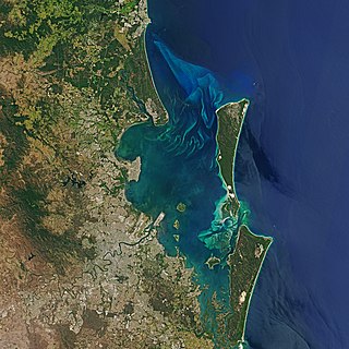
Moreton Bay is a bay located on the eastern coast of Australia 14 kilometres (8.7 mi) from central Brisbane, Queensland. It is one of Queensland's most important coastal resources. The waters of Moreton Bay are a popular destination for recreational anglers and are used by commercial operators who provide seafood to market.

Stradbroke Island, also known as Minjerribah, was a large sand island that formed much of the eastern side of Moreton Bay near Brisbane, Queensland until the late 19th century. Today the island is split into two islands: North Stradbroke Island and South Stradbroke Island, separated by the Jumpinpin Channel.

North Stradbroke Island, colloquially Straddie or North Straddie, is an island that lies within Moreton Bay in the Australian state of Queensland, 30 kilometres (19 mi) southeast of the centre of Brisbane. Originally there was only one Stradbroke Island but in 1896 it split into North Stradbroke Island and South Stradbroke Island separated by the Jumpinpin Channel. The Quandamooka people are the traditional owners of North Stradbroke island.
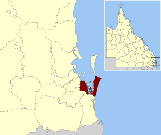
Redland City, better known as the Redlands and formerly known as Redland Shire, is a local government area and a part of the Brisbane metropolitan area in South East Queensland, Australia. With a population of 159,222 in June 2021, the city is spread along the southern coast of Moreton Bay, covering 537.2 square kilometres (207.4 sq mi). Its mainland borders the City of Brisbane to the west and north-west, and Logan City to the south-west and south, while its islands are situated north of the City of Gold Coast.
Moreton Bay is a locality split between the City of Brisbane and the City of Redland, both in Queensland, Australia. The locality includes all of the bay Moreton Bay between the mainland of the City of Brisbane and the City of Redland across to the western coast of Moreton Island and the western coast of North Stradbroke Island. In the 2021 census, Moreton Bay had a population of 0 people.

Peel Island is a small heritage-listed island located in Moreton Bay, east of Brisbane, in South East Queensland, Australia. The island is a locality within the local government area of Redland City and a national park named Teerk Roo Ra National Park and Conservation Park.

Cleveland is a coastal and central locality in the City of Redland, Queensland, Australia. In the 2016 census, Cleveland had a population of 14,801 people.
The Jumpinpin channel also known as The Pin lies between North Stradbroke Island and South Stradbroke Island. It has a fast moving tidal deep water channel not appropriate for swimming but is popular with beach anglers.

Dunwich is a town and locality on the western side of North Stradbroke Island in Queensland, Australia. Dunwich is part of the Redland City local government area, administered from the bayside town of Cleveland on the Queensland mainland. In the 2016 census, Dunwich had a population of 864 people.
Amity is a rural town and locality in the City of Redland, Queensland, Australia. In the 2016 census, the locality of Amity had a population of 387 people.

South Passage is channel between the South Pacific Ocean and Moreton Bay. The other entrances to the bay are the North Passage or North Entrance and Jumpinpin Channel in the south.

Dunwich Cemetery is a heritage-listed cemetery at Bingle Road, Dunwich, North Stradbroke Island in the City of Redland, Queensland, Australia. It was built from 1847 to 1952. It is also known as One Mile Cemetery. It was added to the Queensland Heritage Register on 21 October 1992.

Dunwich Convict Causeway is a heritage-listed causeway at Junner Street, Dunwich, North Stradbroke Island in the City of Redland, Queensland, Australia. It was built in 1827 by convict labour for the Moreton Bay penal settlement. It was added to the Queensland Heritage Register on 22 October 1999.

The Dunwich Benevolent Asylum was a Benevolent Asylum for the aged, infirm and destitute operated by the Queensland Government in Australia. It was located at Dunwich on North Stradbroke Island in Moreton Bay and operated from 1865 to 1946.

Dunwich Public Reserve is a heritage-listed archaeological site at Junner Street, Dunwich, North Stradbroke Island in the City of Redland, Queensland, Australia. It was built from 1827 to 1828. It is also known as Privy Pit, Convict Barracks, and Convict Store within the Moreton Bay penal settlement. It was added to the Queensland Heritage Register on 25 February 2000.
Kooringal is a coastal town and locality on the south-west coast of Moreton Island within the City of Brisbane, Queensland, Australia. In the 2016 census the locality of Kooringal had a population of 45 people.

Heron Island Research Station is a marine research station located on Heron Island, an island within the Great Barrier Reef Marine Park, 80 km from Gladstone, off the coast of Queensland, Australia. It is located at the leeward end of a coral cay on a 10 x 5 kilometre platform reef. Although the island had been used as a turtle cannery in the 1920s, after this was abandoned, it was taken over as a resort in the 1930s, by Captain Christian Poulsen. A number of researchers travelled to the island from the 1930s using the resort facilities. The island became a National Park in 1943, and following the end of World War II, saw the first groups of university students from the University of Queensland arrive. Today the island is divided into three sections - the resort, research station and National Park.
The Nunukul, also spelt Noonuccal and known also as Moondjan are an Aboriginal Australian people, one of three Quandamooka peoples, who traditionally lived on Minjerribah, in Moreton Bay Area and in mainland Brisbane regions.
Paul Tripcony (1901–1975) was an Indigenous Australian and a collector of rare books and Aboriginal stone artefacts from Minjerribah, also known as Stradbroke Island.
References
- ↑ "EXPERIMENTS BY C.S.I.R.O. - ON FISH FARMING AT MORETON ISLAND - Cairns Post (Qld. : 1909 - 1954) - 12 Dec 1951". Trove. Retrieved 2017-04-21.
- ↑ "A Scientist Goes Fishing For The Answers - Why don't we cultivate oysters more? Why are mullet so scarce sometimes? - Brisbane Telegraph (Qld. : 1948 - 1954) - 15 Aug 1950". Trove. Retrieved 2017-04-21.
- 1 2 3 4 "History and Community Life - Moreton Bay Research Station - The University of Queensland, Australia". www.uq.edu.au. Retrieved 2017-04-21.
- ↑ "About Us - Moreton Bay Research Station - The University of Queensland, Australia". www.uq.edu.au. Retrieved 2017-04-21.
- ↑ "Moreton Bay Research Station". Radio National. 2000-06-27. Retrieved 2017-04-21.
- ↑ West, Wells, John (1955-01-01). "Recent and subfossil corals of Moreton Bay, Queensland". 4.
{{cite journal}}: Cite journal requires|journal=(help)CS1 maint: multiple names: authors list (link) - ↑ "Moreton Bay Research Station opens to public". UQ News. Retrieved 2017-04-21.