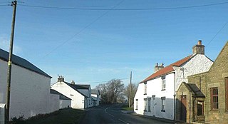
Aislaby is a small village and civil parish on the north bank of the River Tees within the borough of Stockton-on-Tees and the ceremonial county of County Durham, England. It is located to the west of Eaglescliffe and Yarm. The name, first attested as Asulue(s)bi in 1086, is of Viking origin and means "Aslak's farm." Aislaby was listed in the Domesday Book of 1086.

Killerby is a village in the borough of Darlington and the ceremonial county of County Durham, England. It is situated a few miles to the west of Darlington. Details are maintained in the parish of Staindrop.

Waskerley is a village in County Durham, England. It is situated six miles to the southwest of Consett and three miles southwest of Castleside and the A68. Stanhope in the Durham Dales is a further six miles to the southwest and the Derwent Reservoir and the village of Edmundbyers is approximately five miles to the north. The village of Muggleswick is three miles to the north.

Bournmoor is a village in County Durham, England, and is situated a short distance from Chester-le-Street.
Kinninvie is a hamlet in County Durham, England. It is situated to the north of Barnard Castle. Kinninvie is in the civil parish of Marwood.

Moor End is a place in County Durham, England. It is situated immediately to the east of Durham, close to Gilesgate Moor and Carrville. It is situated within the parish of Belmont and as Belmont and Carrville have expanded is now largely indistinct from its neighbours.

Hamsterley is a village in County Durham, England. It is situated to the north of Consett and borders the hamlet of Low Westwood.

Haswell Moor is a small village in County Durham, England. It is situated between Haswell and Shotton Colliery.

Haswell Plough is a village in County Durham, England. It is situated between Durham and Peterlee, south of Haswell. Haswell Plough was first mentioned in the 12th century as being one of three parts of the village of Haswell. It is also the village where MEP of thirty years Stephen Hughes was brought up.

Healeyfield is a village and civil parish in County Durham, England. The population of the civil parish taken from the 2011 census was 1,544. It is situated to the south west of Consett.

Foxton is a small village in County Durham, England. It is situated to the north-west of Stockton-on-Tees, near Stillington.

Urra Moor is the highest moor in the North York Moors, North Yorkshire, England. At 1,490 feet (454 m) above sea level it is the highest point in Hambleton District and the North York Moors National Park, and the fourteenth most prominent hill in England. The name is a mix of Old English and Old Norse which means The Dirty Hill. The name of Urra Moor applies to the moor as a whole; the summit itself is known as Round Hill.

The River Hyndburn is a minor river in Lancashire, England. Beginning as Woodnook Water on the slopes of Goodshaw Hill, it passes through Stone Fold, Rising Bridge and Baxenden where it is augmented by streams from Thirteen Stone Hill and continues to the Woodnook area of Accrington. Near St James Church, it collects Broad Oak Water, becoming the River Hyndburn. It heads northward through the town centre, collecting Pleck Brook and turning west, flowing under the East Lancashire railway line viaduct and continuing to Church.

Morley is a village and civil parish within the Borough of Erewash in Derbyshire, England.
Morley Saint Botolph is a village and former civil parish, now in the parish of Morley, in the South Norfolk district, in the county of Norfolk, England. It is situated 4 km south-west of the town of Wymondham and 23 km south-west of the city of Norwich. The village name is normally abbreviated to "Morley St Botolph". In 1931 the parish had a population of 204.

Stainmore is a remote geographic area in the Pennines on the border of Cumbria, County Durham and North Yorkshire. The name is used for a civil parish in the Eden District of Cumbria, England, including the villages of North Stainmore and South Stainmore. The parish had a population of 253 in the 2001 census, increasing to 264 at the Census 2011. Stainmore Forest stretches further east into County Durham, towards Bowes.
Morley is a civil parish in the South Norfolk district, in the county of Norfolk, England. It includes the villages of Morley St Botolph and Morley St Peter. It covers an area of 8.21 km2 (3.17 sq mi) and had a population of 973 in 182 households at the 2001 census, increasing to a population of 1.241 in 191 households at the 2011 census.

Warmfield cum Heath is a civil parish in the City of Wakefield in West Yorkshire, England. The parish lies just over 1-mile (1.6 km) east of Wakefield, and has 57 listed buildings within the parish boundaries.

