
Mornington Crescent is a London Underground station in Somers Town in north west London, named after the nearby street. The station is on the Charing Cross branch of the Northern line, between Camden Town and Euston stations. It is in Travelcard Zone 2.

Mornington Crescent is a terraced street in Camden Town, Camden, London, England. It was built in the 1820s, on a greenfield site just to the north of central London. Many of the houses were subdivided into flats during the Victorian era, and what was the street's communal garden is now the Carreras Building. Mornington Crescent tube station which opened in 1907, takes its name from the street.
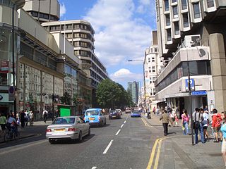
The A400 road is an A road in London that runs from Charing Cross to Archway in North London. It passes some of London's most famous landmarks.
This is a list of the etymology of street names in the area of Regent's Park in London ; the area has no formal boundaries, though it generally thought to be delimited by Prince Albert Road to the north, Park Village East and Hampstead Road/the Euston railway line/Eversholt Street to the east, Euston Road and Marylebone Road to the south and Park Road and Baker Street to the west.

Chalton Street is a street in the Somers Town neighbourhood of London, England. Chalton Street is over a kilometre long and stretches from Euston Road to almost Camden Town, before taking a hard right turn and terminating at St Pancras Hospital.

Harrington Square is a garden square in the Camden Town area of London, England. It is located at the northern end of Hampstead Road and next to Mornington Crescent tube station.
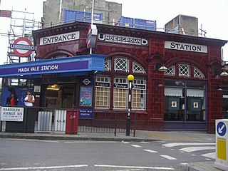
Randolph Avenue is a street in Maida Vale in London. Located in the City of Westminster, it is a long avenue running from north to south. The southern end is located in Little Venice near to the Paddington branch of the Grand Union Canal. The street runs northwards, crossing Clifton Gardens, Sutherland Avenue, Elgin Avenue and Carlton Vale. The road then continues as Randolph Gardens until it meets Kilburn Park Road. The Edgware Road runs directly parallel to Randolph Avenue to the east.

Gloucester Avenue is a street in the Primrose Hill area of London, England. Located in the London Borough of Camden, it is a residential road featuring many nineteenth century properties including several pubs as well as the neo-Georgian Cecil Sharp House. For much of its route it runs adjacent to the West Coast Main Line out of Euston Station.

Arlington Road is a street running between Mornington Crescent and Camden Town in the London Borough of Camden, England. It runs south to north, directly parallel to Camden High Street to its east. It is crossed by Inverness Street, Parkway and Delancey Street. It is near Gloucester Crescent. It is mainly residential, with a few commercial properties.

Norfolk Square is a rectangular garden square in Paddington in Central London. Located in the City of Westminster, it is part of the Tyburnia district north of Hyde Park. It runs east to west from London Street to Norfolk Place. Praed Street and Sussex Gardens are directly parallel to it north and south respectively.

Oakley Square is a crescent-shaped garden square in Somers Town in Central London, close to Mornington Crescent and Camden Town. It is located in the London Borough of Camden and runs roughly northeastwards from Eversholt Street meeting with the southern end of Camden Street on its eastern side.
Well Walk is a street in Hampstead, England in the London Borough of Camden. It runs southwestwards from Hampstead Heath to Flask Walk which then continues on towards the centre of Hampstead Village around the Hampstead tube station. It takes its name from the historic Hampstead Wells.

Flask Walk is a street in Hampstead in the London Borough of Camden. It runs eastwards from Hampstead High Street to a junction with Well Walk and New End Square. It is primarily residential but the western end of the street is a pedestrianised alley featuring commercial properties. Hampstead tube station is located close to the junction with the High Street.

Maresfield Gardens is a street in Hampstead. Located in the London Borough of Camden, it runs parallel to the west of Fitzjohns Avenue for much of its route before curving to join it at is southern end. It crosses Nutley Terrace and Netherhall Gardens. The Belsize Tunnel passes underneath the street. It primarily feature red brick buildings.

Branch Hill is a street in Hampstead. Located in the London Borough of Camden it is named after a hill on Hampstead Heath and runs adjacent to the heath between Frognal Rise and West Heath Road. Branch Hill, then largely open countryside, was a favourite landscape of the artist John Constable and he painted it on a number of occasions. Branch Hill Pond is located close to the junction with West Heath Road, while it dried up in the early twentieth century recent efforts have been made to restore it.

Fitzroy Road is a street in the Primrose Hill area of London. Located in the London Borough of Camden, it is a residential road lined with Victorian era houses. It runs roughly northeastwards from Regent's Park Road at the edge of Primrose Hill to Gloucester Avenue. Fitzroy Road is crossed around halfway along its route by Chalcot Road that links it to Chalcot Square to the north. The Princess of Wales pub stands at the corner with Chalcot Road.

Delancey Street is a mainly residential street in Camden Town, London, England. Located in the London Borough of Camden, it runs roughly west to east in a curve from Camden High Street to Parkway. It is met or crossed by Arlington Road, Albert Street, Gloucester Avenue, and Mornington Terrace. Eastwards of Camden High Street the route continues as Pratt Street as far as the Regent's Canal.

The Edinboro Castle is a Grade II listed public house on Mornington Terrace in the London Borough of Camden. It was constructed in 1839 and was named after Edinburgh Castle in Scotland, with the original spelling of the pub being the same. It once housed a small museum, art gallery and tea gardens. It was listed in 1973. In 1984 a fire damaged the pub but it was refurbished in its original Victorian style by Charringtons.

Oval Road is a street in the Camden Town area of London. It runs northwards from Gloucester Avenue near Parkway to the Regent's Canal, a little to the west of the centre of Camden Town. Close to its southern end is the junction with Delancey Street. It then heads northwards as Gloucester Crescent curves away and then rejoins the street while Regent's Park Terrace follows more closely beside Oval Road.
Pond Square is a garden square and village green in Highgate, London. Located close to Highgate High Street and The Gatehouse it is today in the London Borough of Camden. Swain's Lane runs off the square heading downhill past Highgate Cemetery.

