
South San Francisco is a city in San Mateo County, California, United States, on the San Francisco Peninsula in the San Francisco Bay Area. Its location has been populated for more than 5,000 years. The city is colloquially termed "South City". The population was 66,105 at the 2020 census.
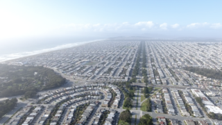
The Sunset District is a neighborhood located in the southwest quadrant of San Francisco, California, United States.
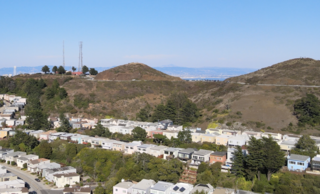
The Twin Peaks are two prominent hills with an elevation of about 925 feet (282 m) located near the geographic center of San Francisco, California. The Twin Peaks are the second and third highest natural points in San Francisco; only 928 foot (283 m) Mount Davidson is higher within city limits.

The San Francisco Public Library is the public library system of the city and county of San Francisco. The Main Library is located at Civic Center, at 100 Larkin Street. The library system has won several awards, such as Library Journal's Library of the Year award in 2018. The library is well-funded due to the city's dedicated Library Preservation Fund that was established by a 1994 ballot measure. The Preservation Fund was renewed twice, by ballot measures in 2007 and 2022.

The Trocadero is a historic building located in San Francisco. Formally it was a lively roadhouse at the turn of the 20th century it had offered gambling at roulette tables and dancing, as well as the best trout pond in California.

Diamond Heights is a neighborhood in central San Francisco, California, roughly bordered by Diamond Heights Boulevard and Noe Valley to the north and east and Glen Canyon Park to the south and west. It is built on three hills: Red Rock Heights on the northwest, Gold Mine Hill in center, and Fairmount Heights on the southeast.

Oaks Park, formally known as the Oakland Baseball Park, and at times nicknamed Emeryville Park, was a baseball stadium in Emeryville, California. It was primarily used for baseball, and was the home field of the Oakland Oaks baseball team in the Pacific Coast League (PCL). It opened in 1913, and held 11,000 people. The Oaks played there until 1955.

Aquatic Park is a public park in Berkeley, California, United States, located just east of the Eastshore Freeway between Ashby and University Avenues. The Works Progress Administration created the park in the 1930s simultaneously with the nearby Berkeley Yacht Harbor. Its centerpiece is an artificial mile-long lagoon that was cut off from San Francisco Bay by the creation of a causeway for the Eastshore Highway, during the construction of the approaches to the San Francisco–Oakland Bay Bridge, also in the 1930s. The lagoon still communicates with the Bay through culverts under the freeway. The east shoreline of the lagoon used to be the original shoreline of San Francisco Bay.

Moore Dry Dock Company was a ship repair and shipbuilding company in Oakland, California. In 1905, Robert S. Moore, his brother Joseph A. Moore, and John Thomas Scott purchased the National Iron Works located in the Hunter's Point section of San Francisco, and founded a new company, the Moore & Scott Iron Works Moore had previously been vice president of the Risdon Iron Works of San Francisco. Scott was nephew to Henry T. and Irving M. Scott, owners of the nearby Union Iron Works, where John had risen from apprentice to superintendent. Their new business was soon destroyed by fire resulting from the San Francisco earthquake.
McLaughlin Eastshore State Park is a state park and wildlife refuge along the San Francisco Bay shoreline of the East Bay between the cities of Richmond, Albany, Berkeley, Emeryville, and Oakland. It encompasses remnant natural wetlands, restored wetlands, as well as landfill west of the Eastshore Freeway. Its shoreline is 8.5 miles (13.7 km) long, and its total area is 1,854 acres (750 ha), which includes both tidelands and uplands. Originally named just Eastshore State Park, it was renamed in October 2012 to honor the late Save the Bay founder Sylvia McLaughlin, who, along with the late Dwight Steele of Citizens for Eastshore Park, drove the establishment of the park. Prior to 2013, it was jointly managed by the California State Parks and East Bay Regional Park District (EBRPD). The state agency and EBRPD executed a 30-year agreement for EBRPD to manage the park.

The InterContinental San Francisco is a high-rise hotel at 888 Howard Street in the South of Market district of San Francisco, California. The 103.63 m (340 ft) 32-story hotel has 550 hotel rooms, and is operated by the InterContinental Hotels Group. The hotel is next to the Moscone West Center, completed in 2003. The hotel opened on February 28, 2008. There is a two-level underground garage and a six-floor podium housing hotel amenities.
The Parkside is a neighborhood in the western part of San Francisco, California. It is located in the southern part of the Avenues south of Quintara and north of Sloat Boulevard.
Recreation Park was the name applied to several former baseball parks in San Francisco, California in the late 19th century and early 20th century.
Balmy Alley is a one-block-long alley that is home to the most concentrated collection of murals in the city of San Francisco. It is located in the south central portion of the Inner Mission District in Calle 24 between 24th Street and Garfield Square. Since 1973, most buildings on the street have been decorated with a mural.

Greyhound Rock State Marine Conservation Area (SMCA) is one of two adjoining marine protected areas off the coast of San Mateo County and Santa Cruz County, on California's central coast. The area is approximately 55 miles (89 km) south of San Francisco. The SMCA is 11.81 square miles (30.6 km2). Within the SMCA fishing and take of all living marine resources is prohibited except the recreational take of giant kelp, squid, salmon, and other finfish, subject to various conditions. Also permitted is the commercial take of giant kelp, salmon, and squid, subject to various conditions.

The Hayward Area Recreation and Park District (H.A.R.D.) is the park management agency for most of the parks in the city of Hayward, California. It was created in 1944 and is an independent special district under California law. H.A.R.D. is the largest recreation district in California. It also manages parks in the bordering unincorporated communities of Castro Valley, San Lorenzo, Fairview, Ashland and Cherryland. It manages the park grounds for numerous schools in the region. Events and classes are scheduled and listed in a quarterly brochure. The parks' 2021 budget is $24,306,495.
The San Francisco Recreation & Parks Department is the city agency responsible for governing and maintaining all city-owned parks and recreational facilities in San Francisco, as well as Sharp Park Golf Course in Pacifica and Camp Mather in Tuolumne County. Current facilities include 4,113 acres (1,664 ha) of total recreational and open space with 3,400 acres (1,376 ha) of that land within San Francisco. The department runs 179 playgrounds and play areas, 82 recreation centers and clubhouses, nine swimming pools, five golf courses, 151 tennis courts, 72 basketball courts, 59 soccer fields, numerous baseball diamonds, and other sports venues.

Nob Hill is a neighborhood of San Francisco, California, United States that is known for its numerous luxury hotels and historic mansions. Nob Hill has historically served as a center of San Francisco's upper class. Nob Hill is among the highest-income neighborhoods in the United States, as well as one of the most desirable and expensive real estate markets in the country. Prior to Covid-19, it was the most expensive real estate market per metre squared, narrowly beating Monte Carlo, although it has since fallen heavily. It was the only place in the United States so far where market price per square metre exceeded the average yearly salary in the country.

Boeddeker Park, more formally known as Father Alfred E. Boeddeker Park, is an urban park in the Tenderloin neighborhood of San Francisco. This 1-acre park was renovated and reopened in 2014, especially intended to serve the needs of people in the surrounding neighborhood who experience amongst the highest levels of poverty in the city. The park was completed with a large mural, Everyone Deserves a Home, on the building above the park in 2016.

