
Delta County is a county in the Upper Peninsula in the U.S. state of Michigan. As of the 2020 census, the population was 36,903. The county seat is Escanaba. The county was surveyed in 1843 and organized in 1861. Its name originates from the Greek letter delta (Δ), which refers to the triangular shape of the original county which included segments of Menominee, Dickinson, Iron, and Marquette counties. Recreation and forest products are major industries, and crops include hay, corn, small grains, potatoes, and strawberries.

Fairbanks Township is a civil township of Delta County in the U.S. state of Michigan. As of the 2010 census, the township population was 281, down from 321 at the 2000 census.

Cedarville Township is a civil township of Menominee County in the U.S. state of Michigan. The population was 242 as of the 2020 census. The township was established in 1863.

Gourley Township is a civil township of Menominee County in the U.S. state of Michigan. The population was 451 at the 2020 census.
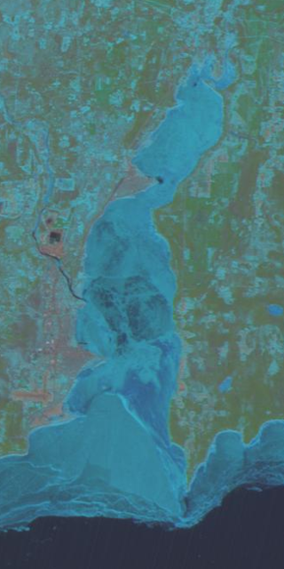
Little Bay de Noc is a bay in the Upper Peninsula of the U.S. state of Michigan. The bay opens into Lake Michigan's Green Bay.

The Cosumnes River is a river in northern California in the United States. It rises on the western slope of the Sierra Nevada and flows approximately 52.5 miles (84.5 km) into the Central Valley, emptying into the Mokelumne River in the Sacramento-San Joaquin Delta.

The Ontonagon River is a river flowing into Lake Superior at the village of Ontonagon, on the western Upper Peninsula of Michigan in the United States. The main stem of the river is 25 miles (40 km) long and is formed by a confluence of several longer branches, portions of which have been collectively designated as a National Wild and Scenic River. Several waterfalls occur on the river including Agate Falls and Bond Falls.
The Rapid River is a 35.9-mile-long (57.8 km) river on the Upper Peninsula of the U.S. state of Michigan. It rises in southeast Marquette County and flows into Little Bay de Noc on Lake Michigan near the community of Rapid River.
The Whitefish River is an 11.9-mile-long (19.2 km) river on the Upper Peninsula of the U.S. state of Michigan. The mouth of the river is in Delta County at 45°54′34″N86°58′01″W on the Little Bay De Noc of Lake Michigan. The main branch of the river is formed by the confluence of the east and west branches at 46°03′25″N86°52′17″W.

St. Martin Island is located off the Garden Peninsula in Delta County in the U.S. state of Michigan. It is the southernmost island in Michigan that is part of a line of islands at the mouth of the bay of Green Bay and is part of the Niagara Escarpment.

Blue Lake is a 31-acre (13 ha) lake with a marshy shoreline that is located in southern Alger County, Michigan in the middle of the Hiawatha National Forest. It is located about a mile north of the intersection of Federal Forest Highway 13 and Delta County Road 440 and just north of the county line with Delta County and just west of the county line with Schoolcraft County. The only lodging on the lake and for several miles are the cabins of the Hiawatha Resort situated near the Midway General Store.
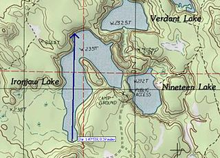
Ironjaw Lake is a 51-acre (21 ha) lake that is located in south-western Schoolcraft County, Michigan in the Hiawatha National Forest. It is just east of the county line with Alger and just north of the county line with Delta County. Other nearby lakes include Hugaboom Lake, Mowe Lake, Blue Lake, Corner-Straits Chain of lakes, Nineteen Lake, Verdant Lake, and Round Lake.

Round Lake is a 475-acre (192 ha) lake that is located mostly in Delta County, Michigan with a little portion in Alger county in the Hiawatha National Forest. Other nearby lakes include Lake Stella, Stoner Lake, West Branch Lake, Hugaboom Lake, Blue Lake, Ironjaw Lake, Ostrander Lake, Corner-Straits Chain and Toms Lake.

Ostrander Lake is a 54.2-acre (21.9 ha) lake that is located near the tri-county corner of Delta County, Michigan, Alger and Schoolcraft countries in the Hiawatha National Forest. The chain consists of Skeels Lake, Corner Lake, Deep Lake, and Straits Lake. Other nearby lakes include Hugaboom Lake, Blue Lake, Ironjaw Lake, the Corner-Straits Chain of lakes, Toms Lake and Round Lake.

The Bedford Shale is a shale geologic formation in the states of Ohio, Michigan, Pennsylvania, Kentucky, West Virginia, and Virginia in the United States.

Sturgeon River may refer to any of the following streams in the U.S. state of Michigan:
Big Bay de Noc is a bay in the Upper Peninsula of the U.S. state of Michigan. The bay, which opens into Lake Michigan's Green Bay, is enclosed by Delta County. The Garden Peninsula is on the east side of the bay and the Stonington Peninsula is on the west side. The small Delta County settlements of Garden and Nahma are harbors on the shore of the bay.
Sturgeon River is a 63.6-mile-long (102.4 km) river in the U.S. state of Michigan, flowing mostly southward through Alger County and Delta County counties on the Upper Peninsula.

Lake Warren was a proglacial lake that formed in the Lake Erie basin around 12,700 years before present (YBP) when Lake Whittlesey dropped in elevation. Lake Warren is divided into three stages: Warren I 690 feet (210 m), Warren II 680 feet (210 m), and Warren III 675 feet (206 m), each defined by the relative elevation above sea level.

Indian Lake is a common name of many waterbodies within the U.S. state of Michigan. According to the Geographic Names Information System (GNIS), there are at least 38 bodies of water in the state that use the Indian Lake name. These bodies of water may include lakes, reservoirs, streams, swamps, or canals with the Indian Lake name or variations.

