
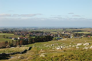
Kleppe is the administrative centre of Klepp municipality in Rogaland county, Norway. The village is located about halfway between the lakes Orrevatnet and Frøylandsvatnet. The village of Bore lies about 3 kilometres (1.9 mi) northwest of Kleppe and the village of Klepp stasjon lies about 3 kilometres (1.9 mi) to the east. The town of Bryne lies about 5 kilometres (3.1 mi) to the south and the city of Sandnes is located about 12 kilometres (7.5 mi) to the northeast. Klepp Church is located in Kleppe.
Undheim is a village in Time municipality in Rogaland county, Norway. The village is located in Jæren, about 14 kilometres (8.7 mi) south of the village of Ålgård, about 12 kilometres (7.5 mi) southeast of the town of Bryne, and about 7 kilometres (4.3 mi) east of the village of Nærbø. The village of Mossige lies just to the northwest of Undheim.
Lyefjell is a village in Time municipality in Rogaland county, Norway. The village is located in the hills about 5 kilometres (3.1 mi) east of the town of Bryne and about 5 kilometres (3.1 mi) north of the villages of Mossige and Undheim.
Grøsfjellvatnet is a lake in the municipalities of Eigersund, Lund, and Sokndal in Rogaland county, Norway. The 3.09-square-kilometre (1.19 sq mi) lake list just north of the lake Eiavatnet, about 4 kilometres (2.5 mi) west of the village of Heskestad in Lund municipality.
Nilsebuvatnet is a lake in the municipalities of Forsand and Hjelmeland in Rogaland county, Norway. The 2.47-square-kilometre (0.95 sq mi) lake lies in the Lyseheiane mountains about 13 kilometres (8.1 mi) north of the village of Lysebotn and about 25 kilometres (16 mi) east of the village of Årdal. The lake is regulated by a small dam on the southwest corner of the lake. The dam provides water for the Lysebotn power station. The lake drains out into the river Storåna which flows westward towards Årdal. The lake is accessible by a small service road from Lysebotn which leads up to the dam.

Oltedalsvatnet is a lake in the municipality of Gjesdal in Rogaland county, Norway. The 3.12-square-kilometre (1.20 sq mi) lake lies just south of the village of Oltedal. It is a reservoir along the river Oltedalsåna that is used to store water for the Oltedal Hydroelectric Power Station. The lake sits at an elevation of 101.5 to 112.5 metres and it holds about 28,800,000 cubic metres.

Tysdalsvatnet or Tyssdalsvatnet is a lake in the municipalities of Hjelmeland and Strand in Rogaland county, Norway. The 3.74-square-kilometre (1.44 sq mi) lake lies about 5 kilometres (3.1 mi) south of the village of Årdal and about 8 kilometres (5.0 mi) east of the village of Tau. The Norwegian National Road 13 (Rv13) runs along the northern side of the lake. The Svo Tunnel was completed in 2013 and it routes much of Rv13 through a mountain rather than along the narrow shoreline of the lake.
Vatsvatnet is a lake in the municipality of Vindafjord in Rogaland county, Norway. The 2.16-square-kilometre (0.83 sq mi) lake lies south of the European route E134 highway and north of the village of Vats. The long, narrow lake is 5.8 kilometres (3.6 mi) long, and has a maximum width of 900 metres (3,000 ft). The primary outflow of the lake is the river Åmselva which flows south into the Vatsfjorden.
Vostervatnet is a lake in the municipality of Strand in Rogaland county, Norway. The 2.62-square-kilometre (1.01 sq mi) lake lies in the northwestern part of Strand, just south of the Fognafjorden. The village of Tau lies about 3.5 kilometres (2.2 mi) southwest of the lake. The main outflow of the lake is the river Fiskåna, which flows north from the northeastern corner of the lake, down the hill to the village of Fiskå on the shore of the fjord.
Ørsdalsvatnet or Ørdalsvatnet is a lake in the municipality of Bjerkreim in Rogaland county, Norway. The 12.22-square-kilometre (4.72 sq mi) lake lies about 2 kilometres (1.2 mi) northeast of the village of Bjerkreim. The lake is rather narrow, but it is 15 kilometres (9.3 mi) long.
Øvre Tysdalsvatnet is a lake in the municipality of Hjelmeland in Rogaland county, Norway. The 9-square-kilometre (3.5 sq mi) lake lies on the east side of the village of Årdal. The 12-kilometre (7.5 mi) long lake is only about 800 metres (0.5 mi) wide and it has a fairly steep shoreline, which results in very little habitation around the lake.
Austrumdalsvatnet is a lake in the municipality of Bjerkreim in Rogaland county, Norway. The 2.81-square-kilometre (1.08 sq mi) lake lies about 2.5 kilometres (1.6 mi) southeast of the lakes Hofreistæ and Byrkjelandsvatnet. The village of Øvrebygd lies about 3 kilometres (1.9 mi) west of the lake.
Byrkjelandsvatnet or Storavatnet is a lake in the municipality of Bjerkreim in Rogaland county, Norway. The 5.17-square-kilometre (2.00 sq mi) lake lies about 2 kilometres (1.2 mi) north of the village of Øvrebygd. The lake flows out through the short river Malmeisåna which flows into the lake Hofreistæ.

Holmavatnet is a lake the Setesdalsheiene mountains of Southern Norway. It is located on the border of the municipalities of Suldal, Vinje, and a small part in Bykle. The southeastern corner of the lake is in Bykle, and it is the northernmost part of all of Aust-Agder county. The lake Skyvatn is located about 5 kilometres (3.1 mi) to the south of the lake.
Holmevatnet or Holmevatn is a lake in the Setesdalsheiene area of Norway. It is located in the mountains on the border of the municipalities of Bykle in Aust-Agder county and Suldal in Rogaland county. The 4.76-square-kilometre (1.84 sq mi) lake lies just west of the lake Store Urevatn and to the northeast of the lake Blåsjø. The nearest villages are Berdalen in Bykle, about 20 kilometres (12 mi) to the east and Suldalsosen, about 30 kilometres (19 mi) to the west. The mountain Kaldafjellet lies about 6 kilometres (3.7 mi) north of the lake.
Frøylandsvatnet is a lake in the municipality of Sandnes in Rogaland county, Norway. The 0.48-square-kilometre (120-acre) lake lies on the south side of the village of Hommersåk, about 10 kilometres (6.2 mi) northeast of the city of Sandnes. The lake empties into a small river that runs out of the north end of the lake. The river runs through Hommersåk into an arm of the Gandsfjorden.

Dirdal is a village in Gjesdal municipality in Rogaland county, Norway. The village is located where the Frafjorden joins the main Høgsfjorden. The village lies at the end of the Dirdalen valley, which stretches to the southeast from Dirdal. The village of Gilja lies about 5 kilometres (3.1 mi) into the valley. The village of Oltedal lies about 8 kilometres (5.0 mi) west of Dirdal. Dirdal Church is located in the village.

Susort is a village in Tysvær municipality in Rogaland county, Norway. The village is located along the eastern shore of the Førlandsfjorden, about 5 kilometres (3.1 mi) south of the village of Tysvær. The European route E39 highway runs just outside the village. The word is an old version of the word svarttrost which means "blackbird".
Skjoldastraumen is a village in Tysvær municipality in Rogaland county, Norway. The village is located along the Skjoldafjorden, about 10 kilometres (6.2 mi) east of the village of Grinde and about 5 kilometres (3.1 mi) northwest of the village of Yrke. The village lies on one of the narrowest parts of the fjord, where there is a set of locks on the fjord to raise and lower boats. The village is the site of the Skjoldastraumen Church.
Tysvær or Tysværvåg is a village in Tysvær municipality in Rogaland county, Norway. The village is located at the end of the small Tysværvågen bay, about 2 kilometres (1.2 mi) off of the European route E39 highway. The nearby village of Susort lies about 8 kilometres (5.0 mi) south of the village of Tysvær, the municipal centre of Aksdal lies about 12 kilometres (7.5 mi) to the north, and the village of Hervik lies about 7 kilometres (4.3 mi) to the east. Tysvær Church is located in the village, serving the southwest portion of the municipality.


