| Undheim | |
|---|---|
| Village | |
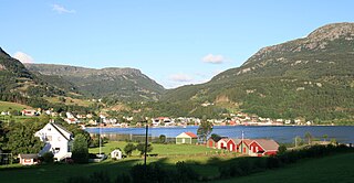
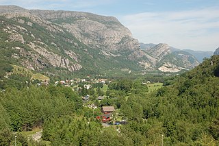
View of the village | |
 Undheim Location in Rogaland county  Undheim Undheim (Norway) | |
| Coordinates: 58°40′56″N05°46′40″E / 58.68222°N 5.77778°E Coordinates: 58°40′56″N05°46′40″E / 58.68222°N 5.77778°E | |
| Country | Norway |
| Region | Western Norway |
| County | Rogaland |
| District | Jæren |
| Municipality | Time |
| Area [1] | |
| • Total | 0.42 km2 (0.16 sq mi) |
| Elevation [2] | 116 m (381 ft) |
| Population (2015) [1] | |
| • Total | 497 |
| • Density | 1,183/km2 (3,060/sq mi) |
| Time zone | CET (UTC+01:00) |
| • Summer (DST) | CEST (UTC+02:00) |
| Post Code | 8680 Trofors |

Undheim is a village in Time municipality in Rogaland county, Norway. The village is located in Jæren, about 14 kilometres (8.7 mi) south of the village of Ålgård, about 12 kilometres (7.5 mi) southeast of the town of Bryne, and about 7 kilometres (4.3 mi) east of the village of Nærbø. The village of Mossige lies just to the northwest of Undheim. [3]

Time is a municipality in Rogaland county, Norway. It is located in the traditional district of Jæren. The administrative centre of the municipality is the town of Bryne. Some villages in the municipality include Kvernaland, Lyefjell, Mossige, and Undheim. Most of Time is fairly flat and it is used for agriculture. The eastern portion of the municipality is more rugged moorland.

Rogaland[²ruːɡɑlɑn](

Norway, officially the Kingdom of Norway, is a Nordic country in Northwestern Europe whose territory comprises the western and northernmost portion of the Scandinavian Peninsula; the remote island of Jan Mayen and the archipelago of Svalbard are also part of the Kingdom of Norway. The Antarctic Peter I Island and the sub-Antarctic Bouvet Island are dependent territories and thus not considered part of the kingdom. Norway also lays claim to a section of Antarctica known as Queen Maud Land.
The 0.42-square-kilometre (100-acre) village has a population (2015) of 497, giving the village a population density of 1,183 inhabitants per square kilometre (3,060/sq mi). [1]

Population density is a measurement of population per unit area or unit volume; it is a quantity of type number density. It is frequently applied to living organisms, and most of the time to humans. It is a key geographical term. In simple terms population density refers to the number of people living in an area per kilometer square.
The main economic activity in and around Undheim is agriculture. It is mainly centered around dairy, beef, pork, and sheep, as well as cultivating fungi and potatoes. The Norwegian poet and writer Arne Garborg (1851-1924) was born on a small farm just outside Undheim. [4] Undheim Church is located in the village. [3]

Agriculture is the science and art of cultivating plants and livestock. Agriculture was the key development in the rise of sedentary human civilization, whereby farming of domesticated species created food surpluses that enabled people to live in cities. The history of agriculture began thousands of years ago. After gathering wild grains beginning at least 105,000 years ago, nascent farmers began to plant them around 11,500 years ago. Pigs, sheep and cattle were domesticated over 10,000 years ago. Plants were independently cultivated in at least 11 regions of the world. Industrial agriculture based on large-scale monoculture in the twentieth century came to dominate agricultural output, though about 2 billion people still depended on subsistence agriculture into the twenty-first.

Arne Garborg, born Aadne Eivindsson Garborg was a Norwegian writer.
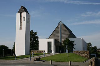
Undheim Church is a parish church in Time municipality in Rogaland county, Norway. It is located in the village of Undheim. The church is part of the Undheim parish in the Jæren deanery in the Diocese of Stavanger. The white, concrete church was built in 2001 by the architecture firm: Link Arkitektur. The church seats about 256 people.