This article does not cite any sources .(March 2010) (Learn how and when to remove this template message) |
| Mount Amida | |
|---|---|
 Mount Amida | |
| Highest point | |
| Elevation | 837 m (2,746 ft) |
| Coordinates | 34°27′01″N132°16′25″E / 34.450387°N 132.273492°E Coordinates: 34°27′01″N132°16′25″E / 34.450387°N 132.273492°E |
| Geography | |
| Location | Hiroshima Prefecture, Japan |
Mount Amida is an 837 metre high mountain in Saeki-ku, Hiroshima, Japan.
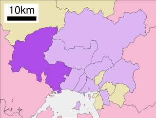
Saeki-ku (佐伯区) is one of the eight wards of the city of Hiroshima, Japan.

Japan is an island country in East Asia. Located in the Pacific Ocean, it lies off the eastern coast of the Asian continent and stretches from the Sea of Okhotsk in the north to the East China Sea and the Philippine Sea in the south.
| This Hiroshima Prefecture location article is a stub. You can help Wikipedia by expanding it. |