
Thurston Island is a largely ice-covered, glacially dissected island, 135 nautical miles long and 55 nautical miles wide, lying between Amundsen Sea and Bellingshausen Sea a short way off the northwest end of Ellsworth Land, Antarctica. The island is separated from the mainland by Peacock Sound, which is occupied by the west portion of Abbot Ice Shelf.
The Amundsen Glacier is a major Antarctic glacier, about 7 to 11 km wide and 150 km (80 nmi) long. It originates on the Antarctic Plateau where it drains the area to the south and west of Nilsen Plateau, then descends through the Queen Maud Mountains to enter the Ross Ice Shelf just west of the MacDonald Nunataks.

The Usarp Mountains are a major mountain range in North Victoria Land, Antarctica. They are west of the Rennick Glacier and trend north to south for about 190 kilometres (118 mi). The mountains are bounded to the north by Pryor Glacier and the Wilson Hills. They are west of the Bowers Mountains.
Borchgrevink Glacier is a large glacier in the Victory Mountains, Victoria Land, Antarctica. It drains south between Malta Plateau and Daniell Peninsula, and thence projects into Glacier Strait, Ross Sea, as a floating glacier tongue.

The Prince Charles Mountains are a major group of mountains in Mac. Robertson Land in Antarctica, including the Athos Range, the Porthos Range, and the Aramis Range. The highest peak is Mount Menzies, with a height of 3,228 m (10,591 ft). Other prominent peaks are Mount Izabelle and Mount Stinear. These mountains, together with other scattered peaks, form an arc about 420 km (260 mi) long, extending from the vicinity of Mount Starlight in the north to Goodspeed Nunataks in the south.

The Quartermain Mountains are a group of exposed mountains in Antarctica, about 20 nautical miles long, typical of ice-free features of the McMurdo Dry Valleys, Victoria Land. They are east of the Lashly Mountains, south of the Asgard Range, west of the Kukri Hills and Royal Society Range, and some distance north of the Worcester Range.
The Betekhtin Range is a mountain range about 14 nautical miles long, forming the southern arm of the Humboldt Mountains in Queen Maud Land, Antarctica.
Explorers Range is a large mountain range in the Bowers Mountains of Victoria Land, Antarctica, extending from Mount Bruce in the north to Carryer Glacier and McLin Glacier in the south.
The Land Glacier is a broad, heavily crevassed glacier, about 35 nautical miles long, descending into Land Bay in Marie Byrd Land, Antarctica. It was discovered by the United States Antarctic Service (1939–41) and named for Rear Admiral Emory S. Land, Chairman of the United States Maritime Commission.
The Worcester Range is a high coastal range, about 30 nautical miles long, in Antarctica. It stands between Skelton Glacier and Mulock Glacier on the western side of the Ross Ice Shelf. It is southwest of the Royal Society Range and north of the Conway Range of the Cook Mountains.
The Emlen Peaks is a group of scattered peaks and nunataks, 16 miles (26 km) long and 7 miles (11 km) wide. It is 6 miles (9.7 km) south of Daniels Range in the south end of the Usarp Mountains in northern Victoria Land, Antarctica.
On the continent of Antarctica, the Aramis Range is the third range south in the Prince Charles Mountains, situated 11 miles southeast of the Porthos Range and extending for about 30 miles in a southwest–northeast direction. It was first visited in January 1957 by Australian National Antarctic Research Expeditions (ANARE) southern party led by W.G. Bewsher, who named it for a character in Alexandre Dumas' novel The Three Musketeers, the most popular book read on the southern journey.
Welch Mountains is a group of mountains that dominate the area, the highest peak rising to 3,015 metres (9,892 ft), located 25 nautical miles north of Mount Jackson on the east margin of the Dyer Plateau of Palmer Land, Antarctica
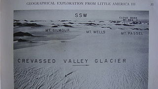
The Denfeld Mountains are a group of scattered mountains between Crevasse Valley Glacier and Arthur Glacier in the Ford Ranges of Marie Byrd Land, Antarctica.
Mount Kropotkin is a peak on the west side of Jøkulkyrkja Mountain in the Mühlig-Hofmann Mountains of Queen Maud Land, Antarctica. It was mapped by the Norsk Polarinstitutt from surveys and air photos by the Sixth Norwegian Antarctic Expedition, 1956–60. The peak was also mapped by the Soviet Antarctic Expedition in 1961 and named for Russian anarchist Peter Kropotkin.
Paradise Harbour is a wide embayment behind Lemaire Island and Bryde Island, indenting the west coast of Graham Land, Antarctica, between Duthiers Point and Leniz Point. The name was first applied by whalers operating in the vicinity and was in use by 1920.
Mount Elizabeth is a massive ice-free mountain, 4,480 metres (14,700 ft) high, standing 6 nautical miles south of Mount Anne in the Queen Alexandra Range, Antarctica.
Ramsey Glacier is a glacier about 45 nautical miles long in Antarctica. It originates in the Bush Mountains near the edge of the polar plateau and flows north through the Queen Maud Mountains of Antarctica to the Ross Ice Shelf eastward of Den Hartog Peak.
The Lyon Nunataks are a group of nunataks lying west of the Grossman Nunataks and 30 nautical miles northwest of the Behrendt Mountains, in Ellsworth Land, Antarctica. They include Grossenbacher Nunatak, Holtet Nunatak, Christoph Nunatak and Isakson Nunatak.
The Lillie Range in Antarctica extends northward from the Prince Olav Mountains to the Ross Ice Shelf. Mounts Hall, Daniel, Krebs and Mason are in the range.