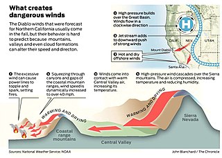
Diablo wind is a name that has been occasionally used for the hot, dry wind from the northeast that typically occurs in the San Francisco Bay Area of Northern California, during the spring and fall.

Mount Diablo is a mountain of the Diablo Range, in Contra Costa County of the eastern San Francisco Bay Area in Northern California. It is south of Clayton and northeast of Danville. It is an isolated upthrust peak of 3,849 feet, visible from most of the San Francisco Bay Area. Mount Diablo appears from many angles to be a double pyramid and has many subsidiary peaks. The largest and closest is North Peak, the other half of the double pyramid, which is nearly as high in elevation at 3,557 feet (1,084 m), and is about one mile northeast of the main summit.
Black Mountain may refer to:

Junipero Serra Peak is the highest mountain in the Santa Lucia range of central California with a height of 1,785 metres. It is also the highest peak in Monterey County, and is located within the boundaries of Los Padres National Forest. It is named after Saint Junípero Serra, the Spanish Franciscan priest who founded the California Missions in the 18th century. There is a fire lookout, with a tower and building, near the peak that was constructed around 1935. An unauthorized skiing operation on the summit was reported sometime before 1970. Good astronomical observing conditions were an early attraction to the peak. Astronomers scratched a trail to the summit in January 1880 to observe a total eclipse of the sun. Observations from the peak were also made on the transit of Venus in 1882.
Red Mountain may refer to:

Mount Hamilton is a mountain in the Diablo Range in Santa Clara County, California. The mountain's peak, at 4,265 feet (1,300 m), overlooks the heavily urbanized Santa Clara Valley and is the site of Lick Observatory, the world's first permanently occupied mountain-top observatory. The asteroid 452 Hamiltonia, discovered in 1899, is named after the mountain. Golden eagle nesting sites are found on the slopes of Mount Hamilton. On clear days, Mount Tamalpais, the Santa Cruz Mountains, Monterey Bay, the Monterey Peninsula, and even Yosemite National Park are visible from the summit of the mountain.
Devil's Backbone may refer to:

The Diablo Range is a mountain range in the California Coast Ranges subdivision of the Pacific Coast Ranges in northern California, United States. It stretches from the eastern San Francisco Bay area at its northern end to the Salinas Valley area at its southern end.
There are several places named Devil's Peak, Devils Peak or Devil Peak.
Devil's Canyon may refer to:

Devils Peak at 2,429 feet (740 m) is the tallest peak on the Channel Islands of California. It is located on Santa Cruz Island within Channel Islands National Park on land owned by The Nature Conservancy. Visiting the area requires a permit.

The Coast Ranges of California span 400 miles (644 km) from Del Norte or Humboldt County, California, south to Santa Barbara County. The other three coastal California mountain ranges are the Transverse Ranges, Peninsular Ranges and the Klamath Mountains.
The Gabilan Range or Gabilán Range are a mountain range in the inner California Coast Ranges System, located in Monterey County and San Benito County of central California. Pinnacles National Park is located in the southern section of the range.

Joseph D. Grant County Park is the largest county park in Santa Clara County, California. Also known as Grant Ranch Park, this site is situated in the Diablo Range foothills of the eastern Santa Clara Valley. The park is one of 28 owned by Santa Clara County and managed by the Santa Clara County Parks and Recreation Department.

Mount Stakes is a mountain in the Diablo Range in California. The peak is located on the Santa Clara–Stanislaus county line and is located less than 1 mile north of Henry W. Coe State Park. It rises to an elevation of 3,810 feet (1,161 m) and is the highest point in Stanislaus County. It is 22 miles (35 km) west of Newman and 32 miles (51 km) southeast of Livermore. Some snow falls on the peak during the winter.
Mount Boardman is located in the Diablo Range in California. The summit is near a point where Santa Clara, Alameda, Stanislaus, and San Joaquin counties meet. It was named for W. F. Boardman, the Alameda County surveyor between 1865 and 1869.
Pleasant Hill School may refer to:
Diablo Range is an unincorporated census county division (CCD) located in the Diablo Mountains Range, on the eastern side of Santa Clara County, California.
Devil's Pulpit may refer to:
Mustang Peak may refer to the following summits:
This page is based on this
Wikipedia article Text is available under the
CC BY-SA 4.0 license; additional terms may apply.
Images, videos and audio are available under their respective licenses.