
The Blue Mountains are a mountainous region and a mountain range located in New South Wales, Australia. The region is considered to be part of the western outskirts of the Greater Sydney area. The region borders on Sydney's main metropolitan area, its foothills starting about 50 kilometres (31 mi) west of centre of the state capital, close to Penrith. The public's understanding of the extent of the Blue Mountains is varied, as it forms only part of an extensive mountainous area associated with the Great Dividing Range. As defined in 1970, the Blue Mountains region is bounded by the Nepean and Hawkesbury rivers in the east, the Coxs River and Lake Burragorang to the west and south, and the Wolgan and Colo rivers to the north. Geologically, it is situated in the central parts of the Sydney Basin.

Yoho National Park is a national park of Canada. It is located within the Rocky Mountains along the western slope of the Continental Divide of the Americas in southeastern British Columbia, bordered by Kootenay National Park to the south and Banff National Park to the east in Alberta. The word Yoho is a Cree expression of amazement or awe, and it is an apt description for the park's spectacular landscape of massive ice fields and mountain peaks, which rank among the highest in the Canadian Rockies.
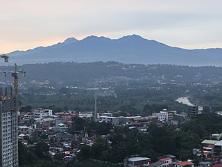
Mount Apo is the highest mountain peak in the Philippines, with an elevation of 2,954 meters (9,692 ft) above sea level. A large solfataric, dormant stratovolcano, it is part of the Apo-Talomo Mountain Range of Mindanao island. Apo is situated on the tripartite border of Davao City, Davao del Sur, and Cotabato; its peak is visible from Davao City 45 kilometers (28 mi) to the northeast, Digos 25 kilometers (16 mi) to the southeast, and Kidapawan 20 kilometers (12 mi) to the west. Apo is a protected area and is the centerpiece of Mount Apo Natural Park.

Mount Diablo is a mountain of the Diablo Range, in Contra Costa County of the eastern San Francisco Bay Area in Northern California. It is south of Clayton and northeast of Danville. It is an isolated upthrust peak of 3,849 feet, visible from most of the San Francisco Bay Area. Mount Diablo appears from many angles to be a double pyramid and has many subsidiary peaks. The largest and closest is North Peak, the other half of the double pyramid, which is nearly as high in elevation at 3,557 feet (1,084 m), and is about one mile northeast of the main summit.

Huangshan, literally meaning the Yellow Mountain(s), is a mountain range in southern Anhui province in eastern China. It was originally called "Yishan", and it was renamed because of a legend that Emperor Xuanyuan once made alchemy here. Vegetation on the range is thickest below 1,100 meters (3,600 ft), with trees growing up to the treeline at 1,800 meters (5,900 ft).

The Diablo Range is a mountain range in the California Coast Ranges subdivision of the Pacific Coast Ranges in northern California, United States. It stretches from the eastern San Francisco Bay Area at its northern end to the Salinas Valley area at its southern end.

Blue Mountain Peak is the highest mountain in Jamaica and one of the highest peaks in the Caribbean at 2,256 metres (7,402 ft), and the highest one outside of Hispaniola. It is the home of Blue Mountain coffee. It is located on the border of the Portland and Saint Thomas parishes of Jamaica.

Monte Titano is a mountain of the Apennines and the highest point in the country of San Marino. It stands 739 m (2,425 ft) above sea level Its peak is located within the municipal limits of the country's capital, San Marino, immediately east of the urbanized area.

Blue and John Crow Mountains National Park is a national park in Jamaica. The park covers 495.2 km2 and accounts for 4.5% of Jamaica's land surface. It gets its name from the Blue Mountains, the mountain range that runs through it, as well as a common bird found in the park, the "John crow" or turkey vulture. The park is globally known for its biodiversity. This park is the last of two known habitats of the giant swallowtail butterfly, the largest butterfly in the Western Hemisphere and also the habitat for the endangered Jamaican blackbird, a refuge for the Jamaican boa and the Jamaican hutia.

The Albion Mountains are a mountain range in the U.S. states of Idaho (~99%) and Utah (~1%), spanning Cassia County, Idaho and barely reaching into Box Elder County, Utah. The highest point in the range is Cache Peak at 10,339 feet (3,151 m), and the range is a part of the Basin and Range Province. Most of the mountains are part of the Albion Division of the Minidoka Ranger District of Sawtooth National Forest.
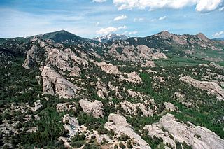
Cache Peak, at 10,339 feet (3,151 m) above sea level, is the highest peak in the Albion Mountains of Cassia County in Southern Idaho. Cache Peak is located in the central part of the range southeast of Oakley and north of Almo in the Albion Division of the Minidoka Ranger District of Sawtooth National Forest.

The Sierra Madre is the longest mountain range in the Philippines. Spanning over 540 kilometers (340 mi), it runs from the province of Cagayan down to the province of Quezon, forming a north–south direction on the eastern portion of Luzon, the largest island of the archipelago. It is bordered by the Pacific Ocean to the east, Cagayan Valley to the northwest, Central Luzon to the midwest, and Calabarzon to the southwest. Some communities east of the mountain range, along the coast, are less developed and so remote that they could only be accessed by taking a plane or a boat.
La Vereda del Monte was a backcountry route through remote regions of the Diablo Range, one of the California Coast Ranges. La Vereda del Monte was the upper part of La Vereda Caballo,, used by mesteñeros from the early 1840s to drive Alta California horses to Sonora for sale.
Juan de Serras was one of the first Jamaican Maroon chiefs in the seventeenth century. His community was based primarily around Los Vermajales, and as a result the English called his group of Maroons the Karmahaly Maroons. It is likely that his Maroons are descended from escaped slaves Taino men and women.