
The Caribbean Island of Jamaica was initially inhabited in approximately 600 AD or 650 AD by the Redware people, often associated with redware pottery. By roughly 800 AD, a second wave of inhabitance occurred by the Arawak tribes, including the Tainos, prior to the arrival of Columbus in 1494. Early inhabitants of Jamaica named the land "Xaymaca", meaning "land of wood and water". The Spanish enslaved the Arawak, who were ravaged further by diseases that the Spanish brought with them. Early historians believe that by 1602, the Arawak-speaking Taino tribes were extinct. However, some of the Taino escaped into the forested mountains of the interior, where they mixed with runaway African slaves, and survived free from first Spanish, and then English, rule.
Maroons are descendants of Africans in the Americas and Islands of the Indian Ocean who escaped from slavery and formed their own settlements. They often mixed with indigenous peoples, eventually evolving into separate creole cultures such as the Garifuna and the Mascogos.
Old Nanny Town was a village in the Blue Mountains of Portland Parish, north-eastern Jamaica, used as a stronghold of Jamaican Maroons. They were led in the early 18th century by an Ashanti escaped slave known as Granny Nanny, or Queen Nanny. The town held out against repeated attacks from the colonial militia before being abandoned in 1734.

Queen Nanny, Granny Nanny, or Nanny of the Maroons ONH, was an 18th-century leader of the Jamaican Maroons. She led a community of formerly enslaved Africans called the Windward Maroons. In the early 18th century, under the leadership of Nanny, the Windward Maroons fought a guerrilla war over many years against British authorities in the Colony of Jamaica in what became known as the First Maroon War.
The First Maroon War was a conflict between the Jamaican Maroons and the colonial British authorities that started around 1728 and continued until the peace treaties of 1739 and 1740. It was led by self-liberated Africans who set up communities in the mountains. The name "Maroon" was given to these Africans, and for many years they fought the British colonial Government of Jamaica for their freedom. The maroons were very skilled, particularly in guerrilla warfare. It was followed about half a century later by the Second Maroon War.
Tacky's War, Tacky's Revolt, or Tacky's Rebellion was a widespread fight for their freedom by enslaved people in the British Colony of Jamaica in the 1760s. Led by Akan people —tribes including Ashanti, Fanti, Nzema and Akyem—it was loosely led by a Fanti royal and warlord called Tacky (TwiTakyi) in eastern Jamaica, and Dahomean war chief or coastal headman Apongo in the western end of the island.
Jamaican Maroons descend from Africans who freed themselves from slavery on the Colony of Jamaica and established communities of free black people in the island's mountainous interior, primarily in the eastern parishes. Africans who were enslaved during Spanish rule over Jamaica (1493–1655) may have been the first to develop such refugee communities.
Colonel Sir Thomas Modyford, 1st Baronet was a planter of Barbados and Governor of Jamaica from 1664 to 1671.
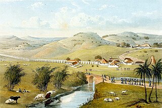
Moore Town is a Maroon settlement located in the Blue Mountains and John Crow Mountains of Portland, Jamaica, accessible by road from Port Antonio. The easternmost Maroon town, Moore Town is located in the eastern end of the parish. Formerly known as New Nanny Town, Moore Town was founded in 1740 when the Peace Treaty was signed between the British colonial authorities and the Windward Maroons. This treaty allotted the Moore Town Maroons 1000 acres, but Moore Town only received 500. In 1781 the initial 500 acres was augmented with another 500 acres, taking their communal land up to 1,000 acres.

The Invasion of Jamaica took place in May 1655, during the 1654 to 1660 Anglo-Spanish War, when an English expeditionary force captured Spanish Jamaica. It was part of an ambitious plan by Oliver Cromwell to acquire new colonies in the Americas, known as the Western Design.
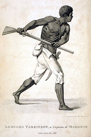
Cudjoe, Codjoe or Captain Cudjoe, sometimes spelled Cudjo – corresponding to the Akan day name Kojo, Codjoe or Kwadwo – was a Maroon leader in Jamaica during the time of Nanny of the Maroons. In Twi, Cudjoe or Kojo is the name given to a boy born on a Monday. He has been described as "the greatest of the Maroon leaders."

Santiago was a Spanish territory of the Spanish West Indies and within the Viceroyalty of New Spain, in the Caribbean region. Its location is the present-day island and nation of Jamaica.

The Crown Colony of Jamaica and Dependencies was a British colony from 1655, when it was captured by the English Protectorate from the Spanish Empire. Jamaica became a British colony from 1707 and a Crown colony in 1866. The Colony was primarily used for sugarcane production, and experienced many slave rebellions over the course of British rule. Jamaica was granted independence in 1962.
The Colony of Jamaica gained independence from the United Kingdom on 6 August 1962. In Jamaica, this date is celebrated as Independence Day, a national holiday.
Juan de Bolas originally Juan Lubolo (1604?-1664) was one of the first chiefs of the Jamaican Maroons.
The Juan de Bolas River rises in Saint Catherine, Jamaica, and flows through Saint Catherine and Clarendon. It is one of two rivers in Jamaica named after Juan de Bolas, the first Chief of the Jamaican Maroons.
Juan de Serras was one of the first Jamaican Maroon chiefs in the seventeenth century. His community was based primarily around Los Vermajales, and as a result the English called his group of Maroons the Karmahaly Maroons. It is likely that his Maroons are descended from escaped African slaves and Taino men and women.
Edward D'Oyley was an English soldier who served as Governor of Jamaica on two occasions.
Free black people in Jamaica fell into two categories. Some secured their freedom officially, and lived within the slave communities of the Colony of Jamaica. Others ran away from slavery, and formed independent communities in the forested mountains of the interior. This latter group included the Jamaican Maroons, and subsequent fugitives from the sugar and coffee plantations of coastal Jamaica.
