Related Research Articles

St. Albans is a residential neighborhood in the southeastern portion of the New York City borough of Queens. It is bordered by Jamaica to the northwest, Hollis to the north, Queens Village to the northeast, Cambria Heights to the east, Laurelton to the southeast, Springfield Gardens to the south, and South Jamaica to the southwest. St. Albans is centered on the intersection of Linden Boulevard and Farmers Boulevard, about two miles north of John F. Kennedy International Airport.
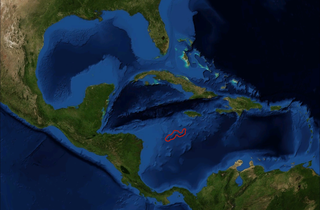
Serranilla Bank is a partially submerged reef, with small uninhabited islets, in the western Caribbean Sea. It is situated about 350 kilometres (220 mi) northeast of Punta Gorda, Nicaragua, and roughly 280 kilometres (170 mi) southwest of Jamaica. The closest neighbouring land feature is Bajo Nuevo Bank, located 110 kilometres (68 mi) to the east.

Westmoreland is the westernmost parish in Jamaica, located on the south side of the island. It is situated south of Hanover, southwest of Saint James, and northwest of Saint Elizabeth, in the county of Cornwall. The chief town and capital is Savanna-la-Mar. Negril, a famous tourist destination, is also situated in the parish.
Wikimapia is an internet company that provides an open-content collaborative mapping project. The project implements an interactive "clickable" web map that utilizes google maps with a geographically-referenced wiki system, with the aim to mark and describe all geographical objects in the world.

South Negril Point is the westernmost point of mainland Jamaica. It is located a little south of the resort town of Negril and a little north of Negril Lighthouse.
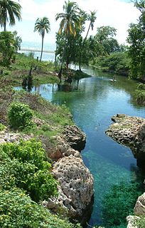
Gut River is a river, beach and small hamlet on an isolated stretch of south facing coastline in Manchester, Jamaica. The name is said by the locals to derive from the German word for good.

Treasure Beach is the name given to a stretch of four Jamaican coves and their associated settlements: Billy's Bay, Frenchman's Bay, Calabash Bay and Great Pedro Bay.
The Bog Walk to Port Antonio railway was a railway in Jamaica built to serve the banana, cacao, citrus and coconut districts of St Catherine, St Mary and Portland.
The Embassy of Senegal in Washington, D.C. is the diplomatic mission of the Republic of Senegal to the United States. The building is located at 2215 M Street Northwest in the Kalorama neighborhood of Washington, D.C.

Kyaukme is a town in northern Shan State of Burma. It is situated on the Mandalay - Lashio road, after Pyin Oo Lwin and Nawnghkio, and before Hsipaw, on what is now the Mandalay - Muse road, part of the Asian Highway route 14 (AH14). It is also connected to Momeik (Mongmit) in the Shweli River valley and Mogok with its ruby mines. Kyaukme can be reached by train on the Mandalay-Lashio railway line.
Curries Woods is a neighborhood in the southern part of Greenville in Jersey City, New Jersey bordering Bayonne. It was named after James Curie, who was on the town Committee for Greenville when it was its own Township in the 19th century. The area remained rural until the later part of the century when the Central Railroad of New Jersey built a line connecting ferries to Elizabeth, New Jersey and New York City. Currie's Woods still remained untouched through the late part of the century and it was valued for its woods, rocky shore and dunes on Newark Bay. A lot of the land was eventually lost, but a tract was set aside in the early part of the 20th century. A small cemetery, the Old Greenville Cemetery, was nearby. This park lost much of its land to the city's largest Housing Authority project in 1959, except a small tract in Bayonne, Mercer Park.

Portland Cottage light structure formerly Portland Lighthouse sometimes Portland Point Lighthouse is situated on the summit of Portland Ridge, Clarendon, near the southernmost part of Jamaica.
Long Bay Beach is an almost deserted 10 miles (16 km) crescent of black sand on the central south coast of Jamaica in Manchester Parish.
Half Moon Point is the northernmost point of mainland Jamaica. It is named for the resort on whose property it sits. Immediately to its west is Half Moon Bay, and a little to its east is Rose Hall.
Southfield is a farming town on the southern ridge of the Santa Cruz Mountains in St Elizabeth, Jamaica.
The Rotten Gut River is a short river in the parish of Manchester, Jamaica and a tributary of the One Eye River.

James Bond Beach—also known as Laughing Waters Beach and Roaring River Beach—is a beach that sits on a small peninsula at Oracabessa Bay, about 10 miles (16 km) from Ocho Rios on Jamaica's north coast. The beach has brightly painted changing rooms, a water sports centre, a bar, and a restaurant. It is surrounded by crystal clear water on three sides, and the mountains of St Mary reach straight down to the sea, a sight which serves as the beach's backdrop. Its expansive lawns are a regular venue for concerts by international artists such as Rihanna, Ziggy Marley, and Lauryn Hill.
Miss Earth Jamaica is an annual national beauty pageant to select a delegate to represent Jamaica at the international Miss Earth pageant.The current Miss Earth Jamaica is Catherine Harris who was crowned on September 23, 2020.
Cross Roads is a primarily commercial neighbourhood of Kingston, Jamaica. It is centered on the intersection of five major roads: Slipe Road, Half Way Tree Road, Old Hope Road, Caledonia Avenue and Marescaux Road.
References
- General
- GEOnet Names Server
- OMC Map
- CIA Map
- Ford, Jos C. and Finlay, A.A.C. (1908).The Handbook of Jamaica. Jamaica Government Printing Office
- Inline
- ↑ "Wikimapia 1". Archived from the original on 27 September 2009. Retrieved 2009-09-10.
- ↑ "Wikimapia 2". Archived from the original on 27 September 2009. Retrieved 2009-09-10.
| This article related to a river in Jamaica is a stub. You can help Wikipedia by expanding it. |